And I slept through both storms that hit here apparently a few hours ago. I do recall some thunder rumbling around but only just woke up now. Airport AWS recorded 15.6mm. Not bad.
Grovedale (microburst/tornado?) and Kilmore (hail), seem to have copped it pretty hard.

Welcome New Members! We want to hear from you. Register, stop lurking and start posting!
Strong front and cutoff low: May 20-25
- StratoBendigo
- Supercell
- Reactions:
- Posts: 2809
- Joined: Fri Jan 02, 2015 2:18 pm
- Location: Kangaroo Flat
- Tassiedave
- Supercell
- Reactions:
- Posts: 1098
- Joined: Thu Nov 11, 2010 11:09 am
- Location: Grindelwald Tasmania
Re: Strong front and cutoff low: May 20-25
Rain as of 630am: Pine Tree Rivulet 41mm, Liawenee 23mm, Meander 16mm, Sheffield 13mm, Deloraine 13mm, Launceston 9.0mm
-
Onetahuti

- Supercell
- Reactions:
- Posts: 2790
- Joined: Thu Mar 25, 2010 9:37 pm
- Location: Dandenong Nth.
Re: Strong front and cutoff low: May 20-25
Think I stirred enough to hear distant thunder which it could have been, 18mm in the Nylex.
- snowfall
- Supercell
- Reactions:
- Posts: 1283
- Joined: Mon Mar 20, 2017 7:39 pm
- Location: Gisborne South (349m asl)
Re: Strong front and cutoff low: May 20-25
That was quite a storm overnight - woke up to heavy rain, ferocious wind, and some big booms of thunder. 16.8mm.
- Wilko
- Supercell
- Reactions:
- Posts: 1492
- Joined: Wed Aug 11, 2010 12:08 pm
- Location: Moorabbin & Highett, Vic
Re: Strong front and cutoff low: May 20-25
14mm this side of the black stump 
-
hillybilly

- Site Admin/Moderator
- Reactions:
- Posts: 4979
- Joined: Thu Nov 26, 2009 7:26 am
- Location: Howden Tasmania, 25m above sea level
- Contact:
Re: Strong front and cutoff low: May 20-25
Crikey that was a wild night. Felt like the opening scene of War of the Worlds. Strobe lightning, small hail and 21.2mm in the gauge. Looks like the Melbourne Water station network was taken out in northeast burbs with lots of stations reading low 
Not a too bad day today, but strong front approaches overnight with a solid wintery burst. Still need around 50mm here to get to our monthly average so need it to keep ticking over.
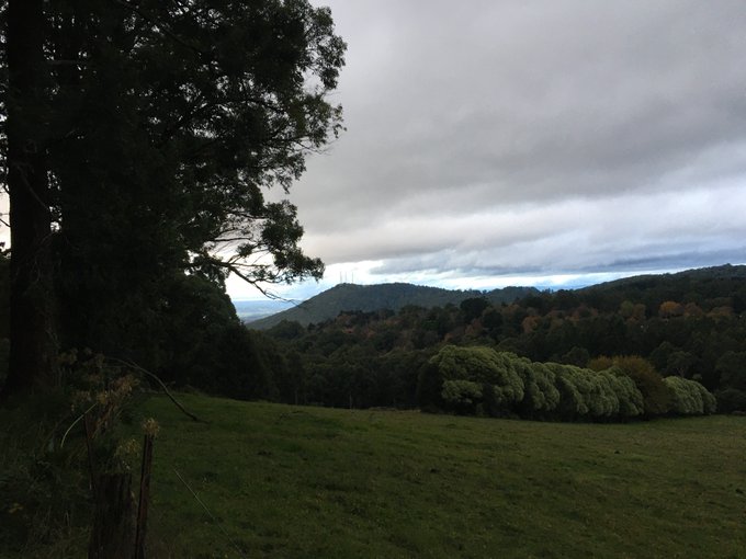
A photo from this morning showing moody skies over Mt Dandenong.
Not a too bad day today, but strong front approaches overnight with a solid wintery burst. Still need around 50mm here to get to our monthly average so need it to keep ticking over.
A photo from this morning showing moody skies over Mt Dandenong.
- flyfisher
- Cumulonimbus
- Reactions:
- Posts: 250
- Joined: Wed Jul 18, 2012 1:39 pm
- Location: Belgrave
- Contact:
Re: Strong front and cutoff low: May 20-25
Great storm last night - woke up the kids, the cats were howling as they hate heavy rain. Lots of hail too.
Pity that huge NW cloud band is not going to link up with the the front - it would be a great inland dumper if it did.
Pity that huge NW cloud band is not going to link up with the the front - it would be a great inland dumper if it did.
- StratoBendigo
- Supercell
- Reactions:
- Posts: 2809
- Joined: Fri Jan 02, 2015 2:18 pm
- Location: Kangaroo Flat
Re: Strong front and cutoff low: May 20-25
17mm here. Perhaps another 10mm tonight and tomorrow which will be great.
I'm watching the out-of-season rains up North with interest. Tennant Creek and Mt Isa are a good shot at recording record low Max temps for May. And the Pilbara and Gasgoyne could really get a big soaking.
I'm watching the out-of-season rains up North with interest. Tennant Creek and Mt Isa are a good shot at recording record low Max temps for May. And the Pilbara and Gasgoyne could really get a big soaking.
- StratoBendigo
- Supercell
- Reactions:
- Posts: 2809
- Joined: Fri Jan 02, 2015 2:18 pm
- Location: Kangaroo Flat
Re: Strong front and cutoff low: May 20-25
Already officially our wettest Autumn since 2010. Although unofficially the wettest where I live since Autumn 1974. Just 35 mm this month so far though.
Years with more than 200 mm in Autumn in Bendigo include 2020, 2010, 1989, 1983, 1974, 1970, 1968, 1960, 1950, 1939, 1931, 1918, 1900, 1893, 1880, 1878, 1877.
Years with more than 200 mm in Autumn in Bendigo include 2020, 2010, 1989, 1983, 1974, 1970, 1968, 1960, 1950, 1939, 1931, 1918, 1900, 1893, 1880, 1878, 1877.
- Dane
- Supercell
- Reactions:
- Posts: 1661
- Joined: Thu Nov 26, 2009 9:51 am
- Location: Sebastopol 420m ASL
- Contact:
Re: Strong front and cutoff low: May 20-25
15mm's overnight with that storm My MTD now 60.2mm's.
Airport had 13.4mm's - MTD 54.4mm's. Wind gusted to 98kmh - 53 knots in that storm.
Next front just moving into the far SW of the state now.
Airport had 13.4mm's - MTD 54.4mm's. Wind gusted to 98kmh - 53 knots in that storm.
Next front just moving into the far SW of the state now.
-
hillybilly
- Site Admin/Moderator
- Reactions:
- Posts: 4979
- Joined: Thu Nov 26, 2009 7:26 am
- Location: Howden Tasmania, 25m above sea level
- Contact:
Re: Strong front and cutoff low: May 20-25
Chilly max of 9.4C here today. Quite cold in the wind with stratus racing overhead.
Main front inbound. Looks like a rainy night ahead. Not expecting rumbles, but might be a chance. Cold air then shoots into the Tasman with a deep low to develop near Sydney.
Btw check out EC for next week in WA. TC or TD capture by a front. Low could be a record breaker. Looks very nasty if it verifies with a big surge, gales, rain and fire weather.
- Macedonian
- Supercell
- Reactions:
- Posts: 2330
- Joined: Mon Dec 21, 2009 10:44 pm
- Location: Mount Macedon Vic at 870m above sea level
Re: Strong front and cutoff low: May 20-25
We had just over 24mm last night. Very stormy and a cold day. Only 3C now.
Home- "Shepherd's Bush" at Mt Macedon. 870m
Work- "Bolobek" at Macedon. 430m
Work- "Bolobek" at Macedon. 430m
- QldTwister
- Cumulonimbus
- Reactions:
- Posts: 432
- Joined: Tue May 22, 2012 7:56 pm
- Location: Ashwood Vic
Re: Strong front and cutoff low: May 20-25
Yeah some major damage to some of the houses their from some destructive winds very localised.
Radar dont look very tornado like intresting picture maybe looking along some type of gust front, dam tree in way
Team went down today to acess it, sadly I couldnt get down there today.
21mm here overnight with a nice hour or so of lightning and thunder was very nice felt spring summer like many more of these please.
Another front tonight will stand up tilt cut off and weaken bout another 10-20mm in the Sw and NE 5-15mm else were less in the NW
Then cold and Slys for days and days between high in bight and low in the Tasmen
EPIC EPIC system progged for WA next week WOW
Impressive rainband across the tropical north too it all happening
Bring on the heat and stroms
- dazrain
- Cumulonimbus
- Reactions:
- Posts: 111
- Joined: Thu Feb 03, 2011 7:39 pm
- Location: Brighton East, Victoria
Re: Strong front and cutoff low: May 20-25
Check out Saturday’s forecast for Cairns.
I’ve never seen a minimum and maximum equal to each other!
Min 20 Max 20. Rain.
I’ve never seen a minimum and maximum equal to each other!
Min 20 Max 20. Rain.
- Tassiedave
- Supercell
- Reactions:
- Posts: 1098
- Joined: Thu Nov 11, 2010 11:09 am
- Location: Grindelwald Tasmania
Re: Strong front and cutoff low: May 20-25
Tas Rain last 24 hrs: Mt Barrow 40mm, Lake Margaret 28mm, Mt Victoria 21mm, Launceston 19mm, Wynyard 15mm, Hobart 0.4mm
-
hillybilly
- Site Admin/Moderator
- Reactions:
- Posts: 4979
- Joined: Thu Nov 26, 2009 7:26 am
- Location: Howden Tasmania, 25m above sea level
- Contact:
Re: Strong front and cutoff low: May 20-25
Rainy night up here with about 16mm in the gauge. Heavier falls just to my near north where a patch of heavy rain stalled for an hour or so with 20-30mm around areas on the western face of the Nongs. Gonna be slow to clear, but once it does then fine or mostly fine for a longish stretch for most. Showers will be more persistent around the Otways, west coast and Gippsland.
Low now starts to spin up on the east coast off Sydney.
Low now starts to spin up on the east coast off Sydney.
- snowfall
- Supercell
- Reactions:
- Posts: 1283
- Joined: Mon Mar 20, 2017 7:39 pm
- Location: Gisborne South (349m asl)
Re: Strong front and cutoff low: May 20-25
Mix of showers and drizzle here this morning. 13.6mm since midnight. MTD now 52mm and YTD 519mm.
- Tassiedave
- Supercell
- Reactions:
- Posts: 1098
- Joined: Thu Nov 11, 2010 11:09 am
- Location: Grindelwald Tasmania
Re: Strong front and cutoff low: May 20-25
Wow that's a massive LOW off Western Australia on Sunday!
-
hillybilly
- Site Admin/Moderator
- Reactions:
- Posts: 4979
- Joined: Thu Nov 26, 2009 7:26 am
- Location: Howden Tasmania, 25m above sea level
- Contact:
Re: Strong front and cutoff low: May 20-25
Finished on 21mm to 9am and 21mm the day before. Decent top-up for May. Top falls locally are on the front face of the Nongs with falls between 20 and 25mm.
Looks to be starting to clear here now.
Looks to be starting to clear here now.