Welcome New Members! We want to hear from you. Register, stop lurking and start posting!
La Nina - El Nino - IOD
- JasmineStorm
- Supercell
- Reactions:
- Posts: 1870
- Joined: Thu Sep 22, 2016 9:40 pm
- Location: Kyneton 527 ASL
Re: La Nina - El Nino - IOD
Indian Ocean has warmed of NW Australia and cooled off East Africa in the last 7 days. Interesting change and one to watch in the next 2 weeks relating to the IOD.
- Attachments
-
- SST change Indian Ocean last 7 days.jpg (108.94 KiB) Viewed 17855 times
- Geoff
- Supercell
- Reactions:
- Posts: 2538
- Joined: Tue Jul 05, 2011 9:46 pm
- Location: Olinda VIC (470m ASL)
Re: La Nina - El Nino - IOD
Encouraging signs taking place in the Indian Ocean now, with warming to our N/W and cooling over towards Africa. Rainfall prospects should continue to improve if this development continues.


AWF Rainfall Details - Monthly rainfall stats. Please post your totals here at the end of each month, thank you –
http://www.theaustralianweatherforum.co ... &start=180
http://www.theaustralianweatherforum.co ... &start=180
- JasmineStorm
- Supercell
- Reactions:
- Posts: 1870
- Joined: Thu Sep 22, 2016 9:40 pm
- Location: Kyneton 527 ASL
Re: La Nina - El Nino - IOD
Good pick up Geoff. Interesting signs also on the eastern side of the Pacific.... looks a little La Nina-ish
- Gordon
- Supercell
- Reactions:
- Posts: 2950
- Joined: Thu Jun 17, 2010 10:01 am
- Location: Near Gordon, Vic. 620 m asl
Re: La Nina - El Nino - IOD
Sneaky little 'mid-term' revision from BOM here: http://www.bom.gov.au/climate/outlooks/ ... ew/summary
Looks like the apocalyptically dry spring forecast (http://www.bom.gov.au/climate/ahead/arc ... look.shtml) needed urgent attention!
I wonder what period the 31 August outlook will apply to given the 17 August forecast is for Sept-Nov?
Looks like the apocalyptically dry spring forecast (http://www.bom.gov.au/climate/ahead/arc ... look.shtml) needed urgent attention!
I wonder what period the 31 August outlook will apply to given the 17 August forecast is for Sept-Nov?
- JasmineStorm
- Supercell
- Reactions:
- Posts: 1870
- Joined: Thu Sep 22, 2016 9:40 pm
- Location: Kyneton 527 ASL
Re: La Nina - El Nino - IOD
Yes, Gordon. Well spotted. They have got August wrong now 2 years in a row. Last year they said the IOD was weakening and then KABOOM within 2 weeks. This year they underestimated the westerly conveyor belt. They should stick to 14 days forecasts until climate modelling becomes more accurate IMO.Gordon wrote: ↑Sun Aug 20, 2017 11:54 am Sneaky little 'mid-term' revision from BOM here: http://www.bom.gov.au/climate/outlooks/ ... ew/summary
Looks like the apocalyptically dry spring forecast (http://www.bom.gov.au/climate/ahead/arc ... look.shtml) needed urgent attention!
I wonder what period the 31 August outlook will apply to given the 17 August forecast is for Sept-Nov?
- JasmineStorm
- Supercell
- Reactions:
- Posts: 1870
- Joined: Thu Sep 22, 2016 9:40 pm
- Location: Kyneton 527 ASL
Re: La Nina - El Nino - IOD
I've been watching the Pacific over the last 2 weeks and it has held steady on a La Nina set up. It's becoming interesting now IMO 
- Attachments
-
- Aug 27 pacific.jpg (366.23 KiB) Viewed 17618 times
- Didjman
- Supercell
- Reactions:
- Posts: 2104
- Joined: Fri Sep 03, 2010 2:52 pm
- Location: Wallan, Vic 328m ASL
- Contact:
Re: La Nina - El Nino - IOD
So JS, could that translate into a good storm season here?
Peter
Peter
- JasmineStorm
- Supercell
- Reactions:
- Posts: 1870
- Joined: Thu Sep 22, 2016 9:40 pm
- Location: Kyneton 527 ASL
Re: La Nina - El Nino - IOD
Yes Peter, If the atmosphere aligns with the ocean temps in the next month, I think it will be double the storms of the last couple of years for eastern and south east Australia. NSW and QLD especially but Victoria definitely increased. The coral sea is unusually warm, so an early start to cyclone season has potential as well.
- JasmineStorm
- Supercell
- Reactions:
- Posts: 1870
- Joined: Thu Sep 22, 2016 9:40 pm
- Location: Kyneton 527 ASL
- Gordon
- Supercell
- Reactions:
- Posts: 2950
- Joined: Thu Jun 17, 2010 10:01 am
- Location: Near Gordon, Vic. 620 m asl
Re: La Nina - El Nino - IOD
Great pick JS and Peter; and JS - welcome back  ! (We miss you!)
- JasmineStorm
- Supercell
- Reactions:
- Posts: 1870
- Joined: Thu Sep 22, 2016 9:40 pm
- Location: Kyneton 527 ASL
- StratoBendigo
- Supercell
- Reactions:
- Posts: 2924
- Joined: Fri Jan 02, 2015 2:18 pm
- Location: Kangaroo Flat
Re: La Nina - El Nino - IOD
It took a while to get going here, but late-Nov has delivered.
- JasmineStorm
- Supercell
- Reactions:
- Posts: 1870
- Joined: Thu Sep 22, 2016 9:40 pm
- Location: Kyneton 527 ASL
Re: La Nina - El Nino - IOD
Going to be an interesting Summer 
- Attachments
-
- EC Nov 29.jpg (240.94 KiB) Viewed 17124 times
- Gordon
- Supercell
- Reactions:
- Posts: 2950
- Joined: Thu Jun 17, 2010 10:01 am
- Location: Near Gordon, Vic. 620 m asl
Re: La Nina - El Nino - IOD
One for Jasmine, hillybilly or any other experts that care to venture an opinion please?
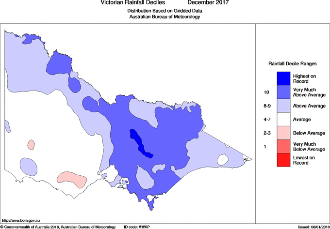
During late spring/and through summer in La Nina years, there is an almost unbelievably sharp rainfall 'line' that forms between just west of Port Phillip, angling up roughly through Bendigo and on up into the northern Mallee. West of this line, there is little rain or thunderstorm activity; east of it and the heavens open! In this setup (and about half a dozen times this summer) I often watch castellus or young cumulus clouds form up overhead, but only produce rain once they've travelled across the line.
The December 2017 rainfall map shows this rather neatly:

Any thoughts on what causes this divide? Is it something to do with the topography of the ocean wedge between Cape Otway and Wilson's Prom? Or are other factors at play?
During late spring/and through summer in La Nina years, there is an almost unbelievably sharp rainfall 'line' that forms between just west of Port Phillip, angling up roughly through Bendigo and on up into the northern Mallee. West of this line, there is little rain or thunderstorm activity; east of it and the heavens open! In this setup (and about half a dozen times this summer) I often watch castellus or young cumulus clouds form up overhead, but only produce rain once they've travelled across the line.
The December 2017 rainfall map shows this rather neatly:

Any thoughts on what causes this divide? Is it something to do with the topography of the ocean wedge between Cape Otway and Wilson's Prom? Or are other factors at play?
- JasmineStorm
- Supercell
- Reactions:
- Posts: 1870
- Joined: Thu Sep 22, 2016 9:40 pm
- Location: Kyneton 527 ASL
Re: La Nina - El Nino - IOD
Interesting question Gordon... I'm not sure I have an exact answer but the placement of the high pressure ridge's during this La Nina may have something to do with it. It's been quite a north easterly flow and no real big easterly dip so far. I think, that once the coral sea starts seeing tropical depressions from the monsoon trough, troughs will move west with an associated inland low / easterly dip. Here is the position of the 2011 trough that dropped around 260mm around here in early January when the monsoon trough pushed down. time will tellGordon wrote: ↑Tue Jan 09, 2018 2:42 pm One for Jasmine, hillybilly or any other experts that care to venture an opinion please?
During late spring/and through summer in La Nina years, there is an almost unbelievably sharp rainfall 'line' that forms between just west of Port Phillip, angling up roughly through Bendigo and on up into the northern Mallee. West of this line, there is little rain or thunderstorm activity; east of it and the heavens open! In this setup (and about half a dozen times this summer) I often watch castellus or young cumulus clouds form up overhead, but only produce rain once they've travelled across the line.
The December 2017 rainfall map shows this rather neatly:
Any thoughts on what causes this divide? Is it something to do with the topography of the ocean wedge between Cape Otway and Wilson's Prom? Or are other factors at play?
- Attachments
-
- Jan 2011.jpg (167.63 KiB) Viewed 16786 times
- Gordon
- Supercell
- Reactions:
- Posts: 2950
- Joined: Thu Jun 17, 2010 10:01 am
- Location: Near Gordon, Vic. 620 m asl
Re: La Nina - El Nino - IOD
Thanks for your response JS. It would be nice if those troughs moved a bit west - after a green December we are really drying off now.
- JasmineStorm
- Supercell
- Reactions:
- Posts: 1870
- Joined: Thu Sep 22, 2016 9:40 pm
- Location: Kyneton 527 ASL
Re: La Nina - El Nino - IOD
This is going to go big, once the monsoon trough arrives in February off the east coast. These Sea surface temps are starting to look nuclear for a synoptic scale attack. 26c tropical cyclone SST line has dropped south off the Northern NSW coast.
- Attachments
-
- SST Jan 17th 2018.jpg (336.36 KiB) Viewed 16572 times
- Wilko
- Supercell
- Reactions:
- Posts: 1514
- Joined: Wed Aug 11, 2010 12:08 pm
- Location: Moorabbin & Highett, Vic
Re: La Nina - El Nino - IOD
That is an insane sea surface temp
1 or 2 degrees makes a huge difference and these temps are a recipe for something very big
1 or 2 degrees makes a huge difference and these temps are a recipe for something very big
- JasmineStorm
- Supercell
- Reactions:
- Posts: 1870
- Joined: Thu Sep 22, 2016 9:40 pm
- Location: Kyneton 527 ASL
Re: La Nina - El Nino - IOD
Interesting updated outlook from the agencies for a potential negative IOD in winter. Also noticed a SST shift in the Indian ocean in recent times.
- Attachments
-
- IOD outlook June 2018.jpg (168.3 KiB) Viewed 15948 times
- Gordon
- Supercell
- Reactions:
- Posts: 2950
- Joined: Thu Jun 17, 2010 10:01 am
- Location: Near Gordon, Vic. 620 m asl
Re: La Nina - El Nino - IOD
Thanks JS. No guarantees, but at least the trend is towards a negative IOD rather than the dreaded positive IOD.
The one reliable rain forecaster of any use to us here (far west central VIc) is a negative IOD - without fail it brings us average to above average winter/spring rain. (Unlike useless (for us) La Nina!)
The one reliable rain forecaster of any use to us here (far west central VIc) is a negative IOD - without fail it brings us average to above average winter/spring rain. (Unlike useless (for us) La Nina!)