Welcome New Members! We want to hear from you. Register, stop lurking and start posting!

Victoria: Major upper and surface lows - 12–16 Dec 2018

Archived Weather Events since 2009.
If you have any valuable content to add to any locked thread, please PM board moderator.
Locked
j
jimmyay
Cumulonimbus
Reactions:
Posts: 163
Joined: Thu Dec 13, 2012 2:33 pm
Location: Port Melbourne

Re: Major upper and surface lows 12–16 Dec

Post by jimmyay »

Woken by an incredible thunder crack at about 330 am on Brighton. Not sure how localissed it was, city recorded around 2mm at that time but this morning apparent that our area had had a huge soak overnight having missed the earlier evening storm.

Baysides had about 7 inches of rain over the past 6 weeks - more than the previous 6 months ! 😂
S
Skywalker
Supercell
Reactions:
Posts: 1872
Joined: Sun Nov 29, 2009 10:03 am
Location: Burnside Heights/Cowes (Home) & Sunshine West (Work)

Re: Major upper and surface lows 12–16 Dec

Post by Skywalker »

Good morning all. :D

Look like things are off to an early start down there.
Very humid here in Sydney. Have no doubt it will go off here later, possibly impacting my flight yet again.
Caroline Springs, Melbourne's meteorological boredom zone.
J
James
Supercell
Reactions:
Posts: 1059
Joined: Wed Nov 25, 2009 6:10 pm
Location: Boronia

Re: Major upper and surface lows 12–16 Dec

Post by James »

Not sure if there was any thunder here at 3am, i did not wake up - nor did the dog, so it must have missed us here?

Dissapointing to see again the lightning skirting to the north - this system has certainly been lightning active for the western and north central.

Wonder what will happen today, so far it hasnt gone to plan as what the forecasters said (sunny morning and clear for melb), so i think its just going to do its own thing!
w
weathergasm
Cumulonimbus
Reactions:
Posts: 244
Joined: Sun Feb 14, 2010 9:32 pm
Location: Box Hill

Re: Major upper and surface lows 12–16 Dec

Post by weathergasm »

Here in Camberwell it has that warm, muggy, still feeling I like when hoping for a storm. I'm pretty optimistic for this afternoon and evening, because this airmass has to be changed somehow!
s
stevco123
Supercell
Reactions:
Posts: 2936
Joined: Sat Aug 07, 2010 7:42 pm
Location: Cranbourne 78m asl

Re: Major upper and surface lows 12–16 Dec

Post by stevco123 »

All starting to develop to the north east of Melbourne now. You can JUST see it on the 128km radar. Trajectory still appears to miss the south east suburbs thanks to the high ranges to our north east.

Let's see how we go. Still no confidence
https://www.weatherlink.com/bulletin/53 ... 76dd68e8bc: for current weather updated every 2 minutes
A
Adam38
Cumulonimbus
Reactions:
Posts: 486
Joined: Tue Jul 31, 2018 1:57 pm
Location: Bacchus Marsh

Re: Major upper and surface lows 12–16 Dec

Post by Adam38 »

I don’t know if it’s just me but the sky has a dusty reddy brown look to it here, maybe the low has sucked in some dust from NSW?
T
Tassiedave
Supercell
Reactions:
Posts: 1098
Joined: Thu Nov 11, 2010 11:09 am
Location: Grindelwald Tasmania

Re: Major upper and surface lows 12–16 Dec

Post by Tassiedave »

Things ramping up in North East Tassie. Conveyor Belt of moisture streaming into the northern half of the state. Gray is up to 27 mm since 9 am (94mm in previous 24 hrs)
A
Adam38
Cumulonimbus
Reactions:
Posts: 486
Joined: Tue Jul 31, 2018 1:57 pm
Location: Bacchus Marsh

Re: Major upper and surface lows 12–16 Dec

Post by Adam38 »

Those thunderstorms are developing quickly!!
S
Sean
Supercell
Reactions:
Posts: 1000
Joined: Mon Feb 27, 2012 6:35 pm
Location: Patterson Lakes - SE Melb

Re: Major upper and surface lows 12–16 Dec

Post by Sean »

stevco123 wrote: Sat Dec 15, 2018 11:56 am All starting to develop to the north east of Melbourne now. You can JUST see it on the 128km radar. Trajectory still appears to miss the south east suburbs thanks to the high ranges to our north east.

Let's see how we go. Still no confidence
I'm not liking the trajectory.. think it's going to skirt the outer SE again
D
Dane
Supercell
Reactions:
Posts: 1661
Joined: Thu Nov 26, 2009 9:51 am
Location: Sebastopol 420m ASL
Contact:

Re: Major upper and surface lows 12–16 Dec

Post by Dane »

Just 2.8mm's in the 24 hours to 9am here. Event total (3 days) 24mm's MTD 48.1mm's - Ave 72mm's
YTD 654mm's - Yearly ave 770mm's.
w
wolfcat
Cumulonumbus Calvas
Reactions:
Posts: 562
Joined: Sun Mar 07, 2010 12:14 pm
Location: Bentleigh East
Contact:

Re: Major upper and surface lows 12–16 Dec

Post by wolfcat »

Image
J
James
Supercell
Reactions:
Posts: 1059
Joined: Wed Nov 25, 2009 6:10 pm
Location: Boronia

Re: Major upper and surface lows 12–16 Dec

Post by James »

looks to skirt here to the north yet again...its a shame with such a long drawn out system to continually miss any thunder - you would have thought get some luck sooner or later!
s
snowfall
Supercell
Reactions:
Posts: 1286
Joined: Mon Mar 20, 2017 7:39 pm
Location: Gisborne South (349m asl)

Re: Major upper and surface lows 12–16 Dec

Post by snowfall »

A few rumbles of thunder, and just started raining here. Looks like the heaviest stuff will slide to our south. Could be quite wet at Melbourne airport soon.
J
Jake Smethurst
Supercell
Reactions:
Posts: 3583
Joined: Mon Nov 23, 2009 8:49 pm
Location: Cheltenham

Re: Major upper and surface lows 12–16 Dec

Post by Jake Smethurst »

Finally able to get back on here after a busy afternoon and evening at work yesterday (Metro). Was watching all the development and just knowing we were going to get flooding across the network. Once that initial burst came through the city late afternoon, I wasn't able to check here on the forum or the weather as we were just that flat out! Fortunately things eased for us later in the evening and I was able to head off.

Not long after getting home here in Cheltenham, got smashed by a nice severe warned storm that come in from the northeast (it made it all the way down to the Port Campbell area by the way). Some of the heaviest rain I've seen in a while, and definitely some close lightning. Was sitting on the toot and saw the flash then the instant crackle :P

Another interesting day for severe weather. That instability is still heavily abundant with huge amounts of moisture, you can just feel the stickiness in the air. It's currently 23/17 here at the moment with a variable wind tending from the south then to the north.

I agree with Jasmine, if we can get some convergence zones going again, things will fire off very easily around Melbourne. Already as most know, some nice heavy storms coming down from the NNE. Cell near Kinglake certainly likely to be packing a punch. I'd also watch the Gippsland area! :)

All severe phenomena are possible today, though heavy rain is the most likely!
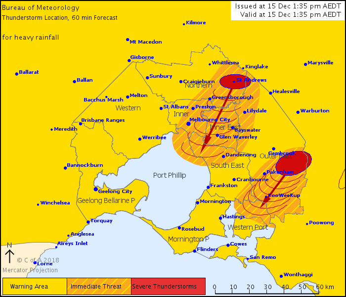
Severe Thunderstorm Warning - Melbourne Area
for HEAVY RAINFALL
For people in Inner East, Inner and parts of Port Phillip waters, Western Port, South East, Northern and Outer East Local Warning Areas.
Issued at 1:35 pm Saturday, 15 December 2018.

The Bureau of Meteorology warns that, at 1:35 pm, severe thunderstorms were detected on the weather radar near the area northeast of Pakenham, the area south of Kinglake and the area east of Pakenham. They are forecast to affect Greensborough, Pakenham and Ringwood by 2:05 pm and Caulfield, Dandenong, Glen Waverley and Melbourne City by 2:35 pm.

Heavy rainfall that may lead to flash flooding is likely.
stw151218.png
stw151218.png (79.84 KiB) Viewed 7246 times
Jake - Senior AWF Forecaster
Feel free to send me a private message if you have any questions.
w
weathergasm
Cumulonimbus
Reactions:
Posts: 244
Joined: Sun Feb 14, 2010 9:32 pm
Location: Box Hill

Re: Major upper and surface lows 12–16 Dec

Post by weathergasm »

That Kinglake cell looks as though it is taking a more southerly turn than the rest of the storms in the cluster, could give an absolute smashing to the inner eastern suburbs if it maintains intensity.👌
J
JasmineStorm
Supercell
Reactions:
Posts: 1870
Joined: Thu Sep 22, 2016 9:40 pm
Location: Kyneton 527 ASL

Re: Major upper and surface lows 12–16 Dec

Post by JasmineStorm »

I love it when it all comes together :)
J
James
Supercell
Reactions:
Posts: 1059
Joined: Wed Nov 25, 2009 6:10 pm
Location: Boronia

Re: Major upper and surface lows 12–16 Dec

Post by James »

finally hearing some random rumblings!! - and its not my stomach!
t
tonycynic
Cumulonimbus
Reactions:
Posts: 494
Joined: Tue Feb 15, 2011 5:57 pm
Location: Mount Evelyn (h),Donvale (w)

Re: Major upper and surface lows 12–16 Dec

Post by tonycynic »

Rumbles in Mount Evelyn. Looking like it is a little north of us but close enough. Wind picking up and getting dark. Here it comes again.
J
Jezza
Cumulus
Reactions:
Posts: 27
Joined: Fri Dec 14, 2018 7:49 pm
Location: Balwyn, Victoria

Re: Major upper and surface lows 12–16 Dec

Post by Jezza »

Long time reader, first time poster.

The rain has just arrived here in Balwyn.
D
Dane
Supercell
Reactions:
Posts: 1661
Joined: Thu Nov 26, 2009 9:51 am
Location: Sebastopol 420m ASL
Contact:

Re: Major upper and surface lows 12–16 Dec

Post by Dane »

Finally hearing some thunder from the cell to my east. First thunder I have heard from this system.
Worried that it may just slide to the soutrh of me. Will know soon.
Locked