Karl Lijnders wrote:Nice roll cloud as it came across. Pity no storm attached.
Should see a further 5mm over southern areas. 20-50mm over the north and northeast.
Welcome New Members! We want to hear from you. Register, stop lurking and start posting!
Victoria: Rain/storm event - 6th-10th December 2010 (Obs)
- wolfcat
- Cumulonumbus Calvas
- Reactions:
- Posts: 562
- Joined: Sun Mar 07, 2010 12:14 pm
- Location: Bentleigh East
- Contact:
Re: Victoria: Rain/storm event - 6th-10th December 2010 (Obs
other places you will find me...
My blog...http://www.wolfcat.com.au/randomrants/
Flickr .. http://www.flickr.com/photos/wolfcat_aus/
Twitter... http://twitter.com/wolfcat
Redbubble... http://www.redbubble.com/people/wolfcat
My blog...http://www.wolfcat.com.au/randomrants/
Flickr .. http://www.flickr.com/photos/wolfcat_aus/
Twitter... http://twitter.com/wolfcat
Redbubble... http://www.redbubble.com/people/wolfcat
- droughtbreaker
- Supercell
- Reactions:
- Posts: 2844
- Joined: Wed Nov 25, 2009 7:50 pm
- Location: Mount Macedon, VIC, 520m asl
Re: Victoria: Rain/storm event - 6th-10th December 2010 (Obs
GFS was right in the run, last night i think it was, when it had the heavy rain in the west and north east of the state bypassing central areas. 22.5mm here since yesterday evening. A fair bit of that was before 9am as there were some heavy showers here at 7am.
BOM went down the wrong path IMO with their 'widespread heavy rain' forecast for Melbourne and the entire state. The heavy rain was not widespread over the whole state. Really it should have been 'rain areas with the chance of thunderstorms'. Often BOM go a bit too general with their forecasts. Anyway another fairly heavy shower affecting us here atm so not completely over yet.
BOM went down the wrong path IMO with their 'widespread heavy rain' forecast for Melbourne and the entire state. The heavy rain was not widespread over the whole state. Really it should have been 'rain areas with the chance of thunderstorms'. Often BOM go a bit too general with their forecasts. Anyway another fairly heavy shower affecting us here atm so not completely over yet.
- Petethemoskeet
- Cumulonimbus
- Reactions:
- Posts: 272
- Joined: Mon Mar 08, 2010 1:06 pm
- Location: Toowoomba
Re: Victoria: Rain/storm event - 6th-10th December 2010 (Obs
Some very heavy showers moving through in the last hour at last with most of the good stuff staying just west of us all afternoon.Maybe the system is finally starting to move east.Few roads around the area cut by flash flooding mainly being the Yach to Wodonga and Beechworth to Wodonga.
- Anthony Violi
- Supercell
- Reactions:
- Posts: 2652
- Joined: Mon Nov 23, 2009 9:03 pm
- Location: Lilydale
- Contact:
Re: Victoria: Rain/storm event - 6th-10th December 2010 (Obs
Yes it looks like our chance for a big clear air storm is gone for Melbourne, unless one goes on the back of this band but not likely.
Still looks like we will see mid level deck stuff for the next few hours, as Karl said 5mm or so. The weather gods just werent with us today, but i have had 63mm since last Wednesday so no complaints here.
The beauty is the dams are copping a pasting, Marysville is almost cracked the ton which is in Upper Yarra territory. And Eildon the same, with much more to come from thunderstorms tonight.
Edit: Mid level deck starting to look very convective, might start to drop some decent stuff soon as its getting progressively black outside.
Last edited by Anthony Violi on Wed Dec 08, 2010 5:46 pm, edited 1 time in total.
http://www.therealworldweatherforum.com" onclick="window.open(this.href);return false;
avweatherforecasts.com
avweatherforecasts.com
- droughtbreaker
- Supercell
- Reactions:
- Posts: 2844
- Joined: Wed Nov 25, 2009 7:50 pm
- Location: Mount Macedon, VIC, 520m asl
Re: Victoria: Rain/storm event - 6th-10th December 2010 (Obs
Interesting, very heavy shower at the moment showing dark blue on radar.  Something a bit odd there.
- stratospear
- Supercell
- Reactions:
- Posts: 1261
- Joined: Sat Dec 19, 2009 9:38 am
- Location: Usually Bendigo
Re: Victoria: Rain/storm event - 6th-10th December 2010 (Obs
Looks like one last hurrah for us in the coming hour or two. Substantial "blob" showing up on radar and satpic to our NW. It'll be interesting to see if it has any grunt left in it or goes bananas with a bit of uplift. I suspect it's going to run out of steam, but could be wrong.
- Anthony Violi
- Supercell
- Reactions:
- Posts: 2652
- Joined: Mon Nov 23, 2009 9:03 pm
- Location: Lilydale
- Contact:
Re: Victoria: Rain/storm event - 6th-10th December 2010 (Obs
Yeah its starting to go now, very dark outside. Looks like another line forming as a carbon copy of this morning. Eastern Central areas and North Central could cop another decent smacking by the looks.
http://www.therealworldweatherforum.com" onclick="window.open(this.href);return false;
avweatherforecasts.com
avweatherforecasts.com
- Monbulkian
- Cumulonimbus
- Reactions:
- Posts: 192
- Joined: Thu Nov 11, 2010 9:42 pm
- Location: Monbulk
- brayden
- Cumulonimbus
- Reactions:
- Posts: 225
- Joined: Thu Dec 31, 2009 9:54 am
- Location: Perth. Originally Wodonga, Vic
Re: Victoria: Rain/storm event - 6th-10th December 2010 (Obs
Yeah not much in the way of epic storms just alot of rain, sorry anthony game over lol
Just got a call from the mother in Wodonga, road shut as Huon Creek going over the top of the bridge at huon creek rd.
Just got a call from the mother in Wodonga, road shut as Huon Creek going over the top of the bridge at huon creek rd.
"I'm in with the sane, does that make me Insane?"
"I lycra like that"
"I lycra like that"
- Petros
- Supercell
- Reactions:
- Posts: 2009
- Joined: Tue Dec 01, 2009 6:25 pm
- Location: Maffra, Gippsland, Vic
Re: Victoria: Rain/storm event - 6th-10th December 2010 (Obs
Weather arrived as a nice storm in Maffra mid arvo and has delivered 21.5mm, and if we can keep that below 30mm by the end of the night it would be perfect 

Comiserations to those out in the W and N & NE who are being devestated by flooding.
...... a land of droughts and flooding rain, I guess we all knew the drought would end this way (at least us oldies did).
Comiserations to those out in the W and N & NE who are being devestated by flooding.
...... a land of droughts and flooding rain, I guess we all knew the drought would end this way (at least us oldies did).
- mick
- Supercell
- Reactions:
- Posts: 1453
- Joined: Mon Nov 30, 2009 6:45 pm
- Location: Mid North SA Baaaaaaaaaaaaaaa
Re: Victoria: Rain/storm event - 6th-10th December 2010 (Obs
Watched the roll cloud over the bay from 4.30 to 5.30. At 4.30 it had 6 lowerings of scud from it up the brighton end, stretching to Aspendale.. One formed a rope extending 1/4 way to the water, nice and fat, perfect shape, then it went as thin as a pencil, faded, came back for a few more seconds then vanished. The other 5 lowerings although the classic V shape, did not develop. It all headed the same direction as last week towards aspendale gardens. Slight greenage visible, it was so low, down to abt 100 ft I reckon.
No wind to speak of again, flat as the proverbial on the bay atm. Still plenty chunky clouds down here, dont think its over.
No wind to speak of again, flat as the proverbial on the bay atm. Still plenty chunky clouds down here, dont think its over.
- greensyboy
- Cumulus
- Reactions:
- Posts: 73
- Joined: Sun Mar 07, 2010 7:42 pm
- Location: Forest Hill
Re: Victoria: Rain/storm event - 6th-10th December 2010 (Obs
Amazing cloud coming up off the bay.
Went past Windy Hill on the way home to take some snaps, good timing as a Leader Newspaper photographer arrived. He took some snaps of the approaching cloud, then wanted some of me taking photos. Could turn out to be a good birthday present next Wednesday, picture in the local paper!
Anyway, here are some that I took from the hill (shrunk them a little bit for those without broadband, no one seems to be posting in the images thread):
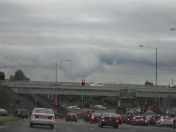
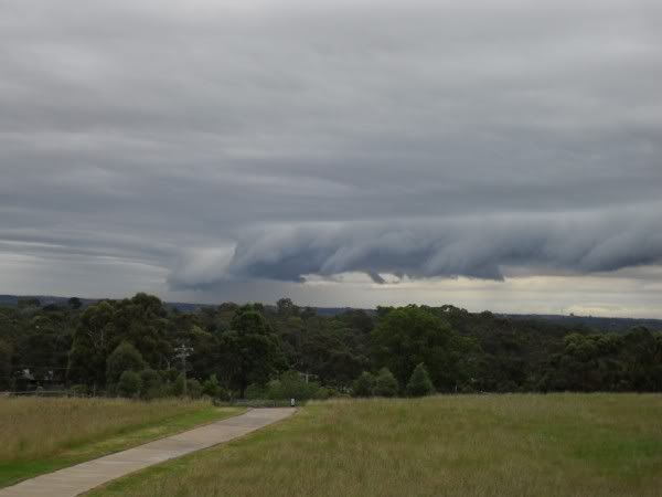
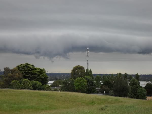


Severe Weather Enthusiast
- stratospear
- Supercell
- Reactions:
- Posts: 1261
- Joined: Sat Dec 19, 2009 9:38 am
- Location: Usually Bendigo
Re: Victoria: Rain/storm event - 6th-10th December 2010 (Obs
All over here. Latest "blob" just missed us, now clearing from the west and much cooler.
Re: Victoria: Rain/storm event - 6th-10th December 2010 (Obs
Hoseing down here!! Heavy and thick as! At one stage couldn't see anything past 100 metres! Good 5mm in the past 5mins here!
- Anthony Violi
- Supercell
- Reactions:
- Posts: 2652
- Joined: Mon Nov 23, 2009 9:03 pm
- Location: Lilydale
- Contact:
Re: Victoria: Rain/storm event - 6th-10th December 2010 (Obs
North East on track for another smashing, going to be a huge rain band through there with heavy falls.
Kudos to the models who had this event spot on, heaviest through the west and North/East.
Kudos to the models who had this event spot on, heaviest through the west and North/East.
http://www.therealworldweatherforum.com" onclick="window.open(this.href);return false;
avweatherforecasts.com
avweatherforecasts.com
- Petethemoskeet
- Cumulonimbus
- Reactions:
- Posts: 272
- Joined: Mon Mar 08, 2010 1:06 pm
- Location: Toowoomba
Re: Victoria: Rain/storm event - 6th-10th December 2010 (Obs
Mt Hotham up to 55mls.If that figure is doubled overnight the Ovens river will be in Major flood by the morning and cause big problems in Bright and Myrtleford
- I_Love_Storms
- Supercell
- Reactions:
- Posts: 2812
- Joined: Wed Dec 02, 2009 2:01 pm
- Location: Hawthorn
Re: Victoria: Rain/storm event - 6th-10th December 2010 (Obs
Hammering down in Wantirna South and Heathmont before. Must have been very localised but would have been very high intensity rainfall and equated to around orange on the radar. Terrible driving conditions out there, can't believe BOM took down the Road Weather Alert! What morons...honestly
- Petros
- Supercell
- Reactions:
- Posts: 2009
- Joined: Tue Dec 01, 2009 6:25 pm
- Location: Maffra, Gippsland, Vic
Re: Victoria: Rain/storm event - 6th-10th December 2010 (Obs
Just steady rain here, continuous since the aforementioned storms, can see a band of about 50KM of the "green" BOM radar rain rate about to hit us from the NW. The greenkeepers at the golf club wont be happy ("too much" rain) and the wier keeper at Lake Glenmaggie will be pacing about, the dam is still spilling (albiet at low rate) since the last event 8 days ago - he would be getting nervous.
And as I type, the rain rate has lifted from light/steady to medium/steady rain.


And as I type, the rain rate has lifted from light/steady to medium/steady rain.
- occluded
- Cumulonumbus Calvas
- Reactions:
- Posts: 611
- Joined: Tue May 04, 2010 3:26 pm
- Location: Mooroolbark 130m asl
Re: Victoria: Rain/storm event - 6th-10th December 2010 (Obs
Coming down nicely in Springvale Rd, Nunawading. Nice big sheets of rain, perhaps the last hurrah for this event?!
- Duckey
- Cumulonimbus
- Reactions:
- Posts: 283
- Joined: Sun Mar 07, 2010 3:39 pm
- Location: Live: Croydon Work: Burwood
Re: Victoria: Rain/storm event - 6th-10th December 2010 (Obs
So bizarre....it's absolutely torrential rain here at the moment, but not showing up on radar! The rain's so heavy it's leaking in all around our study window! 
Storm Nerd!!
