
Welcome New Members! We want to hear from you. Register, stop lurking and start posting!
VIC Fronts with rain & storms then showers: 26/9/-01/10
-
Supercellimpact

- Supercell
- Reactions:
- Posts: 1238
- Joined: Thu Oct 07, 2010 8:39 pm
- Location: Bendigo
Re: VIC Fronts with rain & storms then showers: 26/9/-01/10
So I'm in bed and BANG ! Wakes me up lol... It's going to be a crazy day guys !!
- Twister
- Cumulonumbus Calvas
- Reactions:
- Posts: 914
- Joined: Sun Nov 29, 2009 10:47 pm
- Location: Brisbane Qld
Re: VIC Fronts with rain & storms then showers: 26/9/-01/10
Yep storms now exploding over and E of Mildura as it runs into better moisture this will continue to explode in the coming hours storms also going up in the rain band to our north
This rain band will help up Dps before trough moves in later today
Big day up north and lots of heavy rain for us later today
This rain band will help up Dps before trough moves in later today
Big day up north and lots of heavy rain for us later today
Now Living in Wet QLD
- adon
- Cumulonumbus Calvas
- Reactions:
- Posts: 681
- Joined: Wed Dec 09, 2009 12:50 pm
- Location: Birchip NW Vic
Re: VIC Fronts with rain & storms then showers: 26/9/-01/10
First storm through home but only a bit over a mm in it.  Exactly where IS the change???? I thought it was the line aproaching adelade now but storm tracker showing northerlies after it so is it the line of showers/storms in the bight?
- Twister
- Cumulonumbus Calvas
- Reactions:
- Posts: 914
- Joined: Sun Nov 29, 2009 10:47 pm
- Location: Brisbane Qld
Re: VIC Fronts with rain & storms then showers: 26/9/-01/10
Yep that's the main front in the bight so before then many bands of showers and storms to come
Line E of Mildura is just erupting really beefing up and Very lightening active
Big day I am Excited
Line E of Mildura is just erupting really beefing up and Very lightening active
Big day I am Excited
Now Living in Wet QLD
-
stratospear

- Supercell
- Reactions:
- Posts: 1261
- Joined: Sat Dec 19, 2009 9:38 am
- Location: Usually Bendigo
Re: VIC Fronts with rain & storms then showers: 26/9/-01/10
Thunder about every 30 seconds, rain has commenced. It could get really interesting if we get clear air after this! I suspect Echuca might be the real hot spot for supercell action later.
Close lightning strike just then.
Close lightning strike just then.
- I_Love_Storms
- Supercell
- Reactions:
- Posts: 2812
- Joined: Wed Dec 02, 2009 2:01 pm
- Location: Hawthorn
Re: VIC Fronts with rain & storms then showers: 26/9/-01/10
Convection getting going over the bay now.
-
Tornado

- Cumulus
- Reactions:
- Posts: 93
- Joined: Wed Feb 24, 2010 12:04 pm
- Location: Strathfieldsaye, Bendigo, Victoria
Re: VIC Fronts with rain & storms then showers: 26/9/-01/10
stratospear » Wed Sep 28, 2011 10:30 am wrote:stratospear wrote:Thunder about every 30 seconds, rain has commenced. It could get really interesting if we get clear air after this! I suspect Echuca might be the real hot spot for supercell action later.
Close lightning strike just then.
VERY CLOSE!
He strolls up to the twister, and he says, *have a drink*. And he chucks the bottle into the twister, and it never hits the ground.
-
Karl Lijnders

- Tornadic Supercell
- Reactions:
- Posts: 5771
- Joined: Sun Nov 22, 2009 11:17 pm
- Location: Knoxfield, Victoria
Re: VIC Fronts with rain & storms then showers: 26/9/-01/10
Really cranking up behind the stuff over Bendigo so I think this is just the entree.
Should be seeing showers and thunder moving into Melbourne by 11am - with rain increasing for a period. The main action gets going after 1pm today over parts of the Mallee, Wimmera and Western areas. The trough is very slow and will stall over Melbourne tonight.
Here is how it is looking coming in from the north.
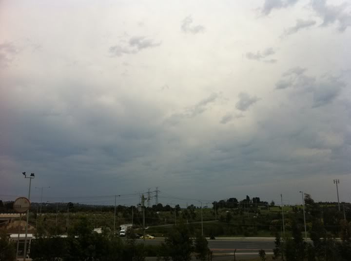
Former Owner - The Australian Weather Forum. Email me anytime - weatherman1000@hotmail.com
- GregSorenson2
- Cumulus
- Reactions:
- Posts: 68
- Joined: Thu Sep 16, 2010 11:08 pm
Re: VIC Fronts with rain & storms then showers: 26/9/-01/10
I agree, only an entree'. If you look at the vis sat, the clean air further north will allow of far more heating. The timing is perfect for supercells to the north - the sheer profile is spot on. Expect some interesting features extending under some of these beasts. If i were chasing i'd hug the back end with discreet super cells with complete isolation in open air. Stay away from the muck!
http://realtime2.bsch.au.com/vis_sat2.h ... &stop=#nav" onclick="window.open(this.href);return false;
http://realtime2.bsch.au.com/vis_sat2.h ... &stop=#nav" onclick="window.open(this.href);return false;
Re: VIC Fronts with rain & storms then showers: 26/9/-01/10
G'day
Sounds good Karl.
I'm listening to am radio today and the usual cracking when a storm approaches started about 10 minutes ago, getting cracks about 1 in 2 minutes. Radar starting to thicken up but I'm not getting to excited here just yet as it always hits the hills behind the marsh and just stops.
Hoping it does what it did back in Jan here when we had a cracker come from the northwest over the hills and dumped 5mm in 10 mins.
Cheers
- HarleyB
- Cumulonumbus Calvas
- Reactions:
- Posts: 839
- Joined: Sun Oct 10, 2010 9:39 pm
- Location: Wangaratta
Re: VIC Fronts with rain & storms then showers: 26/9/-01/10
Already starting to turn nasty here, rain in the air, should start in the next 10 minutes or so. Wind gusts are bordering on damaging here just now. It's all about to kick off for us
- tonycynic
- Cumulonimbus
- Reactions:
- Posts: 494
- Joined: Tue Feb 15, 2011 5:57 pm
- Location: Mount Evelyn (h),Donvale (w)
Re: VIC Fronts with rain & storms then showers: 26/9/-01/10
BOM have put out a severe thunderstorm warning at last.
SEVERE THUNDERSTORM WARNING
for DAMAGING WIND
For people in the Mallee, Northern Country, Wimmera and parts of the Central, North Central and North East Forecast Districts.
Issued at 9:56 am Wednesday, 28 September 2011.
Severe thunderstorms are likely to produce damaging winds in the warning area over the next several hours. Locations which may be affected include Mildura, Horsham, Bendigo, Shepparton, Seymour, Maryborough, Wodonga and Wangaratta.
Thunderstorms are currently scattered across northern Victoria. Damaging wind gusts with the thunderstorms are a possibility due to significant shear; strong winds have been observed above the surface this morning with Melbourne recording 60kts at 1500ft and Mildura recording 50kt at 5000ft. Thunderstorms are expected to extend to areas in the south of the state throughout the day.
- GregSorenson2
- Cumulus
- Reactions:
- Posts: 68
- Joined: Thu Sep 16, 2010 11:08 pm
Re: VIC Fronts with rain & storms then showers: 26/9/-01/10
I can't remember a time when they've added detailed relating to the wind shear in a warning. All us weather nuts know about it of course, however it's good to see that the BOM are adding these details for the wider public.
- Harley34
- Cumulonumbus Calvas
- Reactions:
- Posts: 580
- Joined: Sat Mar 06, 2010 1:08 pm
- Location: Ringwood East, Melbourne
Re: VIC Fronts with rain & storms then showers: 26/9/-01/10
So that line east of Mildura, why is that so lightning active?
There must be an abundance of pulse thunderstorm cells amongst the patchy rain..correct me if I am wrong.
Looks like to me in the next hour or so, Melbourne should hear some rumbles. By the way guys, is there a rain shadow, or thunderstorm shield out today?
There must be an abundance of pulse thunderstorm cells amongst the patchy rain..correct me if I am wrong.
Looks like to me in the next hour or so, Melbourne should hear some rumbles. By the way guys, is there a rain shadow, or thunderstorm shield out today?
Re: VIC Fronts with rain & storms then showers: 26/9/-01/10
Still looking like a very real threat of big hail and microbursts/strong gusts for NNW Vic and inland NSW.
There's favourable ingredients for hail - an impressive amount of hail CAPE (the amount of CAPE in the hail growth zone, typically between around 300 and 600hpa), wetbulb freezing levels in the favourable range and some dry slots in the midlevels. Also looks favourable for strong gusts - some dry'ish air in the low levels which should act to further cool and accelerate air being dragged downwards from under storms and strong winds aloft being dragged down in storms also.
However this largely depends on where some of the current cloudcover and precip can clear early enough to allow a bit of surface heating to help instability along.
Last edited by Ken on Wed Sep 28, 2011 10:43 am, edited 2 times in total.
- Jake Smethurst
- Supercell
- Reactions:
- Posts: 3583
- Joined: Mon Nov 23, 2009 8:49 pm
- Location: Cheltenham
Re: VIC Fronts with rain & storms then showers: 26/9/-01/10
Currently in the process of issuing our thunderstorm charts for the rest of today. Quite a bit of detail in it today do apologise in advance, will posted shortly. Otherwise its gradually climbing temperature wise here, 16/11, still expecting it climb higher this afternoon. Some very nice thunderstorms already developed which is good to see, more will this afternoon.
Jake - Senior AWF Forecaster
Feel free to send me a private message if you have any questions.
Feel free to send me a private message if you have any questions.
- norwester
- Cumulonimbus
- Reactions:
- Posts: 105
- Joined: Sat Feb 05, 2011 9:54 am
- Location: Merbein, Vic
Re: VIC Fronts with rain & storms then showers: 26/9/-01/10
Big wind gusts up here in Mildura and a couple of claps of thunder earlier but nothing exciting and no rain. That big line of storms seems to avoided us looking at the radar . Its been mostly sunny with some light to moderate cloud cover this morning.
Dry, dusty and hot - usually!
-
Karl Lijnders
- Tornadic Supercell
- Reactions:
- Posts: 5771
- Joined: Sun Nov 22, 2009 11:17 pm
- Location: Knoxfield, Victoria
Re: VIC Fronts with rain & storms then showers: 26/9/-01/10
Yeah because the potential today for destructive winds is very high given the environment.
Mildura warming quickly, up 4C in the last half hour or so.
Few storms at the southern end of the bay as well now - here is a view looking in that direction to the back edge of the precip. Looking volitile.
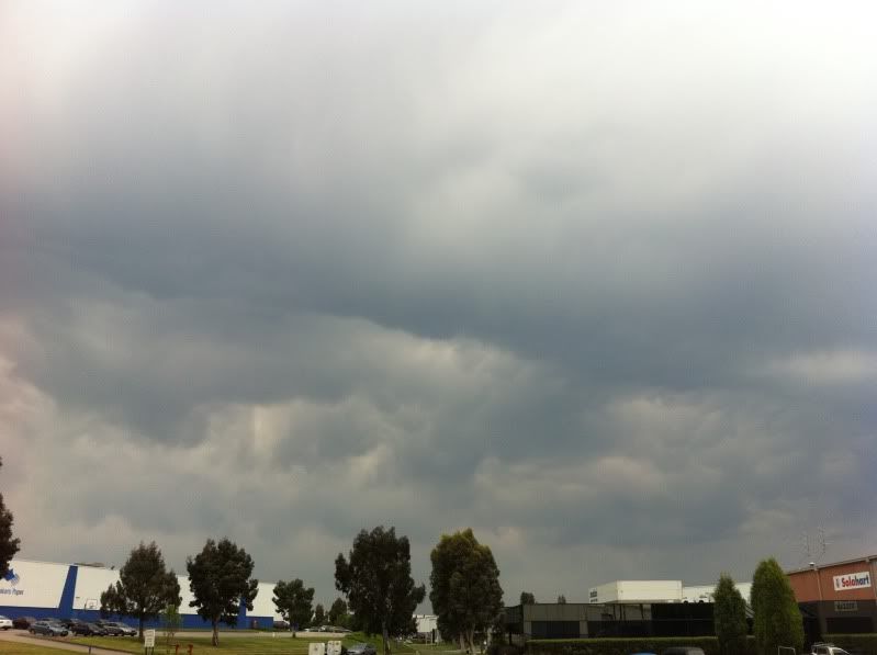
Mildura warming quickly, up 4C in the last half hour or so.
Few storms at the southern end of the bay as well now - here is a view looking in that direction to the back edge of the precip. Looking volitile.
Former Owner - The Australian Weather Forum. Email me anytime - weatherman1000@hotmail.com
- Jake Smethurst
- Supercell
- Reactions:
- Posts: 3583
- Joined: Mon Nov 23, 2009 8:49 pm
- Location: Cheltenham
Re: VIC Fronts with rain & storms then showers: 26/9/-01/10
Apologies for the reading amount.
Thunderstorm Forecast - Day 1 (Wednesday)
Issued 10:30 AM EST 28/09/2011
A trough of low pressure and an advancing frontal feature will be responsible for thunderstorm development today across Victoria. All variables for thunderstorm development are very healthy across the state today. Morning soundings and forecast soundings show widespread instability with the Convective Available Potential Energy (CAPE) rising signficantly during the day across the entire western half of Victoria, with Lifted Index values approaching -6 or -7 widespread. The moisture profile is also very good, with surface dew points expected to be generally between 12-16 degrees, particularly during the afternoon. The upper profile of the amosphere in regards to temperatures is also supportive of good thunderstorm development with colder air-aloft. Currently scattered thunderstorms are occurring across northern Victoria. Otherwise, for the remainder of this morning and this afternoon and evening, scattered thunderstorms are likely across all areas of Victoria, however they are more likely in the western and central districts (Mallee, Wimmera, Southwest, Northern Country, North Central, Central) where the strongest variables for development exist, and also in any clearer air that becomes available. Severe activity in thunderstorms is highly likely in the area defined below; forecast models are indicating ample outflow of 60-90 knots (at 300mb) and reasonable inflow of about 10 knots ( at surface), with other shear levels indicating the potential for destructive winds. Supercell thunderstorms will be possible in the 'severe' area marked below with 0-6km shear showing a nice 90-degree shift in direction from the surface to 500mb and good strength. 0-1km shear levels are also looking good, thus tornadoes cannot be rulled out in any supercell formation. Supercells are particularly likely over the Northern Central region around Echuca stretching south towards Bendigo, and also around the region of the southeast Mallee. Flash flooding is also partcularly likely thanks to the large amount of moisture available, and large hailstones will also be a risk in any thunderstorms thanks to the cold uppers. The thunderstorms currently occurring are expected to clear eastwards during the day, allowing for ample oppurtunity for thunderstorms to redevelop in the west and spread southeast this afternoon and evening. There are also some indications that if a large enough band of thunderstorms develop, they will tend into areas of thundery rain as they move southeast into central Victoria late today and tonight. As of 9.56am the Bureau of Meteorology had issued a Severe Thunderstorm Warning for parts of Victoria. **A reminder this chart is not official. Updates of this chart will be provided this afternoon and evening.
Jake - Senior AWF Forecaster
Feel free to send me a private message if you have any questions.
Feel free to send me a private message if you have any questions.
Re: VIC Fronts with rain & storms then showers: 26/9/-01/10
G'day
Is it just me or is it staying north of the hills around Melbourne
Cheers
Is it just me or is it staying north of the hills around Melbourne
Cheers