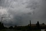
If good storms threaten the Melbourne area this arvo I may head up to SkyHigh Mount Dandenong to get some photos, hope there's lots of lightning today like last week's storm, that was a fun performance

Welcome New Members! We want to hear from you. Register, stop lurking and start posting!
VIC - Showers & Possible Storms Oct 5-9 2011
- aussiestormfreak
- Cumulonumbus Calvas
- Reactions:
- Posts: 534
- Joined: Thu Feb 03, 2011 9:52 am
- Location: Melbourne, Corryong, Merimbula, and Fiji
- Contact:
Re: VIC - Showers & Possible Storms Oct 5-9 2011
Well the fog has largely disappeared now, but I've now got a layer of altocumulus drifting overhead... need more sunshine please lol 
If good storms threaten the Melbourne area this arvo I may head up to SkyHigh Mount Dandenong to get some photos, hope there's lots of lightning today like last week's storm, that was a fun performance
If good storms threaten the Melbourne area this arvo I may head up to SkyHigh Mount Dandenong to get some photos, hope there's lots of lightning today like last week's storm, that was a fun performance

Re: VIC - Showers & Possible Storms Oct 5-9 2011
Nice Rikki! Been a while since we've seen convection like today.
Just hope it holds it in for a few more hours and then bam when i get outta work!
Just hope it holds it in for a few more hours and then bam when i get outta work!
Re: VIC - Showers & Possible Storms Oct 5-9 2011
G'day
Well I watched the storms build all day round the marsh yesterday and finally let go just as I was heading home at 4.30. Today I'm doing my truck license in Altona and driving up on too the western ring from the west gate you can see the build up over the hills towards macedon.
I missed the storm in Coldstream as I was at work.
Hopefully today it will start when I'm at home. It does feel really humid and reminds me alot of last year.
Cheers
Re: VIC - Showers & Possible Storms Oct 5-9 2011
nice shot Rikki...hard to see any development in Melb due to total cloud cover around CBD
- I_Love_Storms
- Supercell
- Reactions:
- Posts: 2812
- Joined: Wed Dec 02, 2009 2:01 pm
- Location: Hawthorn
Re: VIC - Showers & Possible Storms Oct 5-9 2011
It looks like Hong Kong or Singapore outside. A misty humid haze is lingering around the CBD.
Re: VIC - Showers & Possible Storms Oct 5-9 2011
Nice Rikki, looks like theres a building somewhere behind on fire!
I think we will be looking at an explosion of cells between now and 3. Interesting arvo ahead hey.
Tropical feel outside, dead calm here. The sun has a bit of sting in it now.
I think we will be looking at an explosion of cells between now and 3. Interesting arvo ahead hey.
Tropical feel outside, dead calm here. The sun has a bit of sting in it now.
-
flatcam

- Cumulonimbus
- Reactions:
- Posts: 182
- Joined: Wed Jan 05, 2011 8:16 pm
- Location: Craigieburn, Victoria
Re: VIC - Showers & Possible Storms Oct 5-9 2011
Very still outside here at the moment. The cell near Sunbury looks much worse than what the radar indicates - but then again, I can't see the base due to houses being in my way! It's very dark and I can make out some nice features in it. Hopefully it doesn't break apart before it gets here.
It looks as if I will be in the firing line for these cells for a while! Looking forward to it!
Cheers, Cam
It looks as if I will be in the firing line for these cells for a while! Looking forward to it!
Cheers, Cam
-
Rivergirl

- Memorial
- Reactions:
- Posts: 3674
- Joined: Sun Nov 22, 2009 6:04 pm
- Location: Ferny Creek VIC
- Contact:
Re: VIC - Showers & Possible Storms Oct 5-9 2011
aussiestormfreak, a good place to go instead of Sky High is Ridge Road Kallista. It's free and closer to you. You drive a couple of kms along it until you get to a viewing area on the right with sweeping views to the south and west. The other side of the road looks to the east.
- aussiestormfreak
- Cumulonumbus Calvas
- Reactions:
- Posts: 534
- Joined: Thu Feb 03, 2011 9:52 am
- Location: Melbourne, Corryong, Merimbula, and Fiji
- Contact:
Re: VIC - Showers & Possible Storms Oct 5-9 2011
Hey Rivergirl!Rivergirl » Fri Oct 07, 2011 1:51 pm wrote:Rivergirl wrote:aussiestormfreak, a good place to go instead of Sky High is Ridge Road Kallista. It's free and closer to you. You drive a couple of kms along it until you get to a viewing area on the right with sweeping views to the south and west. The other side of the road looks to the east.
Yes I've been to Ridge Road on numerous occasions, it's a great spot, went up there a few times last month, thanks again for reminding me
The trouble with Ridge Road though is that there are very limited views towards the west and in particular the northwest, so SkyHigh Mount Dandenong is a preferred option if you want to look in those directions. However, Ridge Road offers great views over the Southeast Suburbs and the Yarra Valley.
Thanks again for mentioning Ridge Road. Btw Rivergirl, have you ever been along Glenfern Road in Upwey/Upper Ferntree Gully? There are a number of stopping areas on the south side of the road, great views towards the southwest! I was there last week on Wednesday when that big squall line came through Melbourne, managed to film a large handful of nasty CGs. If you haven't been along that road, perhaps you might like to sometime
-
Rivergirl
- Memorial
- Reactions:
- Posts: 3674
- Joined: Sun Nov 22, 2009 6:04 pm
- Location: Ferny Creek VIC
- Contact:
Re: VIC - Showers & Possible Storms Oct 5-9 2011
Good, glad you know about it. I reckon its a great place to photograph the aurora if we ever get a geomagnetic storm duirng the night. I photographed the lunar eclipse there. Yes I love Glenfern Road, Upwey. I have gone over there many times to photograph sunsets. Will have to keep it in mind for photographing storms
- rikjpool
- Storm Chaser
- Reactions:
- Posts: 989
- Joined: Thu Nov 26, 2009 1:46 pm
- Location: Home: North Bendigo-just behind Lake Weeroona, Vic. Work: 1.5Km SE from Bendigo AWS
Re: VIC - Showers & Possible Storms Oct 5-9 2011
some interesting returns on that cell near sunbury!
I live in a world where I dont see to believe, but I believe to see...
-
Karl Lijnders

- Tornadic Supercell
- Reactions:
- Posts: 5771
- Joined: Sun Nov 22, 2009 11:17 pm
- Location: Knoxfield, Victoria
Re: VIC - Showers & Possible Storms Oct 5-9 2011
Yeah it's tiny but moving almost south now into the seabreeze. Hope it can destabalise the region around it and get other cells firing. Might be touch and go for Melbourne but still a long way to go.
Former Owner - The Australian Weather Forum. Email me anytime - weatherman1000@hotmail.com
-
flatcam
- Cumulonimbus
- Reactions:
- Posts: 182
- Joined: Wed Jan 05, 2011 8:16 pm
- Location: Craigieburn, Victoria
Re: VIC - Showers & Possible Storms Oct 5-9 2011
Here's a quick shot I took of the Sunbury cell before. I think it may have been dying out here though but you can still see a bit of a rainshaft to the right of the image.
Please let me know if you are unable to see the full size image through the thumbnail. I'm not sure if it worked or not.
Cheers, Cam

Please let me know if you are unable to see the full size image through the thumbnail. I'm not sure if it worked or not.
Cheers, Cam
-
AUSSKY

- Storm Chaser
- Reactions:
- Posts: 538
- Joined: Wed Nov 25, 2009 11:59 pm
- Location: Trentham (700m ASL)
- Contact:
Re: VIC - Showers & Possible Storms Oct 5-9 2011
Some deep convection over the past two hours around the central ranges Vic.....the first thunder at 1435 to the southeast and a second one at 1438. looks like a pulsy cell southeast of Blackwood...crap chase country Clyve H
Australian Sky & Weather (AUSSKY)
Victoria - The State of Drizzle & Occasional Tornadoes
(1999 -2016)
Victoria - The State of Drizzle & Occasional Tornadoes
(1999 -2016)
- Stone Free
- Cumulus
- Reactions:
- Posts: 25
- Joined: Tue Dec 15, 2009 9:01 am
- Location: Reservoir, Victoria
Re: VIC - Showers & Possible Storms Oct 5-9 2011
Karl Lijnders » Fri Oct 07, 2011 2:20 pm wrote:Karl Lijnders wrote:Yeah it's tiny but moving almost south now into the seabreeze. Hope it can destabalise the region around it and get other cells firing. Might be touch and go for Melbourne but still a long way to go.
Pretty sure the sea breeze will kill off anything south of Whittlesea. Such a shame.
-
Karl Lijnders
- Tornadic Supercell
- Reactions:
- Posts: 5771
- Joined: Sun Nov 22, 2009 11:17 pm
- Location: Knoxfield, Victoria
Re: VIC - Showers & Possible Storms Oct 5-9 2011
Actually more of a chance out there SF than further south. Your chance will come after 4pm.
Thanks for the update Clyve. I wonder how long it will be before bigger cells emerge? They are having a crack on the C ranges no doubt.
Thanks for the update Clyve. I wonder how long it will be before bigger cells emerge? They are having a crack on the C ranges no doubt.
Former Owner - The Australian Weather Forum. Email me anytime - weatherman1000@hotmail.com
- I_Love_Storms
- Supercell
- Reactions:
- Posts: 2812
- Joined: Wed Dec 02, 2009 2:01 pm
- Location: Hawthorn
Re: VIC - Showers & Possible Storms Oct 5-9 2011
She'll be right. Agree with Karl. I reckon by 4pm should have some nice heavy stuff coming through CBD.
- Hamlan
- Storm Chaser
- Reactions:
- Posts: 449
- Joined: Tue Dec 22, 2009 11:05 pm
- Location: Northern suburbs
Re: VIC - Showers & Possible Storms Oct 5-9 2011
glad someone noticed! I was on that cell just west of Sunbury and can report rotation and a small funnel approx 2.15pm. Unfortunately I havent got my camera or video at work with me today but was lucky enough to be near the airport when I noticed the storm structure (albiet a small cell) and obvious southerly motion against the flow. At this stage I thought there were signs of outflow dominance and a line segment developing however the main cell strengthened and low fractus was being drawn up rapidly as I watched from the eastern side of the airport toward Sunbury. A low fat inflow appendage rapidly condensed on the western side of the cell and midlevel inflow was obvious from the east. I then noticed to my disbelief that a brown dust or smoke was being drawn up toward the base. I almost convinced myself that it was smoke, I was up to 10km away and it was just a coincidence it was under a rapid development but then noticed it was moving laterally to the north and rotating while the cell movement was to the south!?!? The smoke or dust ceased raising after a minute or so and continued to rotate slowly into the base and I guess I will never know.rikjpool » Fri Oct 07, 2011 2:18 pm wrote:rikjpool wrote:some interesting returns on that cell near sunbury!
The low structure lifted somewhat and I noticed that the cell had developed a nice rain free base and decided to move NW toward it on the Sunbury Rd. As I made my way passed the northern side of the airport the RFB became quite interesting to me and I observed new fractus being drawn up again on the western side of the base. I continued just west of Sunbury where I stopped and witnessed again what appeared to be an outflow push of sorts that structured up like a weak squall which was almost overhead. Inflow from the east was again evident and the RFB was dark and laminar in parts. The area of interest however was in the middle of this structure almost overhead where rotation was discernable and a short funnel emerged for 30 seconds or so. I think this rotation was due to an outflow push causing localised vorticity but it was really cool!
I have some phone cam pics and video. I'll check if they are any good and post if they are.
Just checked the radar myself and the motion of this cell against the flow is quite evident.
Not a bad short chase seeing as I was just out for lunch!
Brad.
- rikjpool
- Storm Chaser
- Reactions:
- Posts: 989
- Joined: Thu Nov 26, 2009 1:46 pm
- Location: Home: North Bendigo-just behind Lake Weeroona, Vic. Work: 1.5Km SE from Bendigo AWS
Re: VIC - Showers & Possible Storms Oct 5-9 2011
Look forward to the pics Brad.
Not looking to promising here at the moment. seems to be the focus on the ranges at the moment
Not looking to promising here at the moment. seems to be the focus on the ranges at the moment
I live in a world where I dont see to believe, but I believe to see...
-
Karl Lijnders
- Tornadic Supercell
- Reactions:
- Posts: 5771
- Joined: Sun Nov 22, 2009 11:17 pm
- Location: Knoxfield, Victoria
Re: VIC - Showers & Possible Storms Oct 5-9 2011
Yeah would love to see the pictures on that cell as FS looks like it was a mid level complex. Not a bad effort though. It was pushing against the seabreeze.
Might be along the ranges today IMO. But keep watching it is still early.
Might be along the ranges today IMO. But keep watching it is still early.
Former Owner - The Australian Weather Forum. Email me anytime - weatherman1000@hotmail.com