
Welcome New Members! We want to hear from you. Register, stop lurking and start posting!
Victoria: Trough - showers/rain/storms - 6th-10th November

Re: Victoria: Trough - showers/rain/storms - 6th-10th Novemb
My tip is for all that stuff out west to join in to a fat line. Signs its all starting to merge already.
Re: Victoria: Trough - showers/rain/storms - 6th-10th Novemb
please NO BIG HAIL!!
my tomatoes and vegetables are looking the best they have in years...and i dont want them ruined...
but pleny of lightning and thunder please!!
my tomatoes and vegetables are looking the best they have in years...and i dont want them ruined...
but pleny of lightning and thunder please!!
-
brayden

- Cumulonimbus
- Reactions:
- Posts: 225
- Joined: Thu Dec 31, 2009 9:54 am
- Location: Perth. Originally Wodonga, Vic
Re: Victoria: Trough - showers/rain/storms - 6th-10th Novemb
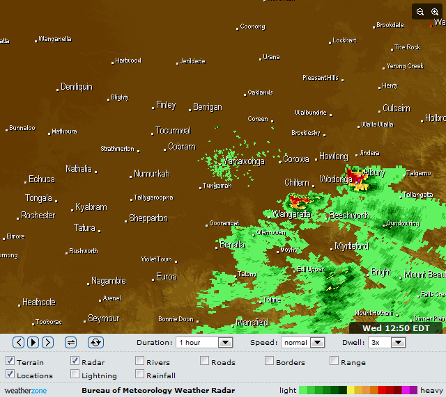
Oh how I miss my hometown Wodonga! Nice cellapocalypse » Wed Nov 09, 2011 10:13 am wrote:apocalypse wrote:Possible hook echo on the Albury storm, and previously on the storm to the SE of it.
Currently 26.1/19.2 with CAPE 1912 and LI -5.67 on analysis sounding.
"I'm in with the sane, does that make me Insane?"
"I lycra like that"
"I lycra like that"
- ShaneEEEE
- Cumulus
- Reactions:
- Posts: 50
- Joined: Sat Jan 02, 2010 2:30 pm
- Location: Lara, Victoria, Australia
Re: Victoria: Trough - showers/rain/storms - 6th-10th Novemb
I am not convinced that this cu field is going to do anything, I suspect the line on the border is going to get going shortly. I am just west of Ballarat atm but don't want to go too far west just in case the Cu field does go up. Nothing crisp within the Field as yet.
-
Supercellimpact

- Supercell
- Reactions:
- Posts: 1238
- Joined: Thu Oct 07, 2010 8:39 pm
- Location: Bendigo
Re: Victoria: Trough - showers/rain/storms - 6th-10th Novemb
Those storms are flying!
-
crikey

- Supercell
- Reactions:
- Posts: 1314
- Joined: Mon Feb 07, 2011 8:02 pm
- Location: tweed shire NSW and nDUNOLLY.. Nth Central district VIC
- Contact:
Re: Victoria: Trough - showers/rain/storms - 6th-10th Novemb
Yeah Supercellimpact. Wondering if the speed of those bands could limit larger totals of rain? However currently you could argue there are 3 lines of storms on the way to vic atm from SA and some activity in NSW could press further south over the border into northern vic near albury as well.
Hi Brayden. Nice of you. to drop over from WA .. Not sure we can match the storms you've been having lately but time will tell.
Great to have another new contributor. Welcome Ronnie.
Hi Brayden. Nice of you. to drop over from WA
Great to have another new contributor. Welcome Ronnie.
-
AUS_Twisted

- Storm Chaser
- Reactions:
- Posts: 652
- Joined: Wed Nov 25, 2009 6:15 pm
- Location: Dandenong North, Melb
Re: Victoria: Trough - showers/rain/storms - 6th-10th Novemb
The CU sure is flying along up there and rotating around a fair bit
-
crikey
- Supercell
- Reactions:
- Posts: 1314
- Joined: Mon Feb 07, 2011 8:02 pm
- Location: tweed shire NSW and nDUNOLLY.. Nth Central district VIC
- Contact:
Re: Victoria: Trough - showers/rain/storms - 6th-10th Novemb
TOP PRIORITY FOR IMMEDIATE BROADCAST
SEVERE THUNDERSTORM WARNING
for DAMAGING WIND, FLASH FLOODING and LARGE HAILSTONES
For people in parts of the
South West,
North East and
Wimmera Forecast Districts.
Issued at 12:35 pm Wednesday, 9 November 2011.
Severe thunderstorms are likely to produce damaging winds, very heavy rainfall, flash flooding and large hailstones in the warning area over the next several hours. Locations which may be affected include Hamilton, Warrnambool, Portland, Wodonga, Wangaratta and Falls Creek.
- sparra
- Cumulonimbus
- Reactions:
- Posts: 103
- Joined: Mon Aug 08, 2011 11:11 am
- Location: Netherby, via Nhill
Re: Victoria: Trough - showers/rain/storms - 6th-10th Novemb
Very dark out to our west and can hear the thunder now. It is very windy here and has been for the last while so thinking the storms will by flying?
Reports of crop damage in SA form storms last night so hoping we will miss out on that sort of action!!!
Reports of crop damage in SA form storms last night so hoping we will miss out on that sort of action!!!
- Rhino
- Supercell
- Reactions:
- Posts: 1227
- Joined: Mon Nov 30, 2009 11:37 am
- Location: Carisbrook-Near Maryborough
Re: Victoria: Trough - showers/rain/storms - 6th-10th Novemb
Bloody hell, SA is looking huge at the moment, all moving this way. 
Rhino.
Rhino.
- tonycynic
- Cumulonimbus
- Reactions:
- Posts: 494
- Joined: Tue Feb 15, 2011 5:57 pm
- Location: Mount Evelyn (h),Donvale (w)
Re: Victoria: Trough - showers/rain/storms - 6th-10th Novemb
The wind has picked up here and the clear blue slies of an hour ago are now 50% grey. Still 26c here with a 21c dp and 75% rh.
-
AUS_Twisted
- Storm Chaser
- Reactions:
- Posts: 652
- Joined: Wed Nov 25, 2009 6:15 pm
- Location: Dandenong North, Melb
Re: Victoria: Trough - showers/rain/storms - 6th-10th Novemb
Mostly everything local around here is getting ripped apart
-
Duckey

- Cumulonimbus
- Reactions:
- Posts: 283
- Joined: Sun Mar 07, 2010 3:39 pm
- Location: Live: Croydon Work: Burwood
Re: Victoria: Trough - showers/rain/storms - 6th-10th Novemb
Bright blue sky and sunshine here now for the past couple of hours. It's very uncomfortable and steamy out in the sun, however the wind is very strong and gusty. Clouds starting to build rapidly to my north east, which was the opposite direction than I was expecting. It's going to be interesting to see what develops over the next few hours. I think there's a few people out chasing today, best of luck, should be some very picturesque storm development!
Storm Nerd!!
- Pete
- Cumulonimbus
- Reactions:
- Posts: 470
- Joined: Mon May 30, 2011 9:02 pm
- Location: Albany, Western Australia
Re: Victoria: Trough - showers/rain/storms - 6th-10th Novemb
Hey guys, sorry to interrupt. Just a question I have on Melborune's sounding. Which one is the temperature line? I'm asking this because someone on facebook mentioned that the EL is around 200mb but it looks to me like there's no tropopause. Am I correct?

-
Supercellimpact
- Supercell
- Reactions:
- Posts: 1238
- Joined: Thu Oct 07, 2010 8:39 pm
- Location: Bendigo
Re: Victoria: Trough - showers/rain/storms - 6th-10th Novemb
Black cores now evident over SA
- sparra
- Cumulonimbus
- Reactions:
- Posts: 103
- Joined: Mon Aug 08, 2011 11:11 am
- Location: Netherby, via Nhill
Re: Victoria: Trough - showers/rain/storms - 6th-10th Novemb
Nearly on us now and the wind has dropped right off.....it is very noisy...our guinea fowl are going off their heads!!
-
mick

- Supercell
- Reactions:
- Posts: 1453
- Joined: Mon Nov 30, 2009 6:45 pm
- Location: Mid North SA Baaaaaaaaaaaaaaa
Re: Victoria: Trough - showers/rain/storms - 6th-10th Novemb
Wing has swung around to the west down here.
-
apocalypse

- Cumulonumbus Calvas
- Reactions:
- Posts: 761
- Joined: Tue Jan 19, 2010 6:17 pm
- Location: Wagga Wagga, NSW 189m asl
Re: Victoria: Trough - showers/rain/storms - 6th-10th Novemb
The temperature is the right red line. The tropopause is somewhere around the 200mb level where temperature increases with height, and this is also where the EL is (parcel temp equal to surrounding air temp at that height).
Nathan Morris
2013 Rainfall
Jan - 3.8mm
Feb - 27.0mm
Mar - 0.0mm
YTD - 30.8mm
2013 Rainfall
Jan - 3.8mm
Feb - 27.0mm
Mar - 0.0mm
YTD - 30.8mm
-
Karl Lijnders

- Tornadic Supercell
- Reactions:
- Posts: 5771
- Joined: Sun Nov 22, 2009 11:17 pm
- Location: Knoxfield, Victoria
Re: Victoria: Trough - showers/rain/storms - 6th-10th Novemb
Quite severe weather now developing. Storms are atleast 42000ft or more at this time. Lots of wind, hail and heavy rain to come over the coming few hours with activty peaking over C areas between 5-7pm. Should see some fairly intense weather building into Melbourne from the W and N over the coming 2hrs.
Really going to be a wild few hours and then some heavy thundery rain to follow mainly over C areas.
Really going to be a wild few hours and then some heavy thundery rain to follow mainly over C areas.
Former Owner - The Australian Weather Forum. Email me anytime - weatherman1000@hotmail.com
- HarleyB
- Cumulonumbus Calvas
- Reactions:
- Posts: 839
- Joined: Sun Oct 10, 2010 9:39 pm
- Location: Wangaratta
Re: Victoria: Trough - showers/rain/storms - 6th-10th Novemb
28/18 here. I do hope we get lots of rain here.