What about the warm anomaly off the south west coast of WA Johnno?
Is that warm anomaly likely to compensate our loss from el Nino pattern? deliver moisture for southern quadrant of OZ this spring summer?
at least s/west WA and SA?
It has started to rain in Perth this week?
From your post
A neg 3 deg cold anomaly around the top end NT ,coastline.! wow.
Wonder what that will do for the cyclone season.at the top end?
I assume those cold anomalies means less rainfall and storms for the top end?
Maybe the monsoon will be weak this season ?
Coral sea cooling.. Maybe generally weak monsoon and cyclone season?
or is there other considerations?
I found this link showing the strong correlation between SST global patterns and global rainfall patterns
Excellent correlation.. Where the oceans are warmer, there is more precipitation and vice versa
http://earthobservatory.nasa.gov/Featur ... .php?all=y" onclick="window.open(this.href);return false;

Welcome New Members! We want to hear from you. Register, stop lurking and start posting!
2012/2013 IOD
-
Anthony Violi

- Supercell
- Reactions:
- Posts: 2652
- Joined: Mon Nov 23, 2009 9:03 pm
- Location: Lilydale
- Contact:
Re: 2012/2013 IOD
Nothing is set in stone.. still at least 6 weeks away from seeing where we go from here.
This time last year all the models pencilled in an El nino and we had a secondary La Nina.
And what you need to do is look historically and see why things have occured and the drivers for it.
This time last year all the models pencilled in an El nino and we had a secondary La Nina.
And what you need to do is look historically and see why things have occured and the drivers for it.
http://www.therealworldweatherforum.com" onclick="window.open(this.href);return false;
avweatherforecasts.com
avweatherforecasts.com
-
Karl Lijnders

- Tornadic Supercell
- Reactions:
- Posts: 5771
- Joined: Sun Nov 22, 2009 11:17 pm
- Location: Knoxfield, Victoria
Re: 2012/2013 IOD
Looking like the shift away from El Nino is stepping up a notch with CFSv2 indicating that members are pointing to a strong La Nina developing. This does not necessarily mean it will come in the next few months, but there is a growing trend towards a La Nina in the next 6 months and developing through our summer.
Certainly an interesting time for the Eastern areas of Australia.
Over the next few weeks we should start to see the impacts of inland troughs and possibly an early start to the WA heat trough which could spawn low pressure cells for us into September.
Certainly an interesting time for the Eastern areas of Australia.
Over the next few weeks we should start to see the impacts of inland troughs and possibly an early start to the WA heat trough which could spawn low pressure cells for us into September.
Former Owner - The Australian Weather Forum. Email me anytime - weatherman1000@hotmail.com
-
crikey

- Supercell
- Reactions:
- Posts: 1314
- Joined: Mon Feb 07, 2011 8:02 pm
- Location: tweed shire NSW and nDUNOLLY.. Nth Central district VIC
- Contact:
Re: 2012/2013 IOD
The current 3 monthly rainfall anomalies showing a rainfall pattern associated with El Nino currently..
The low rainfall anomalies seem to associated with the west of OZ and not the eastern seaboard
and the Indian ocean has been warm in the s/west ?
and record dry in s/west WA.
maybe SAM's been too positive? Also lacking N/west cloud moisture in-feeds?

The low rainfall anomalies seem to associated with the west of OZ and not the eastern seaboard
and the Indian ocean has been warm in the s/west ?
and record dry in s/west WA.
maybe SAM's been too positive? Also lacking N/west cloud moisture in-feeds?
-
Anthony Violi
- Supercell
- Reactions:
- Posts: 2652
- Joined: Mon Nov 23, 2009 9:03 pm
- Location: Lilydale
- Contact:
Re: 2012/2013 IOD
YEs Crikey that has nothing to do with El Nino conditions.
Its more to do with the seasonal shift and colder water over the top end. Strong Easterlies have dried out the interior.
We have had a zonal shift this year whereby the highs and lows are in different positions relevant to last year.
This year, highs are sitting themselves over the WA region, and the lows have been barrelling over our region.
In any case, not really important as the next 6 months are when we see the effects of an El nino or La nina.
The El nino has already peaked, despite CFS insisting a massive explosion of warmth across the basin.
See here.

Compared to current conditions it would need to totally reverse the trend.

This is yesterday, and compare that with 3 weeks ago. Notice its pushing the heat Eastwards, meaning there are no westerlies present at the surface and thats why the cold upwelling is occuring on the SA coast.
3 weeks ago.

Also notice how much stronger the cold is north of the equator, consistent with a cold PDO. And this is cooling the central pacific and CFS hasnt picked it up, despite me mentioning it over a month ago.
The other indicator is upper heat content, which has also peaked, and this leads Nino 3.4 by about a month. So this months value is the top of the range, which is 0.8 and barely nino threshold. And needs to be consistently 0.8 for 3 months by definition.

Onto the IOD, it will warm rapidly within a month, all the cold is at the surface, the subsurface is warm. Once the seasonal winds disappear it will be business as usual and i expect as lot of rain throughout the country this Spring.
Will be a good test case for our forecasts, which indicate good probailiteis for higher rainfall and humidity again.
Its more to do with the seasonal shift and colder water over the top end. Strong Easterlies have dried out the interior.
We have had a zonal shift this year whereby the highs and lows are in different positions relevant to last year.
This year, highs are sitting themselves over the WA region, and the lows have been barrelling over our region.
In any case, not really important as the next 6 months are when we see the effects of an El nino or La nina.
The El nino has already peaked, despite CFS insisting a massive explosion of warmth across the basin.
See here.
Compared to current conditions it would need to totally reverse the trend.
This is yesterday, and compare that with 3 weeks ago. Notice its pushing the heat Eastwards, meaning there are no westerlies present at the surface and thats why the cold upwelling is occuring on the SA coast.
3 weeks ago.
Also notice how much stronger the cold is north of the equator, consistent with a cold PDO. And this is cooling the central pacific and CFS hasnt picked it up, despite me mentioning it over a month ago.
The other indicator is upper heat content, which has also peaked, and this leads Nino 3.4 by about a month. So this months value is the top of the range, which is 0.8 and barely nino threshold. And needs to be consistently 0.8 for 3 months by definition.
Onto the IOD, it will warm rapidly within a month, all the cold is at the surface, the subsurface is warm. Once the seasonal winds disappear it will be business as usual and i expect as lot of rain throughout the country this Spring.
Will be a good test case for our forecasts, which indicate good probailiteis for higher rainfall and humidity again.
http://www.therealworldweatherforum.com" onclick="window.open(this.href);return false;
avweatherforecasts.com
avweatherforecasts.com
-
crikey
- Supercell
- Reactions:
- Posts: 1314
- Joined: Mon Feb 07, 2011 8:02 pm
- Location: tweed shire NSW and nDUNOLLY.. Nth Central district VIC
- Contact:
Re: 2012/2013 IOD
Those highs you mention AV have directed cold air up across darwin to give them a record cold for the start of August, l believe.
and
S.west WA has had all time record drought recorded recently.
We have had an anomlously high pressure in the high pressure belt as well. which has been quite wide generally. Lack of strong vigorous cold fronts generally this autumn /winter. and lack of n/west cloud moisture infeeds
That cold air has been travelling across the top end with strong easterlies.and
According to this info on the IOD
Strong anomalous equatorial easterlies can cause cold upwelling up around north west of the top end and caused a positive IOD in 1997. Also an El Nino period
This is linked to a weakened Indian monsoon which according to the news is underway
http://en.wikipedia.org/wiki/Indian_Ocean_Dipole" onclick="window.open(this.href);return false;
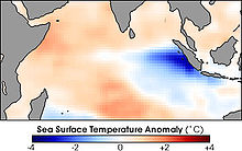
Water temperatures around the Mentawai Islands dropped about 4° Celsius during the height of the Indian Ocean Dipole in November of 1997. During these events unusually strong winds from the east push warm surface water towards Africa, allowing cold water to upwell along the Sumatran coast. In this image blue areas are colder than normal, while red areas are warmer than normal.
The IOD also affects the strength of monsoons over the Indian subcontinent. A significant positive IOD occurred in 1997–8, with another in 2006.

This pattern of cold easterlies have been travelling through that region near maldives for 6 weeks or more now?
quote
A positive phase sees greater-than-average sea-surface temperatures and greater precipitation in the western Indian Ocean region, with a corresponding cooling of waters in the eastern Indian Ocean—which tends to cause droughts in adjacent land areas of Indonesia and Australia.
maybe thats why WA is so dry and record dry in the s/west WA atm
and
S.west WA has had all time record drought recorded recently.
We have had an anomlously high pressure in the high pressure belt as well. which has been quite wide generally. Lack of strong vigorous cold fronts generally this autumn /winter. and lack of n/west cloud moisture infeeds
That cold air has been travelling across the top end with strong easterlies.and
According to this info on the IOD
Strong anomalous equatorial easterlies can cause cold upwelling up around north west of the top end and caused a positive IOD in 1997. Also an El Nino period
This is linked to a weakened Indian monsoon which according to the news is underway
http://en.wikipedia.org/wiki/Indian_Ocean_Dipole" onclick="window.open(this.href);return false;
Water temperatures around the Mentawai Islands dropped about 4° Celsius during the height of the Indian Ocean Dipole in November of 1997. During these events unusually strong winds from the east push warm surface water towards Africa, allowing cold water to upwell along the Sumatran coast. In this image blue areas are colder than normal, while red areas are warmer than normal.
The IOD also affects the strength of monsoons over the Indian subcontinent. A significant positive IOD occurred in 1997–8, with another in 2006.
This pattern of cold easterlies have been travelling through that region near maldives for 6 weeks or more now?
quote
A positive phase sees greater-than-average sea-surface temperatures and greater precipitation in the western Indian Ocean region, with a corresponding cooling of waters in the eastern Indian Ocean—which tends to cause droughts in adjacent land areas of Indonesia and Australia.
maybe thats why WA is so dry and record dry in the s/west WA atm
-
stratospear

- Supercell
- Reactions:
- Posts: 1261
- Joined: Sat Dec 19, 2009 9:38 am
- Location: Usually Bendigo
Re: 2012/2013 IOD
It does look like a +ve Indian Ocean Dipole is forming, albeit a not particularly strong one. The 2006-7 positive IOD was disastrous for Victoria - barely any rain at all in Winter and Spring, even with a weak LaNina in 2007! Some consolation occurred in December 2007 when monster storms came on the scene.
Luckily for VIC this year, the warmer than normal Southern Ocean has perhaps kept dew points up along our coastal regions and delivered good rains when fronts have come across. Although Inland Vic hasn't really benefited as much due to the lack of NW rainbands and the Great Dividing Range.
Luckily for VIC this year, the warmer than normal Southern Ocean has perhaps kept dew points up along our coastal regions and delivered good rains when fronts have come across. Although Inland Vic hasn't really benefited as much due to the lack of NW rainbands and the Great Dividing Range.
-
Anthony Violi
- Supercell
- Reactions:
- Posts: 2652
- Joined: Mon Nov 23, 2009 9:03 pm
- Location: Lilydale
- Contact:
Re: 2012/2013 IOD
The surface is cool which is seasonal. it will warm rapidly soon, probably by end of September.
And as per our forecast, we are going to see what she really can do.
And as per our forecast, we are going to see what she really can do.
http://www.therealworldweatherforum.com" onclick="window.open(this.href);return false;
avweatherforecasts.com
avweatherforecasts.com
Re: 2012/2013 IOD
AV,
You are tipping a big storm season for Melbourne/Victoria then?
What are your thoughts on when they may hit?
Or are you prediciting a big one?
Cheers.
You are tipping a big storm season for Melbourne/Victoria then?
What are your thoughts on when they may hit?
Or are you prediciting a big one?
Cheers.
-
Anthony Violi
- Supercell
- Reactions:
- Posts: 2652
- Joined: Mon Nov 23, 2009 9:03 pm
- Location: Lilydale
- Contact:
Re: 2012/2013 IOD
Yes another good storm season, though might be too humid yet again for any really big storms with clear air in keeping with past springs and summers.
Forecast is for repeat of the past 2 summers with very high rainfall and humidity. The scale is the only thing in question, do we break more records or do we see a summer like the last one. One thing that isn't it question is the flooding we will see, water table is saturated and rivers and dams are rapidly rising. Only a matter of time before it becomes a big problem.
Forecast is for repeat of the past 2 summers with very high rainfall and humidity. The scale is the only thing in question, do we break more records or do we see a summer like the last one. One thing that isn't it question is the flooding we will see, water table is saturated and rivers and dams are rapidly rising. Only a matter of time before it becomes a big problem.
http://www.therealworldweatherforum.com" onclick="window.open(this.href);return false;
avweatherforecasts.com
avweatherforecasts.com