TROPICAL CYCLONE TECHNICAL BULLETIN: AUSTRALIA - EASTERN REGION
Issued by BRISBANE TROPICAL CYCLONE WARNING CENTRE
at: 0629 UTC 21/01/2013
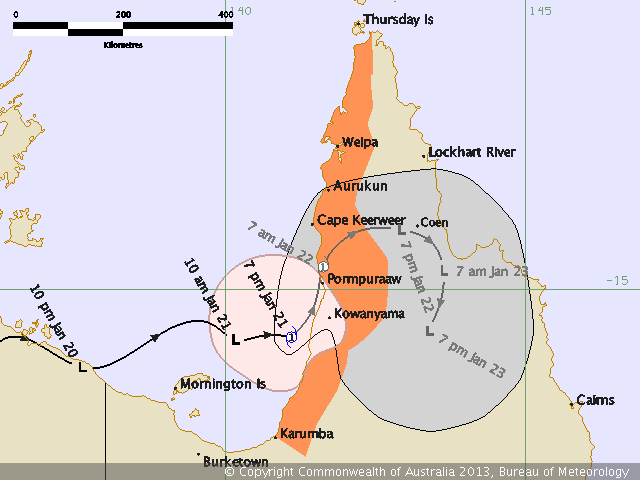
Name: Tropical Cyclone Oswald
Identifier: 07U
Data At: 0600 UTC
Latitude: 15.6S
Longitude: 141.1E
Location Accuracy: within 15 nm [30 km]
Movement Towards: east northeast [075 deg]
Speed of Movement: 9 knots [17 km/h]
Maximum 10-Minute Wind: 35 knots [65 km/h]
Maximum 3-Second Wind Gust: 50 knots [95 km/h]
Central Pressure: 992 hPa
Radius of 34-knot winds NE quadrant: 60 nm [110 km]
Radius of 34-knot winds SE quadrant: 30 nm [55 km]
Radius of 34-knot winds SW quadrant: 60 nm [110 km]
Radius of 34-knot winds NW quadrant: 90 nm [165 km]
Radius of 48-knot winds NE quadrant:
Radius of 48-knot winds SE quadrant:
Radius of 48-knot winds SW quadrant:
Radius of 48-knot winds NW quadrant:
Radius of 64-knot winds:
Radius of Maximum Winds: 20 nm [35 km]
Dvorak Intensity Code: T3.0/3.0/D1.5/24HRS
Pressure of outermost isobar: 998 hPa
Radius of outermost closed isobar: 80 nm [150 km]
Storm Depth: Deep
FORECAST DATA
Date/Time : Location : Loc. Accuracy: Max Wind : Central Pressure
[UTC] : degrees : nm [km]: knots[km/h]: hPa
+12: 21/1800: 14.5S 142.1E: 040 [070]: 030 [055]: 993
+24: 22/0600: 13.9S 143.1E: 065 [120]: 020 [035]: 998
+36: 22/1800: 14.5S 144.1E: 085 [155]: 020 [035]: 997
+48: 23/0600: 15.5S 144.1E: 105 [190]: 020 [035]: 997
+60: 23/1800: 16.6S 143.6E: 120 [225]: 020 [035]: 997
+72: 24/0600: 17.4S 143.1E: 140 [265]: 020 [035]: 997
REMARKS:
Dvorak analysis based on a curved band pattern with 0.7 degree wrap on a log 10
spiral. DT is 3.0. MET not used as the system was over land 24 hours ago. FT
based on DT.
Northeast movement is expected to continue until landfall. Some numerical
guidance indicates more NNE'ly movement after 6 hours, but will assume this
occurs after landfall at this stage.
Copyright Commonwealth of Australia
==
The next bulletin for this system will be issued by: 21/1300 UTC by Brisbane
TCWC.
I will leave out my opinions on cyclone naming....