
Welcome New Members! We want to hear from you. Register, stop lurking and start posting!
Climate Driver Discussion 2019 (Enso, IOD, PDO , SAM)
- weathergasm
- Cumulonimbus
- Reactions:
- Posts: 244
- Joined: Sun Feb 14, 2010 9:32 pm
- Location: Box Hill
Re: Climate Driver Discussion 2019 (Enso, IOD, PDO , SAM)
All those upper troughs won’t do us much good if they’re not meeting up with some tropical moisture, so here’s hoping the +IOD breaks down sooner rather than later.
- StratoBendigo
- Supercell
- Reactions:
- Posts: 2817
- Joined: Fri Jan 02, 2015 2:18 pm
- Location: Kangaroo Flat
Re: Climate Driver Discussion 2019 (Enso, IOD, PDO , SAM)
Indian Ocean Dipole is around +2c atm. Probably won't go neutral until after January.weathergasm wrote: ↑Wed Nov 06, 2019 11:50 am All those upper troughs won’t do us much good if they’re not meeting up with some tropical moisture, so here’s hoping the +IOD breaks down sooner rather than later.
The Central Indian Ocean is rather hot at present, which might convey some moisture into Southern Australia.
- JasmineStorm
- Supercell
- Reactions:
- Posts: 1870
- Joined: Thu Sep 22, 2016 9:40 pm
- Location: Kyneton 527 ASL
Re: Climate Driver Discussion 2019 (Enso, IOD, PDO , SAM)
It already has met moisture. That's what triggered the inland rain and storms over NSW, QLD and Vic so far in Nov.weathergasm wrote: ↑Wed Nov 06, 2019 11:50 am All those upper troughs won’t do us much good if they’re not meeting up with some tropical moisture, so here’s hoping the +IOD breaks down sooner rather than later.
- Attachments
-
- Upper trough.jpg (335.83 KiB) Viewed 18133 times
- StratoBendigo
- Supercell
- Reactions:
- Posts: 2817
- Joined: Fri Jan 02, 2015 2:18 pm
- Location: Kangaroo Flat
Re: Climate Driver Discussion 2019 (Enso, IOD, PDO , SAM)
These strong Westerlies have dumped huge quantities of dust from the Simpson Desert and inland Australia into the Tasman Sea off NSW this morning.
Satpic is bonkers!
Satpic is bonkers!
-
Didjman

- Supercell
- Reactions:
- Posts: 2100
- Joined: Fri Sep 03, 2010 2:52 pm
- Location: Wallan, Vic 328m ASL
- Contact:
Re: Climate Driver Discussion 2019 (Enso, IOD, PDO , SAM)
The dust can still be seen out there in the Tasman!
- StratoBendigo
- Supercell
- Reactions:
- Posts: 2817
- Joined: Fri Jan 02, 2015 2:18 pm
- Location: Kangaroo Flat
Re: Climate Driver Discussion 2019 (Enso, IOD, PDO , SAM)
Much of Vic has done well for rain in past week because of:
1) Strongly -ve AAO
2) MJO in Phase 5
3) LWT in the right spot.
Triple whammy.
1) Strongly -ve AAO
2) MJO in Phase 5
3) LWT in the right spot.
Triple whammy.
-
Didjman
- Supercell
- Reactions:
- Posts: 2100
- Joined: Fri Sep 03, 2010 2:52 pm
- Location: Wallan, Vic 328m ASL
- Contact:
Re: Climate Driver Discussion 2019 (Enso, IOD, PDO , SAM)
We can thank the SSW event back in August / September for pushing back the fire season in parts of SA and all of Vic / Tas. The same event that is scorching NSW though 
- weathergasm
- Cumulonimbus
- Reactions:
- Posts: 244
- Joined: Sun Feb 14, 2010 9:32 pm
- Location: Box Hill
Re: Climate Driver Discussion 2019 (Enso, IOD, PDO , SAM)
I think the front tomorrow is going to be very typical of the kind of moisture-sapped, gusty cold front we’ll see a lot of this summer here in Melbourne. Until at least January it seems - the BOM have said in their latest tropical update there is no sign of any monsoon trough south of the equator, and therefore very little tropical moisture of the kind we need for good rains unless we get lucky (as we did earlier this month).
Kind of depressing!
Kind of depressing!
- StratoBendigo
- Supercell
- Reactions:
- Posts: 2817
- Joined: Fri Jan 02, 2015 2:18 pm
- Location: Kangaroo Flat
Re: Climate Driver Discussion 2019 (Enso, IOD, PDO , SAM)
BOM Outlook for summer is out. Going for a damp WA, and dry Eastern Seaboard. Hot everywhere.
Re: Climate Driver Discussion 2019 (Enso, IOD, PDO , SAM)
Hello Weatherybods,
Thought I'd try out my weather eyes, and see if anyone here has a finger on the pulse of how southern South America is experiencing this extended negative SAM? I would guess that the pattern of Lows would be staying more northerly than would be usual, and possibly bringing more precipitation with it, but not having a feel for the "usual" for that region I thought I'd check in here
Would also add I've really enjoyed finding this forum, and floating around to see what meteorological gems I can glean!
Thanks
J
- Sean
- Supercell
- Reactions:
- Posts: 1000
- Joined: Mon Feb 27, 2012 6:35 pm
- Location: Patterson Lakes - SE Melb
Re: Climate Driver Discussion 2019 (Enso, IOD, PDO , SAM)
This prospect sure came to fruition. What a shocking start to the fire season.Didjman wrote: ↑Tue Oct 01, 2019 6:11 pmCouple that with SAM going -ve, and we have bad fire weather!weathergasm wrote: ↑Tue Oct 01, 2019 5:44 pm Latest ENSO wrap-up from BOM released today indicates positive IOD going from strength to strength:
“The Indian Ocean Dipole (IOD) remains positive, with the latest weekly index value to 29 September at +1.76 °C. This is the highest weekly value observed in the Bureau's dataset which extends from 2001 to present. Last week's value of +1.50 °C is the second highest on record.”
http://www.bom.gov.au/climate/enso/#tabs=Indian-Ocean
Not good news for those of us in the southeast in the next few months, at least. I’m very pessimistic about the chances of good rains before Christmas.
- StratoBendigo
- Supercell
- Reactions:
- Posts: 2817
- Joined: Fri Jan 02, 2015 2:18 pm
- Location: Kangaroo Flat
Re: Climate Driver Discussion 2019 (Enso, IOD, PDO , SAM)
It's nice to see the +ve IOD finally dissipating. Water is boiling between Darwin and Timor at present, so something's got to give soon....
- Sean
- Supercell
- Reactions:
- Posts: 1000
- Joined: Mon Feb 27, 2012 6:35 pm
- Location: Patterson Lakes - SE Melb
Re: Climate Driver Discussion 2019 (Enso, IOD, PDO , SAM)
What's the bet it's going to be dramatic given that it's a never ending run of extremes these days?StratoBendigo wrote: ↑Thu Dec 12, 2019 4:09 pm It's nice to see the +ve IOD finally dissipating. Water is boiling between Darwin and Timor at present, so something's got to give soon....
It feels like good rains are a thing of the past, yet it also seems like a switch will flick and the continent will be inundated at some point given how strong these climate drivers have been.

Re: Climate Driver Discussion 2019 (Enso, IOD, PDO , SAM)
This might be of interest.
https://judithcurry.com/2019/09/01/enso ... -activity/
From what I can determine solar appears to drive alterations in the brewer Dobson circulation that weaken trade winds/polar vortex during the descending phase of the cycle (like stratospheric autumn) while doing the opposite during the ascending phase. That probably means we won’t see La Niña till 2021 with the deep solar minimum we are having.
Also a good paper on the post hiatus warming indicating it was driven by cloud changes related to PDO.
https://res.mdpi.com/d_attachment/clima ... -00062.pdf
- StratoBendigo
- Supercell
- Reactions:
- Posts: 2817
- Joined: Fri Jan 02, 2015 2:18 pm
- Location: Kangaroo Flat
Re: Climate Driver Discussion 2019 (Enso, IOD, PDO , SAM)
The extremely hot water temps of the NW coast of Australia is raising eyebrows (warmest since Feb 2011).
https://www.abc.net.au/news/2019-12-18/ ... e/11808268
Perhaps a spectacular tropical downpour on the cards in the coming weeks/months? Something's gotta give....
https://www.abc.net.au/news/2019-12-18/ ... e/11808268
Perhaps a spectacular tropical downpour on the cards in the coming weeks/months? Something's gotta give....
- Sean
- Supercell
- Reactions:
- Posts: 1000
- Joined: Mon Feb 27, 2012 6:35 pm
- Location: Patterson Lakes - SE Melb
Re: Climate Driver Discussion 2019 (Enso, IOD, PDO , SAM)
Came here to note the same thing. If the winds reverse, those rains flooding eastern Africa may start dumping on Australia. It's not a given, but the potential is there.StratoBendigo wrote: ↑Wed Dec 18, 2019 2:01 pm The extremely hot water temps of the NW coast of Australia is raising eyebrows (warmest since Feb 2011).
https://www.abc.net.au/news/2019-12-18/ ... e/11808268
Perhaps a spectacular tropical downpour on the cards in the coming weeks/months? Something's gotta give....
We just have to wait and see whether the temperature differential is enough to see the winds change direction (pray for a sudden cooling event in the eastern Indian ocean lol!)
- StratoBendigo
- Supercell
- Reactions:
- Posts: 2817
- Joined: Fri Jan 02, 2015 2:18 pm
- Location: Kangaroo Flat
Re: Climate Driver Discussion 2019 (Enso, IOD, PDO , SAM)
MJO pulse is still several weeks away from being in the right zone. It was good last week but ITCZ was still way North (Equatorial).
Maybe something mid-late January. Horrifically hot in the meantime.
Maybe something mid-late January. Horrifically hot in the meantime.
-
Didjman
- Supercell
- Reactions:
- Posts: 2100
- Joined: Fri Sep 03, 2010 2:52 pm
- Location: Wallan, Vic 328m ASL
- Contact:
Re: Climate Driver Discussion 2019 (Enso, IOD, PDO , SAM)
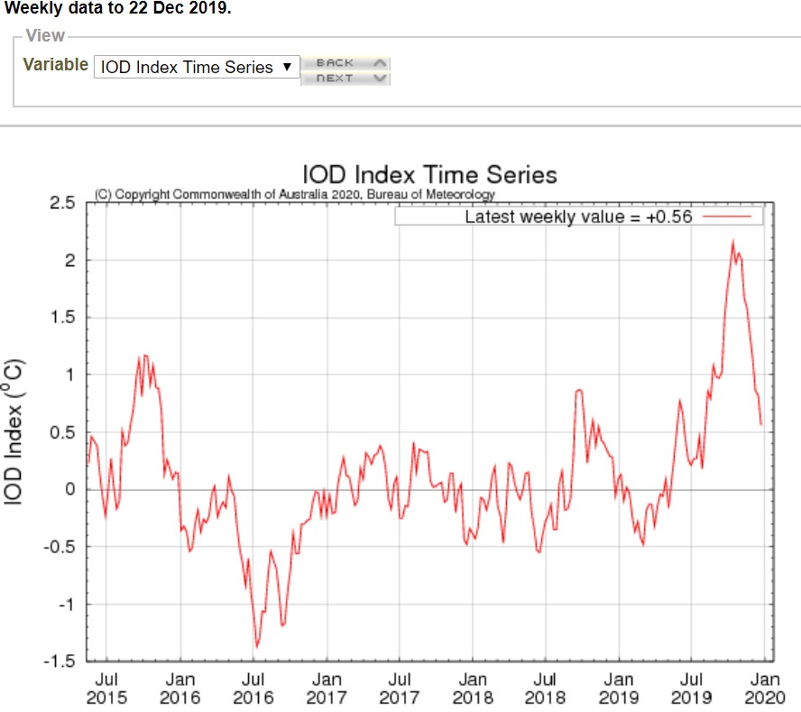
IOD is coming down (SSTs are almost the same across the IO), but SAM is still negative.
-
Didjman
- Supercell
- Reactions:
- Posts: 2100
- Joined: Fri Sep 03, 2010 2:52 pm
- Location: Wallan, Vic 328m ASL
- Contact:
Re: Climate Driver Discussion 2019 (Enso, IOD, PDO , SAM)
Current IOD:
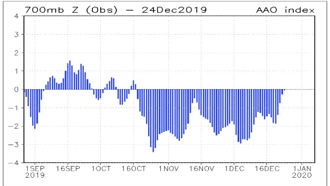
Current SAM:
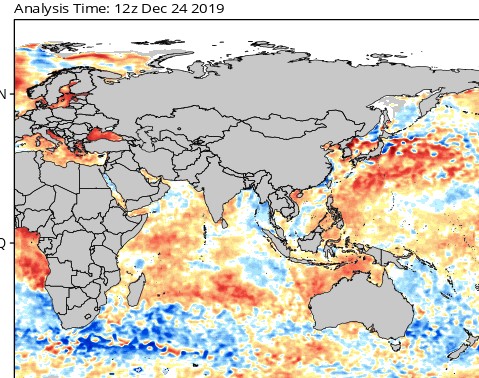
Current IO SST anomalies:
We just need the monsoon to fire up and our storm season might belatedly commence
Current SAM:
Current IO SST anomalies:
We just need the monsoon to fire up and our storm season might belatedly commence
- JasmineStorm
- Supercell
- Reactions:
- Posts: 1870
- Joined: Thu Sep 22, 2016 9:40 pm
- Location: Kyneton 527 ASL
Re: Climate Driver Discussion 2019 (Enso, IOD, PDO , SAM)
The floods are coming.
- Attachments
-
- ECMF GEFS MJO.jpg (188.46 KiB) Viewed 16931 times