Event discussion and analysis for Victoria and Tasmania, including day to day weather.
Forum rules
When posting photos, particularly in active breaking weather threads, please link to clickable photos to minimise download issues. For more information, see Posting Photo Guidelines for more information. Threads that are six weeks old or older will be Archived Here
Slow moving broad trough in the easterlies looks like breaking up the dry pattern. System has two parts - a dip coming down the middle of NSW likely to reach about Melbourne’s northern burbs. Looks quite wet for the northern country and north central. Melbourne is on the boundary, but looks like the northern burbs will get something, perhaps the southern will miss out.
Second parts is broad northeast to easterly warm air advection from the Tasman which will come onto the eastern third of TAS and Gippsland. Thats tapping really high moisture total and being slow will drop heavy heavy but quite local falls. Already seen local falls over 25mm from that in Tas which is really welcome.
System all clears out around Tuesday with a front in the westerlies which looks good for TAS, but most slips under VIC. Maybe another big high after that
Had our first short but quite heavy shower earlier. Bizarre experiencing almost stormy weather with the barometer at 1032 hPa (I'm weather-confused a lot these days.)
Gordon wrote: ↑Thu May 09, 2024 9:06 am
Had our first short but quite heavy shower earlier. Bizarre experiencing almost stormy weather with the barometer at 1032 hPa (I'm weather-confused a lot these days.)
We’ve now had about 15mm with a barometer above 1035hPa. Been foggy to sea level for 48 hours and barely stopped dripping on us. Currently thick drizzle with embed showers.
Up the road on Kunanyi has been about 50mm, the best fall for months.
Never seen weather like this.
Looks quite wet here tonight and for northern Vic. South of the divide bit line ball. After this lot…. Well another thumping high
Well and truly a wet night here in the southern parts that were borderline
Gordon wrote: ↑Thu May 09, 2024 9:06 am
Had our first short but quite heavy shower earlier. Bizarre experiencing almost stormy weather with the barometer at 1032 hPa (I'm weather-confused a lot these days.)
I’m sure your not the only one….
Melb Wednesday Thursday thick very unclear skies,
Weather coming in from a different direction..
11mm overnight.
Rainy night for eastern TAS. Wettest day in Hobart for a month, with some higher falls in the hill suburbs… locally topping 25mm. Still raining lighty. Few spots have seen their wettest spell in over a year. Definitely short of a drought breaker but really welcome.
Surprised to see central Victoria do so well. Not a great pick by the progs which kept it mostly north of the cbd in the lead up. Doubt many complaints, particularly amongst farmers.
Damp humid day for the middle of Victoria and eastern TAS. Some local heavier falls, though patchy and slow moving. Troughs then weakens for Saturday and Sunday but just the odd shower remaining. Unfortunately the trough moving up on Perth erodes the one over VIC. Shame about the timing as this could have all developed into a classical trough to low to could outbreak scenario but won’t be.
Strange weather for almost winter, but happy to get regardless of how it falls. So mild and humid.
Btw Nino 3.4 just tipped into negative. That’s really early and you need to take bout 0.5 off it because of global warming to make it comparable to previous La Nina events. Suggest a solid event is likely. Obs backing off on the positive IOD so hopefully get a La Niña only (though think those in NSW and QLD will be hoping not). Maybe this event is the first hint at what’s to come.
Finally some weather to post about. Constant rain on the old tin roof started about midnight and continues in heavy to moderate spurts. 22mm here so far and very welcome.
20mm here, quite heavy at times late in the evening. Currently a beautiful autumn morning, cool, misty and barely a breath of wind. Should rain again later though.
Blackee wrote: ↑Fri May 10, 2024 8:16 am
Finally some weather to post about. Constant Tain on the old tin roof started about midnight and continues in heavy to moderate spurts. 22mm here so far and very welcome.
Almost 20 mm in the gauge overnight here in Truganina.
I would say our climate here in Melbourne has certainly become a very mild one in recent history. Winter is knocking on our door, very doesn't feel like it.
Misty drizzly 24 hours around Hobart. Another 2mm here, but 12mm on the top of the mountain. Closes out this part of the event, though a strong front here through on Monday, but most rain will sit over northern and western TAS.
Awesome to see good falls through the centre of VIC and eastern Tasmania, and TAS north and west will catch up on Monday. Unfortunately western VIC and SA have missed out and are on track for a record dry May unless the last week delivers something.
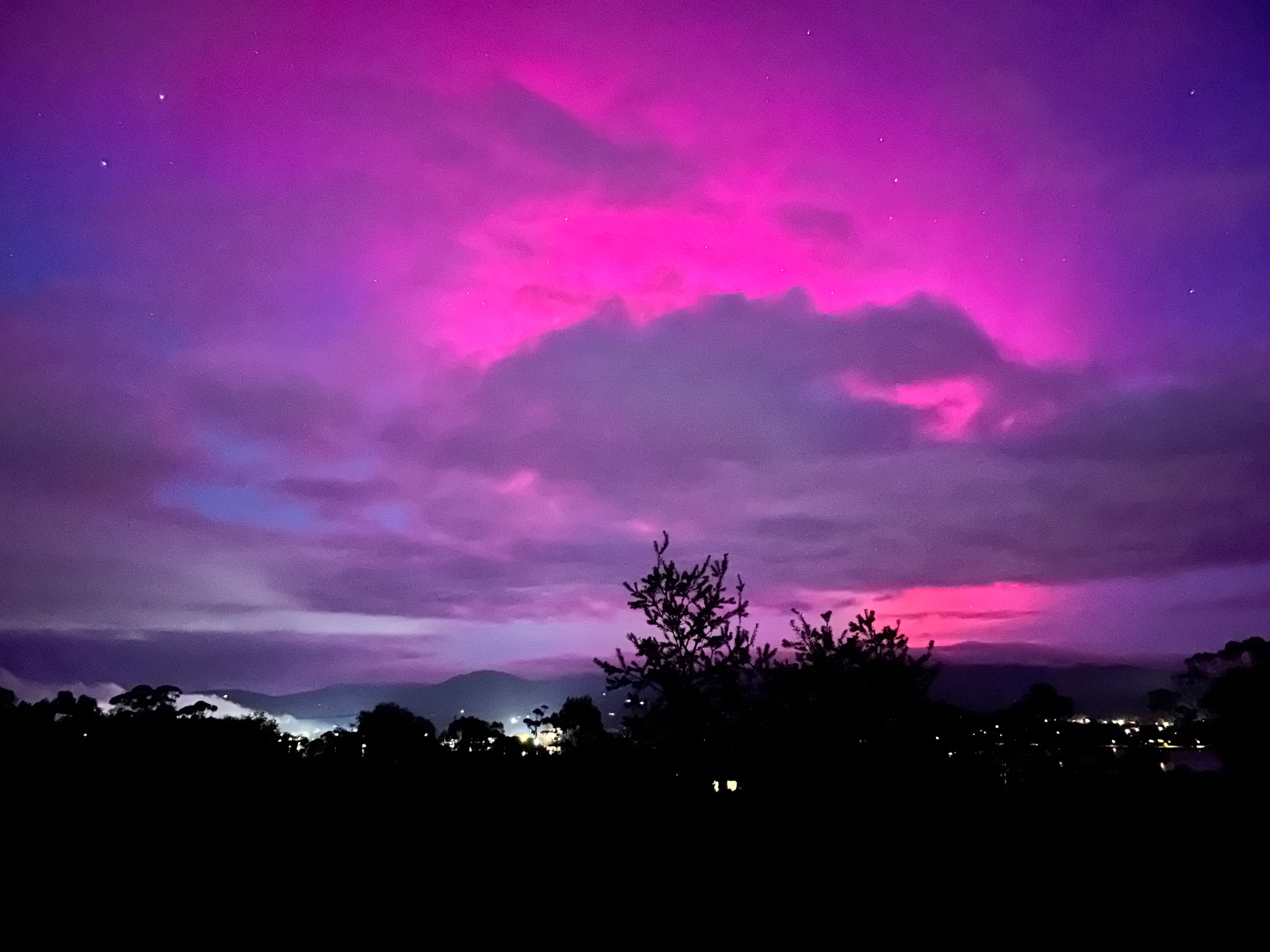
Thankfully cloud cleared here just before sunrise and we got this. Sky was lit up like a sunset but purple the main colour. Best here in years.
A touch under 14mm here since Thursday night. Quite solid overnight Thursday into Friday morning despite the forecast. Nice surprise to break up the dry spell.
Hoping the skies clear up tonight to see some Aurora action.