Page 1 of 3
SE AUS: Increasing storm potential 8/1 to 16/1
Posted: Wed Jan 05, 2011 9:58 am
by Blackee
As mentioned in the Breaking Weather board, things falling into place for a storm outbreak as early as Saturday (albeit isolated), but definitely Sunday onwards.
GFS (Stormcast) is fairly keen for activity to linger until mid week, but it subject to wild variation.
Perhaps the return of some late afternoon and evening chases!!

Re: SE AUS: Increasing storm potential 8/1 to 16/1
Posted: Wed Jan 05, 2011 12:33 pm
by Meso
So typical...no storms the entire two weeks I'm on holiday then as soon as it's time to go back to work.

GFS looks good Sunday through Wednesday tho, but not getting too excited just yet. This long period of dry weather lately has made me pretty skeptical.
Re: SE AUS: Increasing storm potential 8/1 to 16/1
Posted: Wed Jan 05, 2011 1:14 pm
by Jake Smethurst
The thunderstorm potential begins today in-fact over the far eastern ranges. It is only rather a minimal risk, nevertheless, it is there, and some lift on the ranges with some marginal instability could get some cells going this afternoon.
Bit of a breather for tomorrow with high pressure generally dominating the state.
The high will generally keep Victoria hot on Friday with a northwesterly airstream, however a trough over South Australia will extend eastwards towards western Victoria during the day and isolated afternoon showers and thunderstorms are possible over these districts.
The change will move across Victoria gradually on Saturday with the thunderstorm risk.
From Sunday until the eye can see, it looks quite thundery on each day with most of the state a risk on each day. Will know more when this gets closer.
Re: SE AUS: Increasing storm potential 8/1 to 16/1
Posted: Wed Jan 05, 2011 6:53 pm
by Petros
Jeez Sniper - thats a gutsy thread outlook - 8 days long and still 3 days out before it all starts! - good on you.

Agree, this approaching prolonged weather event is now looking dynamic and seems to be the Easterly Dip scenario I (erronously as usual) thought may be in play over Vic right now.
BOM's ACCESSG is the main model to support your theory.
Re: SE AUS: Increasing storm potential 8/1 to 16/1
Posted: Wed Jan 05, 2011 7:37 pm
by Blackee
Hee Hee Petros. There is enough there to raise my eyebrows this far out!
Probably crash and burn, but am really hoping for our first outbreak for 2011..
Re: SE AUS: Increasing storm potential 8/1 to 16/1
Posted: Thu Jan 06, 2011 10:44 am
by Hamlan
It appears there will be storms about for sure but for me the depressing thing is the very poor shear profile that dominates the outlook. We have been blessed with fantastic speed and directional shear with height this season but it's missing from the equation now and I would be assuming there will be a heavy reliance on local shear enhancement and boundaries for any really organised storms.......unless things change

Re: SE AUS: Increasing storm potential 8/1 to 16/1
Posted: Thu Jan 06, 2011 10:36 pm
by Blackee
No, not the best set-up Brad and still very messy in regards to progs next week.
Quite wild fluctuations in location and severity (all bar Wednesday).
GFS pointed more to the western parts of VIC and well into SA (which supports the high accumulated precip values prog'd also).
Will be up at Lake Eildon on Saturday and Sunday so may get a nice view of a view developing over Mt Buller and sliding south..
Re: SE AUS: Increasing storm potential 8/1 to 16/1
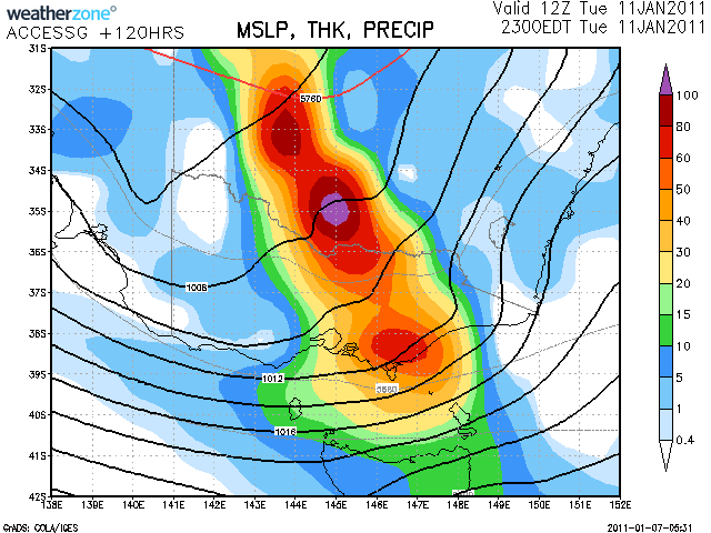
Posted: Fri Jan 07, 2011 12:28 pm
by Petros
Can I have this scenario as the outcome please.
Re: SE AUS: Increasing storm potential 8/1 to 16/1
Posted: Fri Jan 07, 2011 1:35 pm
by flatcam
That would be a great outcome!! Eildon would get a lot of it too judging by the chart.
Can't wait for the storms to start! Haven't seen one for a while and would like to try and photograph them a bit more (Pano's etc.).
Also, is that chart just for Tuesday next week? Or a longer period? A bit new to looking at the technical side of storms and haven't seen many of these charts before, so I'm not sure.
Also new to the forums, so hopefully I can contribute and help others. My knowledge of storms is a bit limited but I will try to help as much as I can.
Looking forward to it!
Cheers, Cam
Re: SE AUS: Increasing storm potential 8/1 to 16/1
Posted: Fri Jan 07, 2011 3:09 pm
by Blackee
Welcome aboard Cam!
That chart posted by Petros was for Tues only, so the chance of some fun and games ahead! Keep an eye on the charts over.the weekend. Links to charts can be found in the Weather Links board.
Re: SE AUS: Increasing storm potential 8/1 to 16/1
Posted: Fri Jan 07, 2011 4:58 pm
by flatcam
Thanks Sniper!
I will keep an eye on the charts.
Going to be a wet Tuesday then! Should be great fun.
Are the storms going to start tomorrow when the cool change comes through in the afternoon?
Cheers, Cam
Re: SE AUS: Increasing storm potential 8/1 to 16/1
Posted: Fri Jan 07, 2011 7:53 pm
by Supercellimpact
Welcome Flatcam, for the storm outlook tommorrow yep there a possiblity of a few storms on the change in the arvo and evening, but nothing big that's hopefully next week with some decent ones, also very humid week ahead I'm sure I'll be sick of the humidity by then.
Re: SE AUS: Increasing storm potential 8/1 to 16/1
Posted: Sat Jan 08, 2011 7:23 am
by Blackee
Any storms today would be a bonus IMO.
The main area of activity for storms next week are west and north of Central areas and Monday looks best the moment. Will require to get bum off seat and chase.
Out SAlien friends are in line for the best chance of storms at this point in time.
Re: SE AUS: Increasing storm potential 8/1 to 16/1
Posted: Sat Jan 08, 2011 12:02 pm
by flatcam
Stormcast seems to put any thunderstorms occuring today between 1pm-4pm this afternoon from the CBD to Norther Suburbs (my area
).
I was also looking at Monday's Stormcast and it seems incredible. Looks like some severe storms there.
Dewpoint is really high at the moment: 15.3. umidity is currently at 39%.
Still hoping for one today,
Cheers, Cam
Re: SE AUS: Increasing storm potential 8/1 to 16/1
Posted: Mon Jan 10, 2011 12:15 pm
by Blackee
IDV65758
Australian Government Bureau of Meteorology
Victoria Regional Office
THUNDERSTORM FORECAST
Issued at 11:58 am Monday, 10 January 2011,
Valid until midnight on Monday, 10 January 2011.
A very humid easterly flow is currently resulting in unstable conditions across
Victoria making thunderstorms likely across most of the state today, though only
a chance in the southwest and far east. With significant amounts of moisture in
the atmosphere there is the potential for thunderstorms to produce very heavy
rainfall which could lead to flash flooding. This is considered most likely in
the north and east where storms are likely to be slow-moving, but is a
possibility with any thunderstorms that develop. There is also a chance of large
hail with thunderstorms in the northwest where instability is greatest.
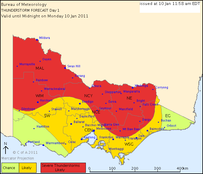
- IDV65675.gif (16.99 KiB) Viewed 17208 times
Re: SE AUS: Increasing storm potential 8/1 to 16/1
Posted: Mon Jan 10, 2011 12:41 pm
by Meso
Like the look of that chart. Would be much better on a clear day tho. Just looking at the sat pic and thinking anything that gets going will most likely be embedded amongst all the other junk.
Happily be proved wrong, but hard to excited about storms you can't really get a proper look at.
Re: SE AUS: Increasing storm potential 8/1 to 16/1
Posted: Mon Jan 10, 2011 12:56 pm
by flatcam
Meso wrote:Like the look of that chart. Would be much better on a clear day tho. Just looking at the sat pic and thinking anything that gets going will most likely be embedded amongst all the other junk.
Happily be proved wrong, but hard to excited about storms you can't really get a proper look at.
Yeah, you're most likely going to be right. Would be a bit of a bummer though just seeing the base and none of the structure above.

Never mind, hopefully by some miracle it might clear up a bit.
Also, the chart looks very nice!
Cheers, Cam
Re: SE AUS: Increasing storm potential 8/1 to 16/1
Posted: Mon Jan 10, 2011 3:23 pm
by stratospear
Some explosive storm development in Western NSW this afternoon. Meanwhile back in Vic, Seymour and Shepparton look to be in the firing line along convergent line heading SSW.
Re: SE AUS: Increasing storm potential 8/1 to 16/1
Posted: Fri Jan 14, 2011 1:01 am
by Hamlan
Chase updates, too tired to post pics.
12th Jan - John and I chased Jerilderie and scored a pair of supercells, one a beautifully structured surface based HP simultaneous with a small and higher based classic to its east.
13th Jan - We chased an incredible surface based classic supercell from Deniliquin through Echuca to north of Heathcote and lets just say it was a US style storm
Pics to come.
Brad.
Re: SE AUS: Increasing storm potential 8/1 to 16/1
Posted: Fri Jan 14, 2011 10:25 pm
by Hamlan


