JS, any idea what the hook was?

Welcome New Members! We want to hear from you. Register, stop lurking and start posting!
VIC - Strong fronts and possible low: May 7-12 2019
-
Didjman

- Supercell
- Reactions:
- Posts: 2099
- Joined: Fri Sep 03, 2010 2:52 pm
- Location: Wallan, Vic 328m ASL
- Contact:
Re: Strong fronts and possible low: May 7-12
- JasmineStorm
- Supercell
- Reactions:
- Posts: 1870
- Joined: Thu Sep 22, 2016 9:40 pm
- Location: Kyneton 527 ASL
Re: Strong fronts and possible low: May 7-12
There didn't seem to be a an overall Mesocyclone signature so I think the hook was the rear flank of a gust front that came off the bay. Great spotting again
- StratoBendigo
- Supercell
- Reactions:
- Posts: 2809
- Joined: Fri Jan 02, 2015 2:18 pm
- Location: Kangaroo Flat
Re: Strong fronts and possible low: May 7-12
15mm since yesterday which means 18mm for the week. We've had a few rain showers this afternoon to salvage it.
A cold and windy 10c. Feels like 4c. Brrrr....
A cold and windy 10c. Feels like 4c. Brrrr....
- Lara_Hunter
- Cumulus
- Reactions:
- Posts: 77
- Joined: Tue Dec 15, 2009 10:03 am
- Location: Lara
Re: Strong fronts and possible low: May 7-12
Very happy with the 43mm in Lara from 8pm last night till now. Our friends up between Anakie and Ballan tipped out 85mm at lunchtime today, they needed this bigtime, and given the next two weeks the sun should be out, should set them up well for the year. Bloody awesome.
Re: Strong fronts and possible low: May 7-12
Caught the city downpour at Vic market. Elizabeth St was awash with heavy flash flooding. More like 15-20 mm there around 1pm than the 8mm so far at Olympic Pk.
Anyone seen the photos of the Cape Paterson hailstorm? The culprit mentioned earlier by HB.
Anyone seen the photos of the Cape Paterson hailstorm? The culprit mentioned earlier by HB.
- Gordon
- Supercell
- Reactions:
- Posts: 2887
- Joined: Thu Jun 17, 2010 10:01 am
- Location: Near Gordon, Vic. 620 m asl
Re: Strong fronts and possible low: May 7-12
Good to see a few more healthy totals showing up!
Another 29mm here since 9am to add to our 38mm overnight - the rain has cleared I think, so ACCESS-C nailed it for our area. Now reached 147mm mtd, which smashes our 22 year May record, and we're only 10 days in.
Another interesting stat. is we've almost reached our end of April average of 215mm. (We still have to make up 70-odd mm by the end of May to stay on track, but at least it now seems possible.)
-
Onetahuti

- Supercell
- Reactions:
- Posts: 2790
- Joined: Thu Mar 25, 2010 9:37 pm
- Location: Dandenong Nth.
Re: Strong fronts and possible low: May 7-12
7.2mm so far today. Garden had a water, tanks topped up, I made it both ways to see partner in nursing home so I am happy.
- Wilko
- Supercell
- Reactions:
- Posts: 1492
- Joined: Wed Aug 11, 2010 12:08 pm
- Location: Moorabbin & Highett, Vic
Re: Strong fronts and possible low: May 7-12
Wow 85mm good news for that side of town !Lara_Hunter wrote: ↑Fri May 10, 2019 4:49 pm Very happy with the 43mm in Lara from 8pm last night till now. Our friends up between Anakie and Ballan tipped out 85mm at lunchtime today, they needed this bigtime, and given the next two weeks the sun should be out, should set them up well for the year. Bloody awesome.
- Macedonian
- Supercell
- Reactions:
- Posts: 2330
- Joined: Mon Dec 21, 2009 10:44 pm
- Location: Mount Macedon Vic at 870m above sea level
Re: Strong fronts and possible low: May 7-12
Looks like its calming down now. 44mm for me and the coldest day of the year with a temp range of 3.9C to a max of 6.5C briefly but mostly in the 5s all day.
Very welcome rain. Over the moon about it.
Very welcome rain. Over the moon about it.
Home- "Shepherd's Bush" at Mt Macedon. 870m
Work- "Bolobek" at Macedon. 430m
Work- "Bolobek" at Macedon. 430m
-
hillybilly

- Site Admin/Moderator
- Reactions:
- Posts: 4978
- Joined: Thu Nov 26, 2009 7:26 am
- Location: Howden Tasmania, 25m above sea level
- Contact:
Re: Strong fronts and possible low: May 7-12
Scored one more cracking shower/storm which dropped a quick 15mm. Quite small, so bit hit and miss locally. This part of the event on 25mm which is basically the inch I was expecting (plus 12mm a couple of days earlier). Looks to be pretty much cleared now, though expect the odd shower as we go more westerly into tomorrow.
Locally quite patchy, mainly in the 15-30mm range. Too southerly for us, so was never going to favour our area.
Max of 9.3C here today, which is our coldest for the year. Not that unusual for May, but still nice to get btw surprised how little snow fell in the alps today. Cut off air has warmed quickly with the strong latent heating. Snowline east of Melbourne looks to have been around 1400m, while the cold pool as it came across western Vic was cold enough for snow below 1000m.
Locally quite patchy, mainly in the 15-30mm range. Too southerly for us, so was never going to favour our area.
Max of 9.3C here today, which is our coldest for the year. Not that unusual for May, but still nice to get
- Dane
- Supercell
- Reactions:
- Posts: 1661
- Joined: Thu Nov 26, 2009 9:51 am
- Location: Sebastopol 420m ASL
- Contact:
Re: Strong fronts and possible low: May 7-12
Not only have we had over 60mm's of rain in the last 24 hours it was also the first day this year that we
failed to reach double figures. Max here was 8.7c - Airport hit 9.1c.
failed to reach double figures. Max here was 8.7c - Airport hit 9.1c.
-
hillybilly
- Site Admin/Moderator
- Reactions:
- Posts: 4978
- Joined: Thu Nov 26, 2009 7:26 am
- Location: Howden Tasmania, 25m above sea level
- Contact:
Re: Strong fronts and possible low: May 7-12
Drizzly and foggy morning in FC with another mm and a bit in the gauge. Looks like a damp day up here, which is welcome
Btw so amazing photos from Cape Paterson on Twitter etc. here are some of the more amazing ones. Looks like the peak rainfall in that areas was about 101mm. Imagine getting that much precip as mostly hail


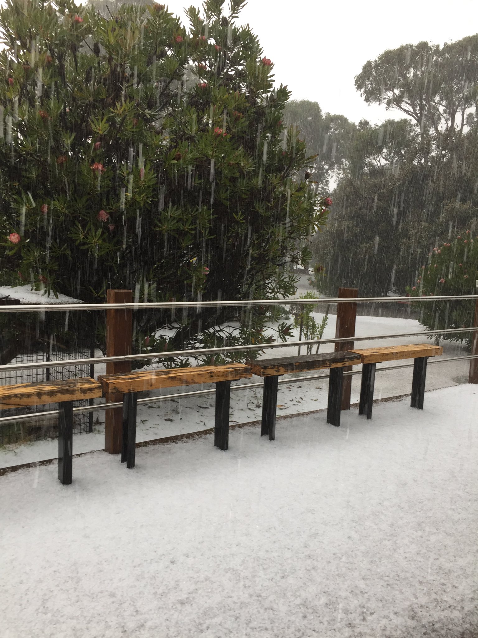
Btw so amazing photos from Cape Paterson on Twitter etc. here are some of the more amazing ones. Looks like the peak rainfall in that areas was about 101mm. Imagine getting that much precip as mostly hail
-
Didjman
- Supercell
- Reactions:
- Posts: 2099
- Joined: Fri Sep 03, 2010 2:52 pm
- Location: Wallan, Vic 328m ASL
- Contact:
Re: Strong fronts and possible low: May 7-12
Our rainfall totals for the event are:
Manual gauge - 37.6mm
PWS - 31.24 mm
best rain for the year!
Manual gauge - 37.6mm
PWS - 31.24 mm
best rain for the year!
- JasmineStorm
- Supercell
- Reactions:
- Posts: 1870
- Joined: Thu Sep 22, 2016 9:40 pm
- Location: Kyneton 527 ASL
Re: Strong fronts and possible low: May 7-12
Nice shots HB, an incredible cell it was. This was my favourite pic that I saw... they needed something better than a shovel for that much hail 
- Attachments
-
- Hail 1005.jpg (245.58 KiB) Viewed 11363 times
Re: Strong fronts and possible low: May 7-12
27 mm for this system here, very nice indeed.
bom 10 day and more so EC 10 day trying to make something happen
later next weekend, could do anything though.
Cheers Chris
bom 10 day and more so EC 10 day trying to make something happen
later next weekend, could do anything though.
Cheers Chris
-
hillybilly
- Site Admin/Moderator
- Reactions:
- Posts: 4978
- Joined: Thu Nov 26, 2009 7:26 am
- Location: Howden Tasmania, 25m above sea level
- Contact:
Re: Strong fronts and possible low: May 7-12
2mm more yesterday with a drizzly and foggy day. Max of 9.8C so two sum tens in a row
Another sneaky front for today should give a couple more mm’s here before the big high comes in. Good grass growing weather this week, with mild temperatures and partly cloudy days. Next system not for a week going by EC
Btw wierd weather in the tropics with TC Lili fading near East Timor and another deep low developing off Queensland. This one could well bring significant rain to Cape York and even the Top End. Not “normal” May weather
-
Didjman
- Supercell
- Reactions:
- Posts: 2099
- Joined: Fri Sep 03, 2010 2:52 pm
- Location: Wallan, Vic 328m ASL
- Contact:
Re: Strong fronts and possible low: May 7-12
I was watching TC Lilis formation last week and the Bom Synoptic had nothing there! I thought our TC season finished in April.... Weirdhillybilly wrote: ↑Sun May 12, 2019 7:11 am
Btw wierd weather in the tropics with TC Lili fading near East Timor and another deep low developing off Queensland. This one could well bring significant rain to Cape York and even the Top End. Not “normal” May weather
- Macedonian
- Supercell
- Reactions:
- Posts: 2330
- Joined: Mon Dec 21, 2009 10:44 pm
- Location: Mount Macedon Vic at 870m above sea level
Re: Strong fronts and possible low: May 7-12
I havent had a max above 10C since friday 3/5. It has been quite a cold grey week.hillybilly wrote: ↑Sun May 12, 2019 7:11 am 2mm more yesterday with a drizzly and foggy day. Max of 9.8C so two sum tens in a row
Another sneaky front for today should give a couple more mm’s here before the big high comes in. Good grass growing weather this week, with mild temperatures and partly cloudy days. Next system not for a week going by EC
Btw wierd weather in the tropics with TC Lili fading near East Timor and another deep low developing off Queensland. This one could well bring significant rain to Cape York and even the Top End. Not “normal” May weather
Looks like that will change this week.
Home- "Shepherd's Bush" at Mt Macedon. 870m
Work- "Bolobek" at Macedon. 430m
Work- "Bolobek" at Macedon. 430m
- Gordon
- Supercell
- Reactions:
- Posts: 2887
- Joined: Thu Jun 17, 2010 10:01 am
- Location: Near Gordon, Vic. 620 m asl
Re: Strong fronts and possible low: May 7-12
2mm here as well - we seem to be back to getting rain (or at least quantities) more than expected, not the other way around!
-
hillybilly
- Site Admin/Moderator
- Reactions:
- Posts: 4978
- Joined: Thu Nov 26, 2009 7:26 am
- Location: Howden Tasmania, 25m above sea level
- Contact:
Re: Strong fronts and possible low: May 7-12
0.4mm yesterday, with a fairly mild max of 12C. Looks like. Dry (mostly) seven days head Shame as it has been wetting up nicely. Out MTD is about 75mm so off to a good start, but still about 40mm to the average.
TC Ann Cat 2. Cant recall a May TC impacting the Queensland coast, but my memory for such things isn’t great
TC Ann Cat 2. Cant recall a May TC impacting the Queensland coast, but my memory for such things isn’t great