
Welcome New Members! We want to hear from you. Register, stop lurking and start posting!
Victoria - More heat and then some rain? - January 2nd to 5th 2020
- stevco123
- Supercell
- Reactions:
- Posts: 2936
- Joined: Sat Aug 07, 2010 7:42 pm
- Location: Cranbourne 78m asl
Re: Victoria - More heat and then some rain? - January 2nd to 5th 2020
Unfortunately it looks like we have three more days of this smoke, although it should clear up a little tomorrow and Wednesday. Thursday could be similar to today with winds coming almost directly from the east. Today's smoke is from the fires in Tasmania mainly
https://www.weatherlink.com/bulletin/53 ... 76dd68e8bc: for current weather updated every 2 minutes
Re: Victoria - More heat and then some rain? - January 2nd to 5th 2020
I cannot ever recall having a woodfire burning inside the house on 2 consecutive days in January, not a roaring fire but a gentle fire to take the nip off the air, and my 2 cats have not departed from the front of it  Nice problem to have knowing I despise the summer heat so.
- snowfall
- Supercell
- Reactions:
- Posts: 1286
- Joined: Mon Mar 20, 2017 7:39 pm
- Location: Gisborne South (349m asl)
Re: Victoria - More heat and then some rain? - January 2nd to 5th 2020
It sure is a weird day. We've been shrouded in fog and smoke all day, and then drizzle this evening, which had produced 0.6mm so far. Made it to just 13.3c today and now 12.7c. This is two days now with the heating on, as if it were winter!
- QldTwister
- Cumulonimbus
- Reactions:
- Posts: 434
- Joined: Tue May 22, 2012 7:56 pm
- Location: Ashwood Vic
Re: Victoria - More heat and then some rain? - January 2nd to 5th 2020
Crazy day felt like London in Dec Jan
14mm last 2 days nice, but much rather it fell in the Mallee and East Gippy
Big falls of 20-40mm in a thin strip in SA best falls in over a year
No big heat for coming week or so but strong fronts and warm days generally moderate weather
14mm last 2 days nice, but much rather it fell in the Mallee and East Gippy
Big falls of 20-40mm in a thin strip in SA best falls in over a year
No big heat for coming week or so but strong fronts and warm days generally moderate weather
Bring on the heat and stroms
Re: Victoria - More heat and then some rain? - January 2nd to 5th 2020
yeah bring on the heat and STROMS
referring to your signature lol ..i love stroms!
referring to your signature lol ..i love stroms!
-
hillybilly

- Site Admin/Moderator
- Reactions:
- Posts: 4984
- Joined: Thu Nov 26, 2009 7:26 am
- Location: Howden Tasmania, 25m above sea level
- Contact:
Re: Victoria - More heat and then some rain? - January 2nd to 5th 2020
Called yesterday's max too early with the temperature rising through the night. Was ~13C when I left home. Some serious fog action happening - viz down to around 50m this morning.
Dribbles overnight left 2.8mm in the gauge. Our total for the event is 20.0mm Maybe a dribble or two to come.
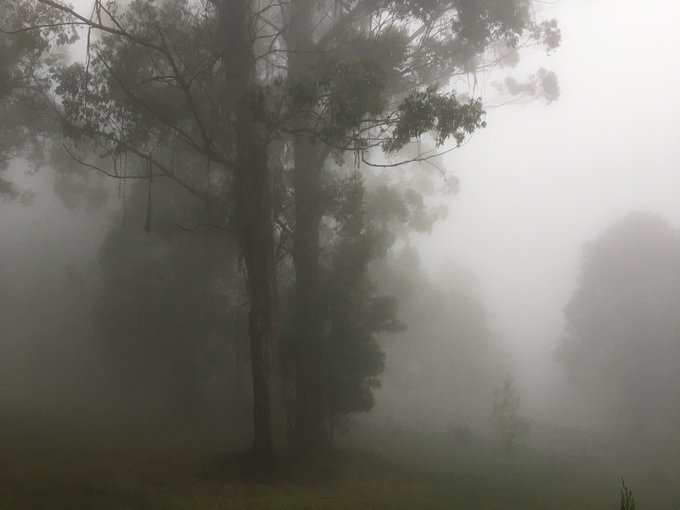
New thread time.
A photo from this morning. Had to slow down to 40km/hr driving down the hill. The fog was sat at about 300m so quite low.
Dribbles overnight left 2.8mm in the gauge. Our total for the event is 20.0mm
New thread time.
A photo from this morning. Had to slow down to 40km/hr driving down the hill. The fog was sat at about 300m so quite low.
- Macedonian
- Supercell
- Reactions:
- Posts: 2330
- Joined: Mon Dec 21, 2009 10:44 pm
- Location: Mount Macedon Vic at 870m above sea level
Re: Victoria - More heat and then some rain? - January 2nd to 5th 2020
2mm overnight so now the event total is 20mm. Excellent for my garden and even better are the cold mist-bound days so the soil doesnt dry right out again.
Home- "Shepherd's Bush" at Mt Macedon. 870m
Work- "Bolobek" at Macedon. 430m
Work- "Bolobek" at Macedon. 430m
- snowfall
- Supercell
- Reactions:
- Posts: 1286
- Joined: Mon Mar 20, 2017 7:39 pm
- Location: Gisborne South (349m asl)
Re: Victoria - More heat and then some rain? - January 2nd to 5th 2020
Another 1.5mm yesterday evening and overnight to give an event total of 20.9mm. Was misty and smoky this morning, but is clearer now though cloudy with occasional light drizzle. Currently 15c, so gradually warming up after the wintry couple of days we’ve just had.
- Tassiedave
- Supercell
- Reactions:
- Posts: 1098
- Joined: Thu Nov 11, 2010 11:09 am
- Location: Grindelwald Tasmania
Re: Victoria - More heat and then some rain? - January 2nd to 5th 2020
Tas temps today: Launceston 25.7, Cressy 25.6, Fingal 24.2, Friendly Beaches 23.9, Scottsdale 22.9, St Helens 21.2, Hobart 19.3
-
hillybilly
- Site Admin/Moderator
- Reactions:
- Posts: 4984
- Joined: Thu Nov 26, 2009 7:26 am
- Location: Howden Tasmania, 25m above sea level
- Contact:
Re: Victoria - More heat and then some rain? - January 2nd to 5th 2020
Remarkable the contrast with southern Vic. We’ve struggled up to 14.5C here today under thick fog which didn’t clear.Tassiedave wrote: ↑Tue Jan 07, 2020 6:38 pm Tas temps today: Launceston 25.7, Cressy 25.6, Fingal 24.2, Friendly Beaches 23.9, Scottsdale 22.9, St Helens 21.2, Hobart 19.3
Looks like drizzle and showers will reestablish overnight. Could well add up in the South Gippsland Hills, Central ranges etc. Front for Friday is speeding up which reduces the chances for thunderstorms on the change and the prefrontal temps.