Today's hail and showers added another 5mm in the gauge.
Temp down to 7c. Freezing.

Welcome New Members! We want to hear from you. Register, stop lurking and start posting!
Series of cold fronts 23-30 April
- StratoBendigo
- Supercell
- Reactions:
- Posts: 2810
- Joined: Fri Jan 02, 2015 2:18 pm
- Location: Kangaroo Flat
- Macedonian
- Supercell
- Reactions:
- Posts: 2330
- Joined: Mon Dec 21, 2009 10:44 pm
- Location: Mount Macedon Vic at 870m above sea level
Re: Series of cold fronts 23-30 April
Max of 8C here today and only 3.5C now. Any precip that comes now could fall as snow.
Home- "Shepherd's Bush" at Mt Macedon. 870m
Work- "Bolobek" at Macedon. 430m
Work- "Bolobek" at Macedon. 430m
-
hillybilly

- Site Admin/Moderator
- Reactions:
- Posts: 4988
- Joined: Thu Nov 26, 2009 7:26 am
- Location: Howden Tasmania, 25m above sea level
- Contact:
Re: Series of cold fronts 23-30 April
Max of 8.8C here. Most the arvo was between 6 and 7C, and now on 5C. Nice polar low just south of Cape Otway with a central core of convection moving towards central areas, while a bit further west sits a 200 to 250km/hr north-south polar jet. That is brutal, and in mid winter would set us up for a decent low level snow event. Unfortunately the oceans are still warm from summer and the Antarctic Sea Ice is still well south so the airmass will be substantially modified before it gets here. Still, could well see approaches on early season records for max and mins the next few days. The freezing level is headed down to about 900m, perhaps 850 for a while tomorrow, so the usual subalpine spots will get some snow. Probably 0.5 to 1C too warm here, but could get some sleet and likely graupel.
Major surge event on the coast. Looks like the high tide tomorrow night could get to within 10-20cm of the Bay record from June 2015. That was around 1.6 on the bay winds graph The lower Dandenong Creek, Elwood canal and lower Yarra could have issues if this comes with heavy rain (I’m expecting substantial rain, but will come down to its persistence and how the bands stream).
Major surge event on the coast. Looks like the high tide tomorrow night could get to within 10-20cm of the Bay record from June 2015. That was around 1.6 on the bay winds graph
- snowfall
- Supercell
- Reactions:
- Posts: 1287
- Joined: Mon Mar 20, 2017 7:39 pm
- Location: Gisborne South (349m asl)
Re: Series of cold fronts 23-30 April
3mm here today. No hail that I noticed but a chilly day. It briefly reached 12c with a burst of sun, but much the day was sub 10c. Was 6c about an hour ago but has snuck up to 7c as the wind is now increasing.
Finished on 147mm for April. Great to have yet another month well above average. YTD is 468mm. We also ended up 2c below average for the maximum temp and just over half a degree below for the minimum temp. Average max for this month came in at 16.4c and average min at 8.2c. Feb, March, and now April have all been about 2c below, which is quite a run.
Finished on 147mm for April. Great to have yet another month well above average. YTD is 468mm. We also ended up 2c below average for the maximum temp and just over half a degree below for the minimum temp. Average max for this month came in at 16.4c and average min at 8.2c. Feb, March, and now April have all been about 2c below, which is quite a run.
- Dane
- Supercell
- Reactions:
- Posts: 1661
- Joined: Thu Nov 26, 2009 9:51 am
- Location: Sebastopol 420m ASL
- Contact:
Re: Series of cold fronts 23-30 April
Had a Max of 10.7c today - forecast Max tomorrow is 7c.
Just had a fairly heavy shower here and temp is now down to 5.2c.
Just had a fairly heavy shower here and temp is now down to 5.2c.
- Gordon
- Supercell
- Reactions:
- Posts: 2890
- Joined: Thu Jun 17, 2010 10:01 am
- Location: Near Gordon, Vic. 620 m asl
Re: Series of cold fronts 23-30 April
Down to 3C here with the odd snowy blob in the constant rain; reckon we'll beat 9am this morning with 9am tomorrow at this rate!
- QldTwister
- Cumulonimbus
- Reactions:
- Posts: 434
- Joined: Tue May 22, 2012 7:56 pm
- Location: Ashwood Vic
Re: Series of cold fronts 23-30 April
Boy its chilly out there but gonna get much colder and wilder, had a nice hail shower in the city with pea size hail with those showers, sure be much more tomorrow
2mm from showers today so not much but wet night and tomorrow on the way locally.
First rain band will hit metro in coming hours then its just wave after wave of rain gales bit of hail and thunder with coldies localised streams of heavy rain setting up. Parts of the south will see 30-50mm to come even more for those under these convergent streams wild 36 hours ahead
More Saturday but easing and not much come Sunday
Sunny days next week yay
45mm of rain yesterday 198mm for the month
So wet can we all take a moment and look at the huge numbers we are all getting atm just crazy
2nd wettest Jan to Apr on record for Melb
Wettest April for Melb since 1960 thats 60 years
More rain to come, flooding in the NE, amazing event and another wild 48 hours ahead
Winds are going to be nuts and easy 50cm i the Alps and good low level snow too so enjoy all
Winds are HOWLING outside atm has come from no where
Bring on the heat and stroms
- Macedonian
- Supercell
- Reactions:
- Posts: 2330
- Joined: Mon Dec 21, 2009 10:44 pm
- Location: Mount Macedon Vic at 870m above sea level
Re: Series of cold fronts 23-30 April
Snowing well and 2.4C now.
Home- "Shepherd's Bush" at Mt Macedon. 870m
Work- "Bolobek" at Macedon. 430m
Work- "Bolobek" at Macedon. 430m
-
hillybilly
- Site Admin/Moderator
- Reactions:
- Posts: 4988
- Joined: Thu Nov 26, 2009 7:26 am
- Location: Howden Tasmania, 25m above sea level
- Contact:
Re: Series of cold fronts 23-30 April
Not surprised. We are down to 3.8C here with thick rain and the odd slushy drop. About 1C too warm for snow, so would put the snow line around 700m atm.
- Macedonian
- Supercell
- Reactions:
- Posts: 2330
- Joined: Mon Dec 21, 2009 10:44 pm
- Location: Mount Macedon Vic at 870m above sea level
Re: Series of cold fronts 23-30 April
Down to 1.7C now.
Home- "Shepherd's Bush" at Mt Macedon. 870m
Work- "Bolobek" at Macedon. 430m
Work- "Bolobek" at Macedon. 430m
-
hillybilly
- Site Admin/Moderator
- Reactions:
- Posts: 4988
- Joined: Thu Nov 26, 2009 7:26 am
- Location: Howden Tasmania, 25m above sea level
- Contact:
Re: Series of cold fronts 23-30 April
15mm in the gauge this morning with fog and rain continuing. Currently 3.3C so cold enough for sleet and perhaps the odd flake if we score a convective shower. Snow would be falling to around 600m given those numbers and settling to around 700m atm. Coldest air still an hour or two out so might drop a bit lower. One of those events where another degree colder would make a big difference (these events show why the Nongs used to get so much more snow  ).
).
Cold wet windy 48 hours coming up. Initially we have cyclonic cold air advection, but this reverts to cyclonic warm air advection. Showers should transition to thick drizzle about 24 hours from now.
Expecting another 20-40mm here, so could crack 100mm for the event. Great event for charging the soil moisture and runoff Sets us up with a decent chance for a wet May.
Looking forward to the snow photos from those who live a bit higher than me
Watching the surge to see how high it goes. This morning will likely get to around 1.2m in the bay, and 1.4 tonight. Unfortunately dark for the peak. Would expect waves onto the bike paths and back fences.
Btw citiy’s 4.8mm means it only need 3.2mm to equal the YTD record high. Should get that today. Stunning turnaround from last year when we had the driest start to a year on record. Record dry to record wet would be a crazy stat to score. Indian Ocean has flipped from a near record positive IOD to near record warm water off Australia (and pretty likely negative IOD).
Cold wet windy 48 hours coming up. Initially we have cyclonic cold air advection, but this reverts to cyclonic warm air advection. Showers should transition to thick drizzle about 24 hours from now.
Expecting another 20-40mm here, so could crack 100mm for the event. Great event for charging the soil moisture and runoff
Looking forward to the snow photos from those who live a bit higher than me
Watching the surge to see how high it goes. This morning will likely get to around 1.2m in the bay, and 1.4 tonight. Unfortunately dark for the peak. Would expect waves onto the bike paths and back fences.
Btw citiy’s 4.8mm means it only need 3.2mm to equal the YTD record high. Should get that today. Stunning turnaround from last year when we had the driest start to a year on record. Record dry to record wet would be a crazy stat to score. Indian Ocean has flipped from a near record positive IOD to near record warm water off Australia (and pretty likely negative IOD).
-
hillybilly
- Site Admin/Moderator
- Reactions:
- Posts: 4988
- Joined: Thu Nov 26, 2009 7:26 am
- Location: Howden Tasmania, 25m above sea level
- Contact:
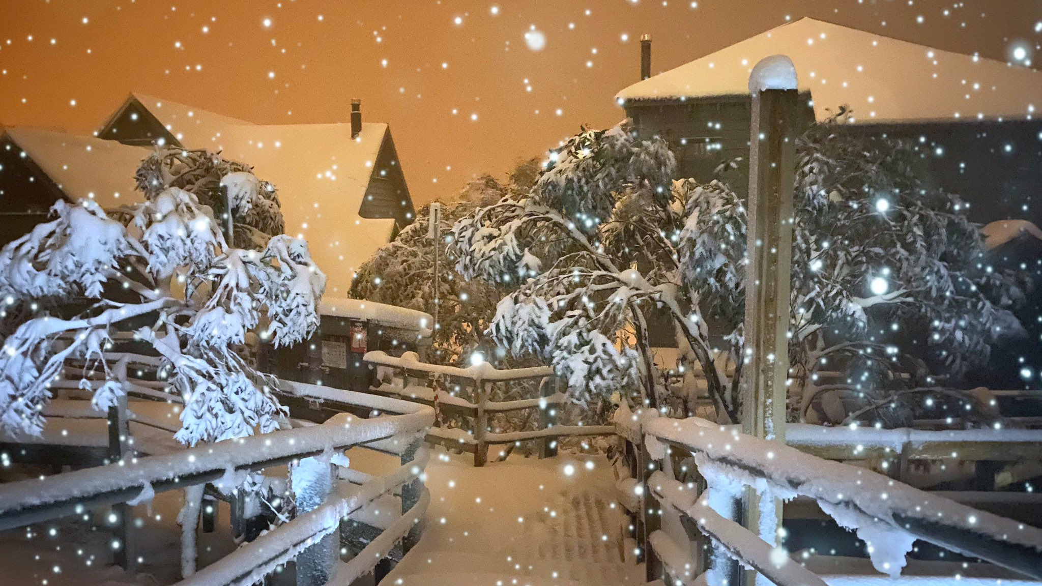
Re: Series of cold fronts 23-30 April
Mt Hotham this morning. Hope to see plenty more photos filter in
- Skywalker
- Supercell
- Reactions:
- Posts: 1872
- Joined: Sun Nov 29, 2009 10:03 am
- Location: Burnside Heights/Cowes (Home) & Sunshine West (Work)
Re: Series of cold fronts 23-30 April
What a great picture, looks like a Christmas wonderland in May.
Thought for a moment you took that shot HB. Would be nice though if you got that opportunity during this event up there in FC.
Grey, bleak, cold & wet. Probably won't get hail here, but the south eastern suburbs would be a target at some point today.
Thought for a moment you took that shot HB. Would be nice though if you got that opportunity during this event up there in FC.
Grey, bleak, cold & wet. Probably won't get hail here, but the south eastern suburbs would be a target at some point today.
Caroline Springs, Melbourne's meteorological boredom zone.
-
hillybilly
- Site Admin/Moderator
- Reactions:
- Posts: 4988
- Joined: Thu Nov 26, 2009 7:26 am
- Location: Howden Tasmania, 25m above sea level
- Contact:
Re: Series of cold fronts 23-30 April
18mm in the gauge for the 24 hours. That makes 11, 27 and 18mm so far (plus the ~35mm last weekend which is part of the thread). Guess that makes 91mm Gauge has around 2mm of ice still in it from a heavy sleet and graupel shower and 8am and more heavy shower inbound so will go well past the 100mm I think.
City on 7.8mm - need 0.2mm to equal the YTD record
City on 7.8mm - need 0.2mm to equal the YTD record
- Macedonian
- Supercell
- Reactions:
- Posts: 2330
- Joined: Mon Dec 21, 2009 10:44 pm
- Location: Mount Macedon Vic at 870m above sea level
Re: Series of cold fronts 23-30 April
Still got some lovely snow showers happening this morning. No settling though.
1.9C at the mo.
Dead calm, no wind here at all in the last few days.
1.9C at the mo.
Dead calm, no wind here at all in the last few days.
Home- "Shepherd's Bush" at Mt Macedon. 870m
Work- "Bolobek" at Macedon. 430m
Work- "Bolobek" at Macedon. 430m
- flyfisher
- Cumulonimbus
- Reactions:
- Posts: 250
- Joined: Wed Jul 18, 2012 1:39 pm
- Location: Belgrave
- Contact:
Re: Series of cold fronts 23-30 April
Lots of rain over night - great to hear it on the new roof and see the creek in flood. But cannot check the radar as a truck took out the copper line which is lying on the ground. Telstra won't fix until 7 May, so have come into work to speak to the Ombudsman - how do we home school/work from home? Also mobile phone black spot at home.
Stay stafe!
Stay stafe!
- StratoBendigo
- Supercell
- Reactions:
- Posts: 2810
- Joined: Fri Jan 02, 2015 2:18 pm
- Location: Kangaroo Flat
Re: Series of cold fronts 23-30 April
Equalled it at 8:50am!hillybilly wrote: ↑Fri May 01, 2020 8:49 am 18mm in the gauge for the 24 hours. That makes 11, 27 and 18mm so far (plus the ~35mm last weekend which is part of the thread). Guess that makes 91mm
City on 7.8mm - need 0.2mm to equal the YTD record
Anyway, 7c and occasional light showers of rain at present. Nothing substantial since we're in a rain shadow today.
- Gordon
- Supercell
- Reactions:
- Posts: 2890
- Joined: Thu Jun 17, 2010 10:01 am
- Location: Near Gordon, Vic. 620 m asl
Re: Series of cold fronts 23-30 April
That is the pits flyfisher . Good luck getting it sorted.
Another 18mm here, a few flakes in the rain but nothing to speak of so far. Have to head out for a couple of appointments so hope I don't miss anything!
Another 18mm here, a few flakes in the rain but nothing to speak of so far. Have to head out for a couple of appointments so hope I don't miss anything!
- Dane
- Supercell
- Reactions:
- Posts: 1661
- Joined: Thu Nov 26, 2009 9:51 am
- Location: Sebastopol 420m ASL
- Contact:
Re: Series of cold fronts 23-30 April
17.4mm's of Rain up to 9am here so good start to May. Temp been around 5c for most of the night but edged up to 5.7c at 10am
Was officially Ballarat's wettest April since 1995, daytime temps were 1.5c below normal but night time temps just 0.2c below average.
Was officially Ballarat's wettest April since 1995, daytime temps were 1.5c below normal but night time temps just 0.2c below average.
- BringOnTheCoolChange
- Cumulonimbus
- Reactions:
- Posts: 216
- Joined: Fri Jul 18, 2014 9:27 pm
- Location: East Warburton, Victoria, asl 232m
Re: Series of cold fronts 23-30 April
Was 5c this morning in East Warby near the redwoods.