Decent change showing up in the progs with a front approaching on Friday with winds freshening and some showers developing, moving through on Saturday with a band of rain or showers followed by a cold showery 24 hours. The system is quite cold, with 850Ts dipping to around -3C on Saturday evening into Sunday so should see some coldies, the odd thundery and some small hail. Bit of snow in the alps, that could drop close to the top of spots like Macedon.
There isn’t a lot of moisture feeding into the system and it tends to peak to our west so won’t be a big rain producer. That said, the upper trough is sharp, so there is a chance the system could slow down and wave.
Before then, a couple of mild sunny to partly cloudy days.

Welcome New Members! We want to hear from you. Register, stop lurking and start posting!
Becoming windy with a strong change: May 7-11
-
hillybilly

- Site Admin/Moderator
- Reactions:
- Posts: 4989
- Joined: Thu Nov 26, 2009 7:26 am
- Location: Howden Tasmania, 25m above sea level
- Contact:
- Skywalker
- Supercell
- Reactions:
- Posts: 1872
- Joined: Sun Nov 29, 2009 10:03 am
- Location: Burnside Heights/Cowes (Home) & Sunshine West (Work)
Re: Becoming windy with a strong change: May 7-11
A horrible couple of days of windy filth coming up. 
It's going to make it rather unpleasant on the bike riding home.
It's going to make it rather unpleasant on the bike riding home.
Caroline Springs, Melbourne's meteorological boredom zone.
- Gordon
- Supercell
- Reactions:
- Posts: 2890
- Joined: Thu Jun 17, 2010 10:01 am
- Location: Near Gordon, Vic. 620 m asl
Re: Becoming windy with a strong change: May 7-11
Already quite windy here (my least-favourite weather phenomena) and now a SWW for damaging winds issued for a fair chunk of southern and NE Vic.
Oh well, at least it's not 5C (yet!)
Oh well, at least it's not 5C (yet!)
-
hillybilly
- Site Admin/Moderator
- Reactions:
- Posts: 4989
- Joined: Thu Nov 26, 2009 7:26 am
- Location: Howden Tasmania, 25m above sea level
- Contact:
Re: Becoming windy with a strong change: May 7-11
Temperatures were mild but wind and cloud made today pretty unpleasant here. Tomorrow and Friday look pretty similar. Not much change for the weekend. Nice cold front with decent shot of cold air, but not a lot of moisture being tapped. Looks like 5-20mm for most, better in the usual wet spots.
-
hillybilly
- Site Admin/Moderator
- Reactions:
- Posts: 4989
- Joined: Thu Nov 26, 2009 7:26 am
- Location: Howden Tasmania, 25m above sea level
- Contact:
Re: Becoming windy with a strong change: May 7-11
Big gusts here this morning. Quite unpleasant. Gonna be some tree branches down or worse with this blow coming after a lot of rain. Next two fronts will fade as they approach, with the main event on Saturday. Progs are tending to up rain totals so a handy fall for most... not big but perhaps 5-20mm for most southern areas.
- Skywalker
- Supercell
- Reactions:
- Posts: 1872
- Joined: Sun Nov 29, 2009 10:03 am
- Location: Burnside Heights/Cowes (Home) & Sunshine West (Work)
Re: Becoming windy with a strong change: May 7-11
The disgusting filth has arrived nice & early this morning. 
Gust of 82 km/h already recorded at Melbourne Airport.
Gust of 82 km/h already recorded at Melbourne Airport.
Caroline Springs, Melbourne's meteorological boredom zone.
-
occluded

- Cumulonumbus Calvas
- Reactions:
- Posts: 611
- Joined: Tue May 04, 2010 3:26 pm
- Location: Mooroolbark 130m asl
Re: Becoming windy with a strong change: May 7-11
Filthy winds yes - but sunny weather arrived here about an hour ago.
Torn as to whether I should go out on the bike and enjoy the sun/suffer the wind before it deteriorates again
Torn as to whether I should go out on the bike and enjoy the sun/suffer the wind before it deteriorates again
- stevco123
- Supercell
- Reactions:
- Posts: 2936
- Joined: Sat Aug 07, 2010 7:42 pm
- Location: Cranbourne 78m asl
Re: Becoming windy with a strong change: May 7-11
Nowhere near as windy as i thought it'd be today. It was a lot worse yesterday
https://www.weatherlink.com/bulletin/53 ... 76dd68e8bc: for current weather updated every 2 minutes
-
hillybilly
- Site Admin/Moderator
- Reactions:
- Posts: 4989
- Joined: Thu Nov 26, 2009 7:26 am
- Location: Howden Tasmania, 25m above sea level
- Contact:
Re: Becoming windy with a strong change: May 7-11
Almost warm here today with 17C. Would have been a nice day if not for the nasty wind 
Similar tomorrow, perhaps a little warmer.
Front for Saturday still looks good. Showers look like lasting into Sunday. Gonna be another decent blow on the coast with a storm surge (which is lower than last week) but on a higher tide. Beaches will be a mess.
Similar tomorrow, perhaps a little warmer.
Front for Saturday still looks good. Showers look like lasting into Sunday. Gonna be another decent blow on the coast with a storm surge (which is lower than last week) but on a higher tide. Beaches will be a mess.
-
Australis(Shell3155)

- Supercell
- Reactions:
- Posts: 3146
- Joined: Mon Nov 30, 2009 8:05 pm
- Location: FTG
- Contact:
Re: Becoming windy with a strong change: May 7-11
Was pleased with a windy day and not a windy night,
Well unless I slept through it..
over night temps are very pleasant..
Well unless I slept through it..
over night temps are very pleasant..
-
hillybilly
- Site Admin/Moderator
- Reactions:
- Posts: 4989
- Joined: Thu Nov 26, 2009 7:26 am
- Location: Howden Tasmania, 25m above sea level
- Contact:
Re: Becoming windy with a strong change: May 7-11
Almost warm day across Vic. Last one for a while. 14C in FC with glorious sunshine. Garden looks a treat with the grass still growing, and leaves turning.
Front looks decent, moving up on the southwest atm.
Front looks decent, moving up on the southwest atm.
-
hillybilly
- Site Admin/Moderator
- Reactions:
- Posts: 4989
- Joined: Thu Nov 26, 2009 7:26 am
- Location: Howden Tasmania, 25m above sea level
- Contact:
Re: Becoming windy with a strong change: May 7-11
Radar is looking chunky with with ok falls already clocked up out west, stretching into the Wimmera. Looks like starting in Melbourne around 7 to 8am. Nice cold pool tucked in behind the front so coldies followed by a cold night. Snow falls down to a bit below 1000m. Currently down at Walkerville where I hope to cut a somewhat out of control lawn before it rains 
System didn’t quite link up with Indian Ocean moisture from the develop TC so won’t be big falls, but should keep the month ticking over. Couple more sneaky front to come before it all clears out middle of next week.
On the coast another round of big waves and a moderate storm surge sitting on some of the highest tides of the year. Could see some minor flooding again around the Bayside mid arvo, though not quite as high as last weekend.
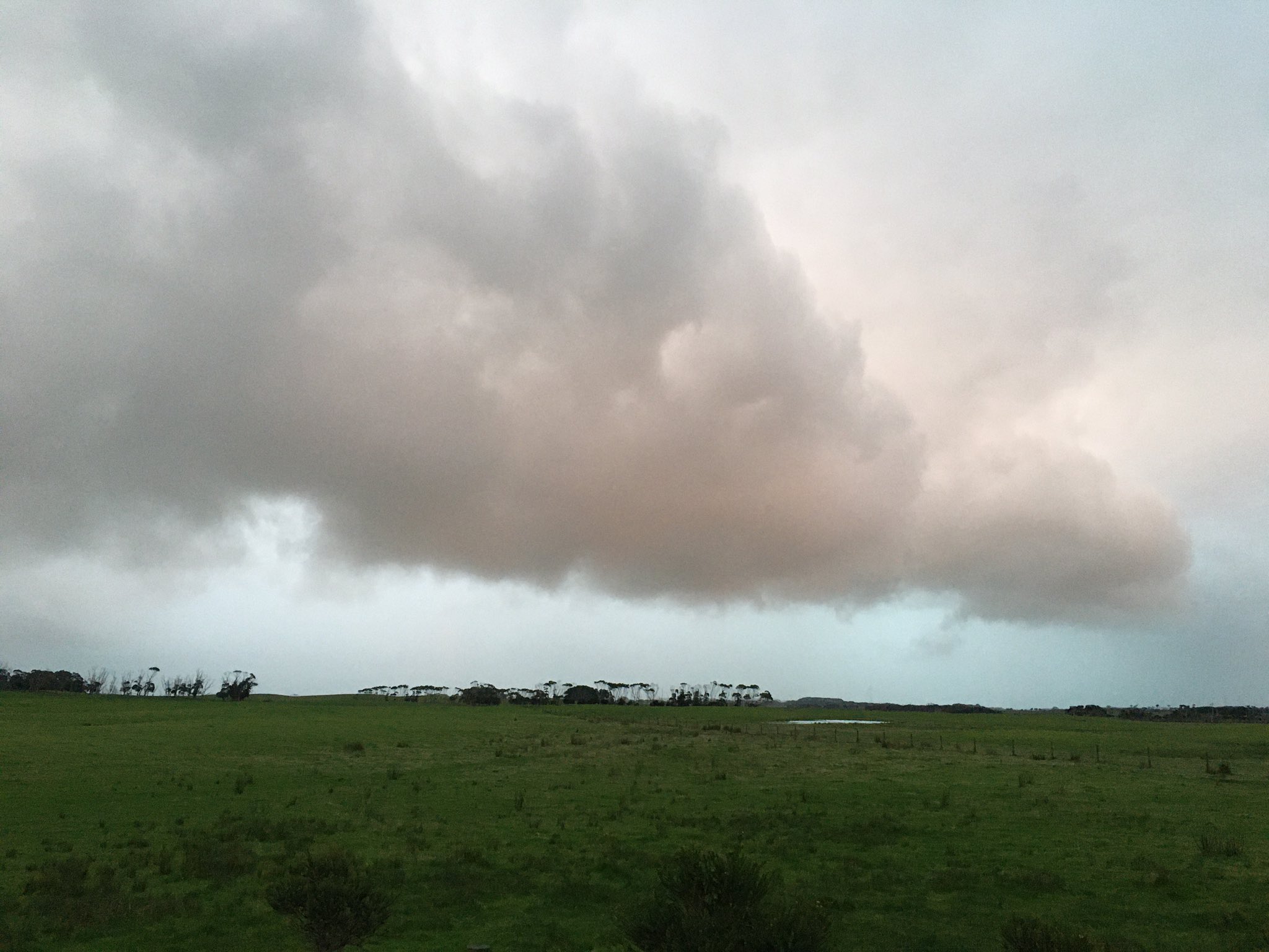
EDIT> a photo of the incoming storms at Walkerville. This is looking northwest with Inverloch and Tarwin hiding in the rain.
System didn’t quite link up with Indian Ocean moisture from the develop TC so won’t be big falls, but should keep the month ticking over. Couple more sneaky front to come before it all clears out middle of next week.
On the coast another round of big waves and a moderate storm surge sitting on some of the highest tides of the year. Could see some minor flooding again around the Bayside mid arvo, though not quite as high as last weekend.
EDIT> a photo of the incoming storms at Walkerville. This is looking northwest with Inverloch and Tarwin hiding in the rain.
- Tassiedave
- Supercell
- Reactions:
- Posts: 1099
- Joined: Thu Nov 11, 2010 11:09 am
- Location: Grindelwald Tasmania
Re: Becoming windy with a strong change: May 7-11
RAIN overnight in Tas: Pine Tree Rivulet 45mm, Strahan 36mm, Mt Barrow 21mm, Devonport 17mm, Wynyard 15mm, Launceston 10mm, Hobart 2.6mm
-
Didjman

- Supercell
- Reactions:
- Posts: 2099
- Joined: Fri Sep 03, 2010 2:52 pm
- Location: Wallan, Vic 328m ASL
- Contact:
Re: Becoming windy with a strong change: May 7-11
Banding on the radar again. Rain not far off here. Currently temp 11/9. Baro 1006.5 and steady. Max wind 15klm / hr
- Gordon
- Supercell
- Reactions:
- Posts: 2890
- Joined: Thu Jun 17, 2010 10:01 am
- Location: Near Gordon, Vic. 620 m asl
Re: Becoming windy with a strong change: May 7-11
Slightly disappointed with our 7mm to 9am from the main band, but more impressed with the punch of the apparently 'little' showers following. The radar is almost operating in reverse this morning!
-
Didjman
- Supercell
- Reactions:
- Posts: 2099
- Joined: Fri Sep 03, 2010 2:52 pm
- Location: Wallan, Vic 328m ASL
- Contact:
Re: Becoming windy with a strong change: May 7-11
A massive 1.8mm since my last post! Temp has dropped 3 degrees to be on 8C.
Re: Becoming windy with a strong change: May 7-11
Front blasted through here about 11:30. 7mm in last hour. Temp 9. Wont take a lot more to get the gushers flowing again.
Some still flowing from last week's rain despite nothing since. Shows just how wet the ground is.
Some still flowing from last week's rain despite nothing since. Shows just how wet the ground is.
- snowfall
- Supercell
- Reactions:
- Posts: 1287
- Joined: Mon Mar 20, 2017 7:39 pm
- Location: Gisborne South (349m asl)
Re: Becoming windy with a strong change: May 7-11
7.2mm from the main band here and a further 2mm since. Had a decent hail shower earlier this afternoon. The sun has come out and the temp has spiked to 10c but most of the day it has hovered around 8c.
- Dane
- Supercell
- Reactions:
- Posts: 1661
- Joined: Thu Nov 26, 2009 9:51 am
- Location: Sebastopol 420m ASL
- Contact:
Re: Becoming windy with a strong change: May 7-11
8.2mm's up to 9am and just over 2mm's since then. Max was 11.2c - Airport Max was 10.9c.
Just had a slight hail shower and now 5.17pm the temp has dropped to 6.2c.
Just had a slight hail shower and now 5.17pm the temp has dropped to 6.2c.
-
hillybilly
- Site Admin/Moderator
- Reactions:
- Posts: 4989
- Joined: Thu Nov 26, 2009 7:26 am
- Location: Howden Tasmania, 25m above sea level
- Contact:
Re: Becoming windy with a strong change: May 7-11
Just on 12mm in FC and 15mm in Walkerville. Cold, wet and wintery
Down here on the coast had multiple fast moving coldies with brief hail.
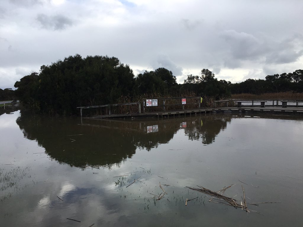
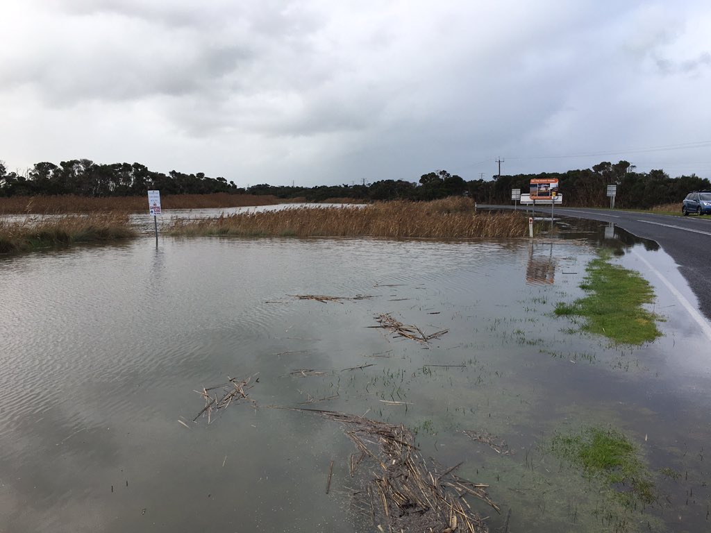
Gales and a big storm surge. Here’s some photos from Tarwin Lower near Venus Bay where the tide is the highest I’ve ever seen it (today is one of the highest tide of year and there was a storm surge of about 40cm). Inverloch Beach is a huge mess. Barely a beach there today with massive erosion The tide was still coming in when I took these photos, so probably got a touch higher.

Down here on the coast had multiple fast moving coldies with brief hail.
Gales and a big storm surge. Here’s some photos from Tarwin Lower near Venus Bay where the tide is the highest I’ve ever seen it (today is one of the highest tide of year and there was a storm surge of about 40cm). Inverloch Beach is a huge mess. Barely a beach there today with massive erosion