
Welcome New Members! We want to hear from you. Register, stop lurking and start posting!
Becoming humid with showers, storms and rain: November 22-30
Forum rules
When posting photos, particularly in active breaking weather threads, please link to clickable photos to minimise download issues. For more information, see Posting Photo Guidelines for more information. Threads that are six weeks old or older will be Archived Here
When posting photos, particularly in active breaking weather threads, please link to clickable photos to minimise download issues. For more information, see Posting Photo Guidelines for more information. Threads that are six weeks old or older will be Archived Here
- Gordon
- Supercell
- Reactions:
- Posts: 2896
- Joined: Thu Jun 17, 2010 10:01 am
- Location: Near Gordon, Vic. 620 m asl
Re: Becoming humid with showers, storms and rain: November 22-30
Ended up with 78mm for November, 7mm below average but quite acceptable after the dry start to the month.
Re: Becoming humid with showers, storms and rain: November 22-30
112mm @ 0700hrs Fri 1/12 in Sale. Nice drop of rain 
(Fig. for this rain event.)
(Fig. for this rain event.)
- Quasar217
- Stratus
- Reactions:
- Posts: 19
- Joined: Mon Nov 30, 2009 8:50 pm
- Location: Ringwood North, Vic
Re: Becoming humid with showers, storms and rain: November 22-30
Ended up with 43mm in Ringwood North, around half the November average. After a wet October and very dry September, spring overall a bit below average. Nov was on track to be the driest on record for me in 40 years, but the last week pushed it back into just "well below average" territory.
-
occluded

- Cumulonumbus Calvas
- Reactions:
- Posts: 611
- Joined: Tue May 04, 2010 3:26 pm
- Location: Mooroolbark 130m asl
Re: Becoming humid with showers, storms and rain: November 22-30
Some crazy winds locally on Wednesday afternoon/evening with strong South Easterlies coming off the Dandenongs.
Montrose and Kilsyth in the lee of the hills were particularly windy with quite a few trees down and a tin roof ending up in a neighbour's garden
Relatively calm up in the hills. After the June 2021 storm any strong SE winds make me nervous!
Montrose and Kilsyth in the lee of the hills were particularly windy with quite a few trees down and a tin roof ending up in a neighbour's garden
Relatively calm up in the hills. After the June 2021 storm any strong SE winds make me nervous!
-
Petros

- Supercell
- Reactions:
- Posts: 2001
- Joined: Tue Dec 01, 2009 6:25 pm
- Location: Maffra, Gippsland, Vic
Re: Becoming humid with showers, storms and rain: November 22-30
It rained steadily from the SE here from mid yest arvo till 8am this morning, looks like 35mm sitting in our gauge to empty out later this arvo to take us to the 5 inches mark for this event. Major flood on the Avon at Stratford right now, major flood of the Thompson at Wandocka (Gipps and Knox bridge) as well. Lake Glenmaggie released at the upper end of the moderate flood level rate for 2.5hrs earlier this morning (34,500 MLd), now back at the mid moderate flood level, saving us a major flood by a few inches, ....but at the expense of allowing Lake Glenmaggie to rise from 92.5% to 98%.
Maffra area saved by the fact the SE'ly pushing the rain was relatively light, the rain didnt push very high up into the Macalister higher catchments. But with the final clearing band of rain to impact here tomorrow (looks like 30mm+ in that!), it will be near a week before the Macalister falls below the minor flood level I reckon. Tough times for the farmers on the low lands between Maffra and Sale, but plenty of irrigation to get them through to mid autumn. Campers and water skiers will have a ball at Lake Glenmaggie this Christmas.
Maffra area saved by the fact the SE'ly pushing the rain was relatively light, the rain didnt push very high up into the Macalister higher catchments. But with the final clearing band of rain to impact here tomorrow (looks like 30mm+ in that!), it will be near a week before the Macalister falls below the minor flood level I reckon. Tough times for the farmers on the low lands between Maffra and Sale, but plenty of irrigation to get them through to mid autumn. Campers and water skiers will have a ball at Lake Glenmaggie this Christmas.
Re: Becoming humid with showers, storms and rain: November 22-30
Yes Living up the back of Mooroolbark, Montrose area, I share your nervousness, we are the same after $300000 repair to the home from a fallen tree, during that period.occluded wrote: ↑Fri Dec 01, 2023 10:45 am Some crazy winds locally on Wednesday afternoon/evening with strong South Easterlies coming off the Dandenongs.
Montrose and Kilsyth in the lee of the hills were particularly windy with quite a few trees down and a tin roof ending up in a neighbour's garden
Relatively calm up in the hills. After the June 2021 storm any strong SE winds make me nervous!
-
hillybilly

- Site Admin/Moderator
- Reactions:
- Posts: 5009
- Joined: Thu Nov 26, 2009 7:26 am
- Location: Howden Tasmania, 25m above sea level
- Contact:
Re: Becoming humid with showers, storms and rain: November 22-30
One last burst of showers tending to rain today for vic. A weak upper low will support a period of southeasterly upslide, which I expect will target particularly west Gippsland. Probably more flooding issues. Quite remarkable really for a positive IOD moderate El Niño. Expecting showers here in southeast TAS from late arvo. Probably a 25mm on mountain, 2mm on the flat system with only weak flow, but one never quite knows with these set up.
It been so humid down here now for a couple of weeks and quite strangely the local beaches are flooded with blue bottles because of the exceptionally hot and strong east Australian current and easterly winds. I don’t have a good gauge for how often this happens but don’t imagine too often. It’s rapidly becoming like south coast NSW with tuna, sail fish, urchins, morten bay bugs all establishing, while the kelp disappears.
Was interesting that despite the good rain all states and territories actually fell below average for spring. That surprised me tbh, but guess those are the stats. Does feel like the El Niño has been a bit half arsed, more like a 1987 than a 1982 or 2015. No complaints. Suspect partly a combination of luck, warm waters around a lot of Oz and the Tongan volcano.

Re: Becoming humid with showers, storms and rain: November 22-30
Tipped out another 6.75mm here yesterday to keep our event total ticking along.
Solid patch of rain here this morning, would estimate we’ve had 10mm since sunrise based on local amateur stations around the town. Good spot re: the west Gippsland focus of todays rain Hillybilly!
Update 8.50am: heavy rain has now stopped, just tipped out 20.5mm
Solid patch of rain here this morning, would estimate we’ve had 10mm since sunrise based on local amateur stations around the town. Good spot re: the west Gippsland focus of todays rain Hillybilly!
Update 8.50am: heavy rain has now stopped, just tipped out 20.5mm

- stevco123
- Supercell
- Reactions:
- Posts: 2937
- Joined: Sat Aug 07, 2010 7:42 pm
- Location: Cranbourne 78m asl
Re: Becoming humid with showers, storms and rain: November 22-30
Wet day timetable here today. Rain looks to have set in and not moving anywhere according to the radar. 5mm since midnight.
El Nino is a failure this year so far (thankfully). Media needs to stop beating its drum.
El Nino is a failure this year so far (thankfully). Media needs to stop beating its drum.
https://www.weatherlink.com/bulletin/53 ... 76dd68e8bc: for current weather updated every 2 minutes
- snowfall
- Supercell
- Reactions:
- Posts: 1292
- Joined: Mon Mar 20, 2017 7:39 pm
- Location: Gisborne South (349m asl)
Re: Becoming humid with showers, storms and rain: November 22-30
We've had thick, steady rain for hours here, although it's tending more to drizzle currently. 30mm so far overnight and this morning. Perfect soaking rain. We also had 7mm yesterday, so a good start to the month.
- stevco123
- Supercell
- Reactions:
- Posts: 2937
- Joined: Sat Aug 07, 2010 7:42 pm
- Location: Cranbourne 78m asl
Re: Becoming humid with showers, storms and rain: November 22-30
14mm and counting. Love it
https://www.weatherlink.com/bulletin/53 ... 76dd68e8bc: for current weather updated every 2 minutes
Re: Becoming humid with showers, storms and rain: November 22-30
Wet day in Bacchus, started with heavy drizzle giving way to steady moderate rain. 20mm today bringing the total to 43mm for the event.
-
Petros
- Supercell
- Reactions:
- Posts: 2001
- Joined: Tue Dec 01, 2009 6:25 pm
- Location: Maffra, Gippsland, Vic
Re: Becoming humid with showers, storms and rain: November 22-30
Not to mention the transition into a solar Maunder Minimum climate as we wheel towards 2050 ever cooling.hillybilly wrote: ↑Sat Dec 02, 2023 5:44 am
.........Does feel like the El Niño has been a bit half arsed, more like a 1987 than a 1982 or 2015. No complaints. Suspect partly a combination of luck, warm waters around a lot of Oz and the Tongan volcano.
This event keeps on delivering for Nth Central Gippsland, I just tipped out another 17mm for last 24hrs, takes Maffra to 143mm for last 7 days plus today. We have just now returned to mid range moderate flood levels for the Macalister R downstream of Lake Glenmaggie (which now has no reserve capacity), after touching the major levels twice over the last 2 days. Maffra is absolutely sodden.
-
Australis(Shell3155)

- Supercell
- Reactions:
- Posts: 3147
- Joined: Mon Nov 30, 2009 8:05 pm
- Location: FTG
- Contact:
Re: Becoming humid with showers, storms and rain: November 22-30
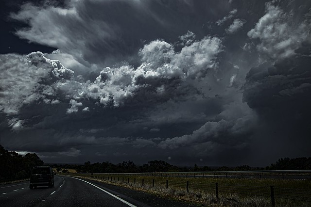
Interesting day of different damps.. WS wipers at all speeds.
Leaving FTG through the damp mist to hit Yea with a pleasant surprize,
As we pass Bonnie Doon toward Mansfield was very happy the rain didn’t freeze prior to hitting windscreen,
Massive drops… rivers on side of the road, turned the corner onto dirt road with a dust trail behind..
I missed the better shots being busy, thunder lightening and still no rain on site..
.
- Attachments
-
- IMG_7239.jpeg (1.19 MiB) Viewed 923 times
-
- IMG_7241.jpeg (3.12 MiB) Viewed 923 times
- jimmyay
- Cumulonimbus
- Reactions:
- Posts: 163
- Joined: Thu Dec 13, 2012 2:33 pm
- Location: Port Melbourne
Re: Becoming humid with showers, storms and rain: November 22-30
When’s the sun going to come out?!
Can’t remember an almost sunless week like this in Melbourne for a year or two.
Can’t remember an almost sunless week like this in Melbourne for a year or two.
- Gordon
- Supercell
- Reactions:
- Posts: 2896
- Joined: Thu Jun 17, 2010 10:01 am
- Location: Near Gordon, Vic. 620 m asl
Re: Becoming humid with showers, storms and rain: November 22-30
8 proper rain days in a row here - a first for 2023 at least.
Btw, might be time for a new thread? At least a bit of significant weather showing up towards the end of the week after a mild/warm break of a few days. And then the possibility of another big system for rain and cold, although too far out to lock in yet.
- stevco123
- Supercell
- Reactions:
- Posts: 2937
- Joined: Sat Aug 07, 2010 7:42 pm
- Location: Cranbourne 78m asl
Re: Becoming humid with showers, storms and rain: November 22-30
Week? Feels like the majority of the year has been cloudy. I guess that's the reason why Melbourne is Australia's least sunny capital
https://www.weatherlink.com/bulletin/53 ... 76dd68e8bc: for current weather updated every 2 minutes
-
Didjman

- Supercell
- Reactions:
- Posts: 2100
- Joined: Fri Sep 03, 2010 2:52 pm
- Location: Wallan, Vic 328m ASL
- Contact:
Re: Becoming humid with showers, storms and rain: November 22-30
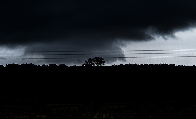
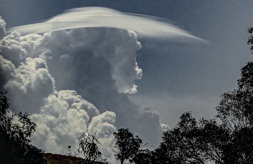
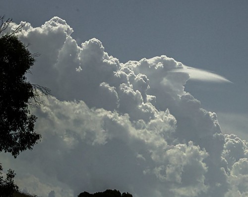
We finished with 54mm for the week - not a bad drop for here. Last Saturday, I went storm chasing with a mate up the Hume to Albury from Wallan to chase that massive line that formed. Got some good shots including a wallcloud west of Barnawartha:


- WeatherViewer
- Cumulonimbus
- Reactions:
- Posts: 389
- Joined: Fri Oct 19, 2012 5:57 pm
- Location: Truganina
Re: Becoming humid with showers, storms and rain: November 22-30
Picked up another 10.5 mm overnight.
If anyone is vaguely familiar with the western plains on the fringe of Melbourne's west. I'm over in Truganina about 22 km directly west of the CBD.
It's usually the arid drylands here, my amateur gauge has already recorded 43.38 mm for the month. Must have been in a sweet spot over the last few days.
- snowfall
- Supercell
- Reactions:
- Posts: 1292
- Joined: Mon Mar 20, 2017 7:39 pm
- Location: Gisborne South (349m asl)
Re: Becoming humid with showers, storms and rain: November 22-30
Impressive photos didjman.
54mm over the last 24 hours here. That gives us a very welcome 61mm start to the month and 130mm over the past 10 days. It was pretty much rain, drizzle and fog all day yesterday and into the night. It's currently cloudy and the rain has cleared. Everything now starts to shift gears towards a hot northerly tomorrow. Expecting it to get steamy tomorrow as all this water begins evaporating.
54mm over the last 24 hours here. That gives us a very welcome 61mm start to the month and 130mm over the past 10 days. It was pretty much rain, drizzle and fog all day yesterday and into the night. It's currently cloudy and the rain has cleared. Everything now starts to shift gears towards a hot northerly tomorrow. Expecting it to get steamy tomorrow as all this water begins evaporating.