Welcome New Members! We want to hear from you. Register, stop lurking and start posting!
VIC severe storms: Sept 28 2011
- Hamlan
- Storm Chaser
- Reactions:
- Posts: 449
- Joined: Tue Dec 22, 2009 11:05 pm
- Location: Northern suburbs
VIC severe storms: Sept 28 2011
Just got back from my first serious storm chase of the year with John which was a success. We intercepted 3 supercells in the Kerang region and they did not disappoint. Got up close to the wallclouds on 2 training supercells near Lake Boga. Was great to see the forcast conditions play out although wouldve been nice if the cells cycled more, but it is early in the season. CG fest, severe hail, extreme microburst and 3 decent RFD punches all added to the fun.
Brad.
Brad.
- Rivergirl
- Memorial
- Reactions:
- Posts: 3674
- Joined: Sun Nov 22, 2009 6:04 pm
- Location: Ferny Creek VIC
- Contact:
Re: VIC severe storms: Sept 28 2011
Look forward to your pics Brad 
- rikjpool
- Storm Chaser
- Reactions:
- Posts: 989
- Joined: Thu Nov 26, 2009 1:46 pm
- Location: Home: North Bendigo-just behind Lake Weeroona, Vic. Work: 1.5Km SE from Bendigo AWS
Re: VIC severe storms: Sept 28 2011
Will be very interested to see these. As I was on the same cells, 20km southeast and saw nothing pointing to Supercell status at all....
I live in a world where I dont see to believe, but I believe to see...
- Hamlan
- Storm Chaser
- Reactions:
- Posts: 449
- Joined: Tue Dec 22, 2009 11:05 pm
- Location: Northern suburbs
Re: VIC severe storms: Sept 28 2011
You assume we took pics.....of course we did. Im not surprised you didnt see anything if you were 20km away. Visibility was poor over distance, bases were very low, wall clouds in particular, and heavy precip was being taken downstream in your direction if you were SE. The speed shear on these cells with height (when we caught a glimpse of the updrafts) was impressive. With poor visibility we used radar and good road choices to get in close.rikjpool » Wed Sep 28, 2011 11:41 pm wrote:rikjpool wrote:Will be very interested to see these. As I was on the same cells, 20km southeast and saw nothing pointing to Supercell status at all....
- AUS_Twisted
- Storm Chaser
- Reactions:
- Posts: 652
- Joined: Wed Nov 25, 2009 6:15 pm
- Location: Dandenong North, Melb
Re: VIC severe storms: Sept 28 2011
I believe I drove through one of those cells you guys were on but further SE and by that time it just was a heap of lightning and heavy rain, ended up going north of Echuca after that getting ahead of the line from the West for awhile. My day started of crap before I even left as the night before I dropped my 17-85mm lens which has moved some of the elements out of place or something as it's taking blurry shots but everything is working fine and no glass is broken, I had no other wide lens to use so I ended up buying a Sigma 10-20 in the morning which cost me about 3 hours time (and the run through the city to go north was terrible, 1 accident with fire brigade and a broken down car blocking a lane on western ring road 
My highlight was driving through several cores, getting sideways through a round about when I didn't even try (was like ice) and seeing random CG's all over the place, some were very close (1 sounds like a shotgun with the crappy webcam mic) Yesterday reminded me of some of the big U.S days this year with lots of haze, low cloud and rain all over the place
Looking forward to your pics Brad.
- crikey
- Supercell
- Reactions:
- Posts: 1314
- Joined: Mon Feb 07, 2011 8:02 pm
- Location: tweed shire NSW and nDUNOLLY.. Nth Central district VIC
- Contact:
Re: VIC severe storms: Sept 28 2011
Just for the records
Radio Bendigo reported ... Melbourne had the highest September rainfall since l believe 1950's.
I hope the BOM write this storm up in their extreme events section.
In Dunolly , our final recording for rainfall for the 28th was 68mm.That amounts to over our mean monthly average for september.
Melbourne airport did not have the highest rainfall in the state. Reckon loddon shire did the best.
Barom around 998hPascals for much of that day.An Intensifying low, slow moving
Here is the synoptic during the most intense time of this event.

Low pressure cell Isobars extending well north into NSW/Quensland border.
Apparently there was a moisture infeed from the pacific ocean from the NEast.
I didn't see any cloud in feed like we normally see for the North west infeeds
Can anyone explain how you can view these infeeds from the pacific.What charts to you view? Couldn't find anything?
Great to see we can get such fabulous totals without the N/west infeed from WA
THe AGE 29th FEB page 3 sums up the impact in Melbourne
Within hours the central city received 42mm..more than 2/3rds the monthly average for September
Melbourne airport flights delayed from 4pm to 7pm
3 house in Melbourne hit by lightning
In Ballarat the horse races were abandoned after 4pm
Royal Melbourne show closed early
Power blackouts up to a total of 35,000 homes
SES went out to 270 calls for assistance ( fallen trees and flash flooding)
Strange that in Loddon shire we had no wind during the storm, we were probably in the centre of the low.
Get this!!
Melbourne water said they had to release sewage into Merri creek and Moonee ponds creek to prevent sewage backing up into household drains
Tried to get some snaps of radar and sat pic but didn't come off..
Radio Bendigo reported ... Melbourne had the highest September rainfall since l believe 1950's.
I hope the BOM write this storm up in their extreme events section.
In Dunolly , our final recording for rainfall for the 28th was 68mm.That amounts to over our mean monthly average for september.
Melbourne airport did not have the highest rainfall in the state. Reckon loddon shire did the best.
Barom around 998hPascals for much of that day.An Intensifying low, slow moving
Here is the synoptic during the most intense time of this event.

Low pressure cell Isobars extending well north into NSW/Quensland border.
Apparently there was a moisture infeed from the pacific ocean from the NEast.
I didn't see any cloud in feed like we normally see for the North west infeeds
Can anyone explain how you can view these infeeds from the pacific.What charts to you view? Couldn't find anything?
Great to see we can get such fabulous totals without the N/west infeed from WA
THe AGE 29th FEB page 3 sums up the impact in Melbourne
Within hours the central city received 42mm..more than 2/3rds the monthly average for September
Melbourne airport flights delayed from 4pm to 7pm
3 house in Melbourne hit by lightning
In Ballarat the horse races were abandoned after 4pm
Royal Melbourne show closed early
Power blackouts up to a total of 35,000 homes
SES went out to 270 calls for assistance ( fallen trees and flash flooding)
Strange that in Loddon shire we had no wind during the storm, we were probably in the centre of the low.
Get this!!
Melbourne water said they had to release sewage into Merri creek and Moonee ponds creek to prevent sewage backing up into household drains
Tried to get some snaps of radar and sat pic but didn't come off..
- apocalypse
- Cumulonumbus Calvas
- Reactions:
- Posts: 761
- Joined: Tue Jan 19, 2010 6:17 pm
- Location: Wagga Wagga, NSW 189m asl
Re: VIC severe storms: Sept 28 2011
Thought I go for a small chase today, wasn't expecting to see much either, but better than being bored at home. 
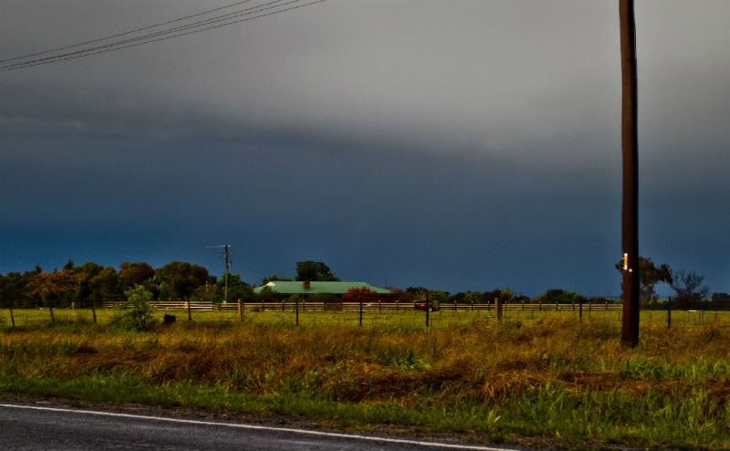
I drove north to a storm passing Junee which didn't look too exciting, and as I got closer I noticed something coming down from the sky, which turns out to be a faint (a very faint I might add!) landspout. Hope you can see it!


I drove north to a storm passing Junee which didn't look too exciting, and as I got closer I noticed something coming down from the sky, which turns out to be a faint (a very faint I might add!) landspout. Hope you can see it!


Nathan Morris
2013 Rainfall
Jan - 3.8mm
Feb - 27.0mm
Mar - 0.0mm
YTD - 30.8mm
2013 Rainfall
Jan - 3.8mm
Feb - 27.0mm
Mar - 0.0mm
YTD - 30.8mm
- flatcam
- Cumulonimbus
- Reactions:
- Posts: 182
- Joined: Wed Jan 05, 2011 8:16 pm
- Location: Craigieburn, Victoria
Re: VIC severe storms: Sept 28 2011
Great photo apocalypse!
Here's a pano I managed to take quickly yesterday. This is taken from the very edge of the rainshaft belonging to the main cell (I believe?) that went into melbourne around 4-4:30. I was caught in the core at Airport West and it was really intense! Huge CG's flashed all over the place and the power in the shopping center flickered once or twice. Was great to watch it roll through!

The size of the image has been reduced though to minimise download
Cheers, Cam
Edit: Unfotunately the edge has been cut off when I put it into the thread. Does any one know how to fix this?
Here's a pano I managed to take quickly yesterday. This is taken from the very edge of the rainshaft belonging to the main cell (I believe?) that went into melbourne around 4-4:30. I was caught in the core at Airport West and it was really intense! Huge CG's flashed all over the place and the power in the shopping center flickered once or twice. Was great to watch it roll through!

The size of the image has been reduced though to minimise download
Cheers, Cam
Edit: Unfotunately the edge has been cut off when I put it into the thread. Does any one know how to fix this?
- AUS_Twisted
- Storm Chaser
- Reactions:
- Posts: 652
- Joined: Wed Nov 25, 2009 6:15 pm
- Location: Dandenong North, Melb
Re: VIC severe storms: Sept 28 2011
Here's my round about highlight I mentioned above from yesterday, not sure if it will load for everyone as it's on Facebook
" onclick="window.open(this.href);return false;
" onclick="window.open(this.href);return false;
- AUS_Twisted
- Storm Chaser
- Reactions:
- Posts: 652
- Joined: Wed Nov 25, 2009 6:15 pm
- Location: Dandenong North, Melb
Re: VIC severe storms: Sept 28 2011
Here's some lightning shots from N Echuca on Wednesday at 20mm (currently don't have a lens between 20 - 70mm since Tuesday night  ), missed some really close CG's 15 mins further south that would of filled the frame, but the rain was bloody annoying and the whole line of embedded storms was moving pretty quick.


Re: VIC severe storms: Sept 28 2011
Nice, Steve. How'd you manage to catch those during the day?
Almost looks like a distant shelf cloud in the 2nd pic.
Almost looks like a distant shelf cloud in the 2nd pic.
- AUS_Twisted
- Storm Chaser
- Reactions:
- Posts: 652
- Joined: Wed Nov 25, 2009 6:15 pm
- Location: Dandenong North, Melb
Re: VIC severe storms: Sept 28 2011
Thanks Meso, was using f29 and continuous shooting mode to get the shots. Kinda annoyed about missing the earlier ones as they were close, had a CG south of me that was probably 200 meters away and the rain started to get heavier... thats when I went further up the road to get in front of the line and get these shots (even in that last shot it started to rain)
- daviescr
- Supercell
- Reactions:
- Posts: 1394
- Joined: Wed Dec 02, 2009 5:40 pm
- Location: Warranwood, Vic
Re: VIC severe storms: Sept 28 2011
Lovely pics Steve, very moody! Just catching up on all the action, stunned at the 500+ posts while I was up in Sydney this week... This is why I love this forum, great for living vicariously through you guys..
- Hamlan
- Storm Chaser
- Reactions:
- Posts: 449
- Joined: Tue Dec 22, 2009 11:05 pm
- Location: Northern suburbs
Re: VIC severe storms: Sept 28 2011
Pics from Wednesday's storm chase in the Lake Boga, Kerang, Barham region. 3 are massive wide angle stiched pano's (up to 12 wide angle shots stitched) which distort the storm structure somewhat and make the storm look much further away than it was (it was very close with the large inflow band over our heads). Shame about the rain drops on the lens in the pano's but I think they look great anyway!


Handheld and wide angle during an extraordinary CG fest near Lake Boga! taken at 3.47pm - 1/50th shutter, f5.6, ISO160

The shear-induced updraft tilt to the SE was really impressive and kept the resulting precip a long way downstream from the updraft base.


Handheld and wide angle during an extraordinary CG fest near Lake Boga! taken at 3.47pm - 1/50th shutter, f5.6, ISO160

The shear-induced updraft tilt to the SE was really impressive and kept the resulting precip a long way downstream from the updraft base.


Re: VIC severe storms: Sept 28 2011
Nice shots. Some interesting lowering's from a wannabe wall cloud...
Well done on getting some photos of the storm structure....looking at radrar it looked like nothing but a cloudy mess, so well done on getting some sort of photos of the structure. No one else did.
Well done on getting some photos of the storm structure....looking at radrar it looked like nothing but a cloudy mess, so well done on getting some sort of photos of the structure. No one else did.
Last edited by Meso on Sun Oct 02, 2011 12:41 pm, edited 1 time in total.
- Hamlan
- Storm Chaser
- Reactions:
- Posts: 449
- Joined: Tue Dec 22, 2009 11:05 pm
- Location: Northern suburbs
Re: VIC severe storms: Sept 28 2011
Hi Greg, I assume you refer to the last images re the wannabe wallcloud. Yeah it was interesting. The storm had transitioned to HP previously and was outflow dominant near Barham but an area briefly tried to organise as seen in the pics.
Not sure what you mean that it wasnt memorable though. We were quite happy with the cells we got. As I said in my posts, the storms didnt disappoint, especially for early season. The effect of shear (as predicted in the forcast soundings) was on display and was really cool, bases were low, rotation was evident in several of the storms with beautiful inflow features and mid-level banding on one in particular, updrafts were nice when we could see them (from the northern side), CG's were incredible and frequent, the RFD we got nailed by was intense with horizontal rain smashing hail over 2cm into the side windows and causing complete white out. The only down side was the cells didnt exhibit these features for long enough for our liking and turned into the mess you guys saw further south. Not sure what time you looked at radar but we were very interested in the prefrontal cells as they came down from the NE and got into position early. Dont forget these cells were on the edge of Mildura radar and despite attenuation were showing storm splitting and then very strong cores when we intercepted. Havent checked radar since but im pretty sure our storms were prefrontal but could be wrong.
Not sure what you mean that it wasnt memorable though. We were quite happy with the cells we got. As I said in my posts, the storms didnt disappoint, especially for early season. The effect of shear (as predicted in the forcast soundings) was on display and was really cool, bases were low, rotation was evident in several of the storms with beautiful inflow features and mid-level banding on one in particular, updrafts were nice when we could see them (from the northern side), CG's were incredible and frequent, the RFD we got nailed by was intense with horizontal rain smashing hail over 2cm into the side windows and causing complete white out. The only down side was the cells didnt exhibit these features for long enough for our liking and turned into the mess you guys saw further south. Not sure what time you looked at radar but we were very interested in the prefrontal cells as they came down from the NE and got into position early. Dont forget these cells were on the edge of Mildura radar and despite attenuation were showing storm splitting and then very strong cores when we intercepted. Havent checked radar since but im pretty sure our storms were prefrontal but could be wrong.
Last edited by Hamlan on Sun Oct 02, 2011 7:48 pm, edited 1 time in total.
Re: VIC severe storms: Sept 28 2011
Neither am I. Just ignore me...posted after way too many grand final drinks.Hamlan » Sun Oct 02, 2011 11:22 am wrote:Hamlan wrote:Not sure what you mean that it wasnt memorable though.
Pics suggest it was actually quite a memorable chase for you guys. Well done.
- AUS_Twisted
- Storm Chaser
- Reactions:
- Posts: 652
- Joined: Wed Nov 25, 2009 6:15 pm
- Location: Dandenong North, Melb
Re: VIC severe storms: Sept 28 2011
Yeah I believe they were prefrontal, I was checking the radar a fair bit on the road and there was some nice looking cells NW (I went after one of the heavier cells that stood out by itself on radar when it was more SE, but was a mess by then) I wanted to be around the NNW border around 11 AM but had to buy a lens in the morning, far to much time lost there.Hamlan » Sun Oct 02, 2011 11:22 am wrote:Hamlan wrote: The only down side was the cells didnt exhibit these features for long enough for our liking and turned into the mess you guys saw further south. Not sure what time you looked at radar but we were very interested in the prefrontal cells as they came down from the NE and got into position early. Dont forget these cells were on the edge of Mildura radar and despite attenuation were showing storm splitting and then very strong cores when we intercepted. Havent checked radar since but im pretty sure our storms were prefrontal but could be wrong.
Def wasn't a great day for photography, I'd like to see some more clear air stuff without all that crap haze and low cloud coming in from the NE
Nice pics though brad, you guys did good
- Twister
- Cumulonumbus Calvas
- Reactions:
- Posts: 914
- Joined: Sun Nov 29, 2009 10:47 pm
- Location: Brisbane Qld
Re: VIC severe storms: Sept 28 2011
Yeah good pics nice to see some structure, we got these cells once they formed the squall and it was pretty impressive squall at that.
You get any pics of the hail would be interested to see that if you did
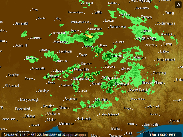
Also really check out the Mildura radar all the splitting super cells that day on radar were very impressive.
Great stuff
Hopefully we get another go this weekend
You get any pics of the hail would be interested to see that if you did
Also really check out the Mildura radar all the splitting super cells that day on radar were very impressive.
Great stuff
Hopefully we get another go this weekend
Now Living in Wet QLD
- Hamlan
- Storm Chaser
- Reactions:
- Posts: 449
- Joined: Tue Dec 22, 2009 11:05 pm
- Location: Northern suburbs
Re: VIC severe storms: Sept 28 2011
haha that made me laugh.Meso wrote:Neither am I. Just ignore me...posted after way too many grand final drinks.Hamlan » Sun Oct 02, 2011 11:22 am wrote:Hamlan wrote:Not sure what you mean that it wasnt memorable though.