17 people killed in severe hail storms .In populated industrial area.. April 2011
http://www.weatherzone.com.au/news/17-k ... torm/17142" onclick="window.open(this.href);return false;

Welcome New Members! We want to hear from you. Register, stop lurking and start posting!
CHINA: significant weather events 2011
-
crikey

- Supercell
- Reactions:
- Posts: 1314
- Joined: Mon Feb 07, 2011 8:02 pm
- Location: tweed shire NSW and nDUNOLLY.. Nth Central district VIC
- Contact:
Re: CHINA: significant weather events 2011
Breaking news
Rains in China leave 70 dead or missing
# AAP
# July 08, 2011 11:02PM
http://www.news.com.au/breaking-news/ra ... 6091059563" onclick="window.open(this.href);return false;
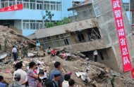
STATE media say heavy rains across China have left at least 70 people dead or missing over the past week.
Xinhua News Agency reported today that 49 people died from July 1 through Friday in rain-triggered disasters. At least 21 people disappeared during the heavy rains in Shanxi, Sichuan, and Hebei provinces.
Seasonal flooding last month left more than 260 people dead or missing in eastern and southern China.
The flooding in those areas has triggered landslides, forced the evacuation of thousands and caused nearly $1 billion in direct economic losses.
Read more: http://www.news.com.au/breaking-news/ra ... z1RWH8CSiN" onclick="window.open(this.href);return false;
Rains in China leave 70 dead or missing
# AAP
# July 08, 2011 11:02PM
http://www.news.com.au/breaking-news/ra ... 6091059563" onclick="window.open(this.href);return false;
STATE media say heavy rains across China have left at least 70 people dead or missing over the past week.
Xinhua News Agency reported today that 49 people died from July 1 through Friday in rain-triggered disasters. At least 21 people disappeared during the heavy rains in Shanxi, Sichuan, and Hebei provinces.
Seasonal flooding last month left more than 260 people dead or missing in eastern and southern China.
The flooding in those areas has triggered landslides, forced the evacuation of thousands and caused nearly $1 billion in direct economic losses.
Read more: http://www.news.com.au/breaking-news/ra ... z1RWH8CSiN" onclick="window.open(this.href);return false;
-
crikey
- Supercell
- Reactions:
- Posts: 1314
- Joined: Mon Feb 07, 2011 8:02 pm
- Location: tweed shire NSW and nDUNOLLY.. Nth Central district VIC
- Contact:
Re: CHINA: significant weather events 2011
Extract
More than 460 people have died or gone missing in China since June 2011, after extreme summer weather triggered huge floods and deadly landslides, government authorities said.
http://news.yahoo.com/china-landslides- ... 40545.html" onclick="window.open(this.href);return false;
More than 460 people have died or gone missing in China since June 2011, after extreme summer weather triggered huge floods and deadly landslides, government authorities said.
http://news.yahoo.com/china-landslides- ... 40545.html" onclick="window.open(this.href);return false;
-
crikey
- Supercell
- Reactions:
- Posts: 1314
- Joined: Mon Feb 07, 2011 8:02 pm
- Location: tweed shire NSW and nDUNOLLY.. Nth Central district VIC
- Contact:
Re: CHINA: significant weather events 2011
There is the possibility that tropical storm TS 17W ( KULUP)could develop into a typhoon that could approach Taiwan and the capital of China Taipei.
It is certainly looking the part on the sat pic tonight

One of the interesting things about following world weather is that you have to learn some geography on the way. LOL
Taipei City (Chinese: 臺北市; pinyin: Táiběi Shì)[1] is the capital of the Republic of China (ROC, commonly known as "Taiwan") and the central city of the largest metropolitan area of Taiwan. Situated at the northern tip of the island,
Due to Taiwan's location in the Pacific Ocean, it is affected by the Pacific typhoon season, which occurs between June and October.
http://en.wikipedia.org/wiki/Taipei" onclick="window.open(this.href);return false;
Could you imagine a cyclone forecast to come close to Canberra parliament. LOL
Here is the current track from
http://www.usno.navy.mil/JTWC/" onclick="window.open(this.href);return false;

070900Z POSITION NEAR 22.1N 135.7E.
TROPICAL STORM (TS) 17W (KULAP), LOCATED APPROXIMATELY 510 NM EAST-
SOUTHEAST OF KADENA AIR BASE, JAPAN, HAS TRACKED NORTHWARD AT 05
KNOTS OVER THE PAST SIX HOURS. ANIMATED MULTISPECTRAL IMAGERY SHOWS
A SMALL, DENSE, AND TIGHTLY ORGANIZED SYSTEM UNDERGOING RAPID
DEVELOPMENT.
..
DUE TO THE SMALL
SIZE AND RAPID DEVELOPMENT OF TS 17W, MODEL GUIDANCE HAS NOT CAUGHT
UP WITH THE SYSTEM YET.
It is certainly looking the part on the sat pic tonight
One of the interesting things about following world weather is that you have to learn some geography on the way. LOL
Taipei City (Chinese: 臺北市; pinyin: Táiběi Shì)[1] is the capital of the Republic of China (ROC, commonly known as "Taiwan") and the central city of the largest metropolitan area of Taiwan. Situated at the northern tip of the island,
Due to Taiwan's location in the Pacific Ocean, it is affected by the Pacific typhoon season, which occurs between June and October.
http://en.wikipedia.org/wiki/Taipei" onclick="window.open(this.href);return false;
Could you imagine a cyclone forecast to come close to Canberra parliament. LOL
Here is the current track from
http://www.usno.navy.mil/JTWC/" onclick="window.open(this.href);return false;
070900Z POSITION NEAR 22.1N 135.7E.
TROPICAL STORM (TS) 17W (KULAP), LOCATED APPROXIMATELY 510 NM EAST-
SOUTHEAST OF KADENA AIR BASE, JAPAN, HAS TRACKED NORTHWARD AT 05
KNOTS OVER THE PAST SIX HOURS. ANIMATED MULTISPECTRAL IMAGERY SHOWS
A SMALL, DENSE, AND TIGHTLY ORGANIZED SYSTEM UNDERGOING RAPID
DEVELOPMENT.
..
DUE TO THE SMALL
SIZE AND RAPID DEVELOPMENT OF TS 17W, MODEL GUIDANCE HAS NOT CAUGHT
UP WITH THE SYSTEM YET.