
Welcome New Members! We want to hear from you. Register, stop lurking and start posting!
Victoria: Major upper and surface lows - 12–16 Dec 2018
- JasmineStorm
- Supercell
- Reactions:
- Posts: 1870
- Joined: Thu Sep 22, 2016 9:40 pm
- Location: Kyneton 527 ASL
Re: Major upper and surface lows 12–16 Dec
Multicell clusters closing in from the west , NW. The great southern upper low pressure is closing in on S.A. Interacting jet streams are now going to support storm development in the next 36 hours. Looks like High Precip super-cells are kicking off near the S.A border heading for the Wimmera.
- wolfcat
- Cumulonumbus Calvas
- Reactions:
- Posts: 562
- Joined: Sun Mar 07, 2010 12:14 pm
- Location: Bentleigh East
- Contact:
Re: Major upper and surface lows 12–16 Dec
Building nicely and heading our way.
other places you will find me...
My blog...http://www.wolfcat.com.au/randomrants/
Flickr .. http://www.flickr.com/photos/wolfcat_aus/
Twitter... http://twitter.com/wolfcat
Redbubble... http://www.redbubble.com/people/wolfcat
My blog...http://www.wolfcat.com.au/randomrants/
Flickr .. http://www.flickr.com/photos/wolfcat_aus/
Twitter... http://twitter.com/wolfcat
Redbubble... http://www.redbubble.com/people/wolfcat
- Wilko
- Supercell
- Reactions:
- Posts: 1492
- Joined: Wed Aug 11, 2010 12:08 pm
- Location: Moorabbin & Highett, Vic
Re: Major upper and surface lows 12–16 Dec
Hey team
Why do the BOM say just "30% shower or 2"in 'Melbourne tonight ?
Can we expect the rain and storms out west to dissipate ?
That does not line up ?
Partly cloudy. Slight (30%) chance of a shower, becoming less likely later this evening. The chance of a thunderstorm. Winds northerly 15 to 20 km/h turning east to northeasterly in the evening.
-
Didjman

- Supercell
- Reactions:
- Posts: 2100
- Joined: Fri Sep 03, 2010 2:52 pm
- Location: Wallan, Vic 328m ASL
- Contact:
Re: Major upper and surface lows 12–16 Dec
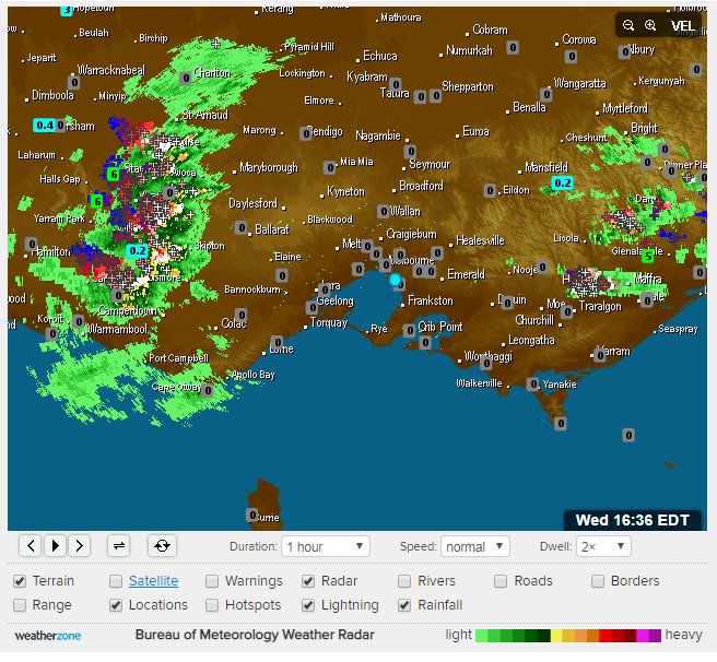
Wow at radar!!
- Gordon
- Supercell
- Reactions:
- Posts: 2896
- Joined: Thu Jun 17, 2010 10:01 am
- Location: Near Gordon, Vic. 620 m asl
Re: Major upper and surface lows 12–16 Dec
Well I don't think it's going to miss Ballarat, where I'm about to head for the next few hours...
- Dane
- Supercell
- Reactions:
- Posts: 1661
- Joined: Thu Nov 26, 2009 9:51 am
- Location: Sebastopol 420m ASL
- Contact:
Re: Major upper and surface lows 12–16 Dec
Wilko said Hey team
Why do the BOM say just "30% shower or 2"in 'Melbourne tonight ?
Can we expect the rain and storms out west to dissipate ?
That does not line up ?
Was wondering that myself, seems to be becoming more developed and heading this way.
Why do the BOM say just "30% shower or 2"in 'Melbourne tonight ?
Can we expect the rain and storms out west to dissipate ?
That does not line up ?
Was wondering that myself, seems to be becoming more developed and heading this way.
Re: Major upper and surface lows 12–16 Dec
no severe storm warning either...
-
Didjman
- Supercell
- Reactions:
- Posts: 2100
- Joined: Fri Sep 03, 2010 2:52 pm
- Location: Wallan, Vic 328m ASL
- Contact:
Re: Major upper and surface lows 12–16 Dec
Alot of radio static so that band near Ballarat must have a lot of CCs
- JasmineStorm
- Supercell
- Reactions:
- Posts: 1870
- Joined: Thu Sep 22, 2016 9:40 pm
- Location: Kyneton 527 ASL
Re: Major upper and surface lows 12–16 Dec
I can't speak for the BoM but I'd say the BoM's forecast is factoring in the decaying of the initial wave of storms due to surface cooling. Latest EC doesn't even have the line of clusters, so models are struggling  Only mother nature really knows but I'm sticking with my original thunderstorm alley watch from 2pm to 9pm that includes Melbourne
The storms moving into the Mallee, Wimmera and NSW will be super charged from the jet streams. BoM have a STW on those.
The storms moving into the Mallee, Wimmera and NSW will be super charged from the jet streams. BoM have a STW on those.
-
Australis(Shell3155)

- Supercell
- Reactions:
- Posts: 3147
- Joined: Mon Nov 30, 2009 8:05 pm
- Location: FTG
- Contact:
Re: Major upper and surface lows 12–16 Dec
Horsham needs the water for drinking..
how much longer can i leave my washing on the line...
how much longer can i leave my washing on the line...
- Wilko
- Supercell
- Reactions:
- Posts: 1492
- Joined: Wed Aug 11, 2010 12:08 pm
- Location: Moorabbin & Highett, Vic
Re: Major upper and surface lows 12–16 Dec
Thanks JasmineJasmineStorm wrote: ↑Wed Dec 12, 2018 5:52 pm I can't speak for the BoM but I'd say the BoM's forecast is factoring in the decaying of the initial wave of storms due to surface cooling. Latest EC doesn't even have the line of clusters, so models are struggling
The storms moving into the Mallee, Wimmera and NSW will be super charged from the jet streams. BoM have a STW on those.
Well Dane if this is a portent of things to come then maybe just maybe the BOM are underscoring this event !
I know they have been gun-shy since they were pounded by media but fair dinkum
This is the last I will say on the subject as I hate point scoring and there is more than enough to blog about . this weather
is much more interesting !
The BOM do a good enough Job
-
hillybilly

- Site Admin/Moderator
- Reactions:
- Posts: 5006
- Joined: Thu Nov 26, 2009 7:26 am
- Location: Howden Tasmania, 25m above sea level
- Contact:
Re: Major upper and surface lows 12–16 Dec
Models really struggle with convection at short time range. They don't currently assimilate convection nor predict it explicitly in the global models because it sits below the model grid cells (you need to get your model down to 2-5km to capture convection explicitly, and current models are typically in the 10-20km range). It's quite common that they will fail to pick convective showers at short range, or produce spurious convective showers. They do well when the showers/storms are part of a larger synoptic system, but less good when they are pulse "self organising" storms.JasmineStorm wrote: ↑Wed Dec 12, 2018 5:52 pm I can't speak for the BoM but I'd say the BoM's forecast is factoring in the decaying of the initial wave of storms due to surface cooling. Latest EC doesn't even have the line of clusters, so models are struggling
The storms moving into the Mallee, Wimmera and NSW will be super charged from the jet streams. BoM have a STW on those.
It appears to me that the band out west has largely self organised and has established a favourable converging wind-field. You would tend to think this will fade as the solar heating drops, but there is still a few hours of sunshine left.
The main developing rain events is still further west.
Stinker of a day in Ferny Creek. 29C with mid to high teens DP. More like Darwin than the Dandenongs (speaking of Darwin, last night they had their hottest night on record with a 30.0C
- JasmineStorm
- Supercell
- Reactions:
- Posts: 1870
- Joined: Thu Sep 22, 2016 9:40 pm
- Location: Kyneton 527 ASL
Re: Major upper and surface lows 12–16 Dec
Yep, agree.hillybilly wrote: ↑Wed Dec 12, 2018 6:04 pm
Models really struggle with convection at short time range. They don't currently assimilate convection nor predict it explicitly in the global models because it sits below the model grid cells (you need to get your model down to 2-5km to capture convection explicitly, and current models are typically in the 10-20km range).
Rumbles to the west. That cell near Geelong is getting juicy. It's all very slow moving, the nearer it gets to sunset the more chance it can decay IMO.
- JasmineStorm
- Supercell
- Reactions:
- Posts: 1870
- Joined: Thu Sep 22, 2016 9:40 pm
- Location: Kyneton 527 ASL
Re: Major upper and surface lows 12–16 Dec
Winds at 700 hPa near the dividing range are starting to steer the decaying clusters north /south but surface winds are converging between Melbourne and Geelong. This may kick off new cells....very hard to pick
edit: that wind convergence has just popped near the heads with a black core.
edit: that wind convergence has just popped near the heads with a black core.
- Luken
- Cumulus
- Reactions:
- Posts: 92
- Joined: Thu Nov 26, 2009 7:35 am
- Location: Belgrave South, 250m ASL
Re: Major upper and surface lows 12–16 Dec
BIG gusts through Mitcham just now out of nowhere. I'm putting kids to sleep right now so cant go check, but by the sound it came and has now died off.. odd
- Luken
- Cumulus
- Reactions:
- Posts: 92
- Joined: Thu Nov 26, 2009 7:35 am
- Location: Belgrave South, 250m ASL
Re: Major upper and surface lows 12–16 Dec
Dopplers says it all. SW change wonder what that does to rainfall tonight?
edit - I reckon we miss round one and round 2 up near the border will be the start of the main event.
edit - I reckon we miss round one and round 2 up near the border will be the start of the main event.
-
hillybilly
- Site Admin/Moderator
- Reactions:
- Posts: 5006
- Joined: Thu Nov 26, 2009 7:26 am
- Location: Howden Tasmania, 25m above sea level
- Contact:
Re: Major upper and surface lows 12–16 Dec
Wind change pushed through here with a line of decent Cu. Quite lumpy out there, so wouldn’t be at all surprised to see the odd shower or storm pop up.
The main event is back near the SA border. Radar coverage is not great there so a lot of rain not showing up so well ATM.
EC got 50-100mm for most parts of central Vic the next 36 hours, and good falls elsewhere
Edit> couple of cells just gone up on the southern end of the line.
The main event is back near the SA border. Radar coverage is not great there so a lot of rain not showing up so well ATM.
EC got 50-100mm for most parts of central Vic the next 36 hours, and good falls elsewhere
Edit> couple of cells just gone up on the southern end of the line.
-
Didjman
- Supercell
- Reactions:
- Posts: 2100
- Joined: Fri Sep 03, 2010 2:52 pm
- Location: Wallan, Vic 328m ASL
- Contact:
Re: Major upper and surface lows 12–16 Dec
The sky looks like a flang could come from anywhere!! Has that feel to it here
- snowfall
- Supercell
- Reactions:
- Posts: 1291
- Joined: Mon Mar 20, 2017 7:39 pm
- Location: Gisborne South (349m asl)
Re: Major upper and surface lows 12–16 Dec
Raining here with some heavy bursts and 17.6c. Showrs also moving into parts of the Melbourne area. Was really muggy today but great watching the sky build as the afternoon rolled on.
- HarleyB
- Cumulonumbus Calvas
- Reactions:
- Posts: 839
- Joined: Sun Oct 10, 2010 9:39 pm
- Location: Wangaratta
Re: Major upper and surface lows 12–16 Dec
Hopetoun up to 28mm already, fantastic start up there!