Page 1 of 8
Vic: Fronts and troughs 9 - 19 July
Posted: Mon Jul 08, 2019 3:59 pm
by JasmineStorm
2 fronts and multiple polar troughs will launch into Vic and Tassie from late Wednesday to Saturday. Highest rainfall totals will be regions that do well from west to south westerly flows. The most interesting feature will be how low snow will fall on Friday night into Saturday. Let the upgrades and downgrades begin

Edit: date range to bring in a 4th and 5th cold front
Re: Fronts and troughs 9 - 13 July
Posted: Mon Jul 08, 2019 4:10 pm
by crikey
An interesting week for VIC who will see the best of these fronts..
ACC r has the first of these fronts arriving in the SW of VIC on wednesday at 4pm.
A strong frontal band with a good precip' signal. I would not rule out embedded storms
The usual winds picking up becfre and after the front arrives
Link ro ACC r
http://www.bom.gov.au/australia/charts/ ... fresh+View
Re: Vic: Fronts and troughs 9 - 13 July
Posted: Mon Jul 08, 2019 11:51 pm
by Jake Smethurst
Thanks for starting this Jasmine!
Definitely looking interesting, Crikey! I'll be travelling home to see family near the 12 apostles on either Friday night or early Saturday, so should be cold and wet and windy down there! I wonder how muddy the farm is?
Looking a good event overall, especially for those parts who do well with the southwestrly fetch as JS says
Re: Vic: Fronts and troughs 9 - 13 July
Posted: Tue Jul 09, 2019 6:01 am
by hillybilly
Might want to extend those dates as EC now has this sequence going well into next week

Quite the frontal barrage. Will add up substantially in the usual wet spots, and spread decent falls elsewhere. Ten days total top 100mm in South Gippsland, Otways, and northeast on the EC, and locally approach 200mm. Just a model, and it will tend to underestimate topographical effects so won’t be exactly like that

Expecting 50-100mm here in FC, and probably 100mm plus at Walkerville. Lucky tides this coming week are low as this one will set up a large tidal surge and batter the coastline.
Big boost to the snow season after a very poor few weeks. Basically no natural snow at most the Vic resorts ATM

Re: Vic: Fronts and troughs 9 - 13 July
Posted: Tue Jul 09, 2019 6:45 am
by Didjman
On the Satpic loop, you can already see the SW conveyor belt heading up toward SW WA.
Re: Vic: Fronts and troughs 9 - 16 July
Posted: Tue Jul 09, 2019 11:04 am
by JasmineStorm
Just lengthening the date range to incorporate the 3rd front in the sequence early next week.
All models starting to lock onto the polar jet shaking hands with the subtropical jet over NSW on Friday. Around -33c @500 hPa over the mainland as the upper trough balloons in.
Re: Vic: Fronts and troughs 9 - 16 July
Posted: Tue Jul 09, 2019 2:25 pm
by crikey
Can l 'like' all those posts. !
The 100mm forecast exciting 'Didjman' Especially for the alps. There has been a boom and bust season there this year.
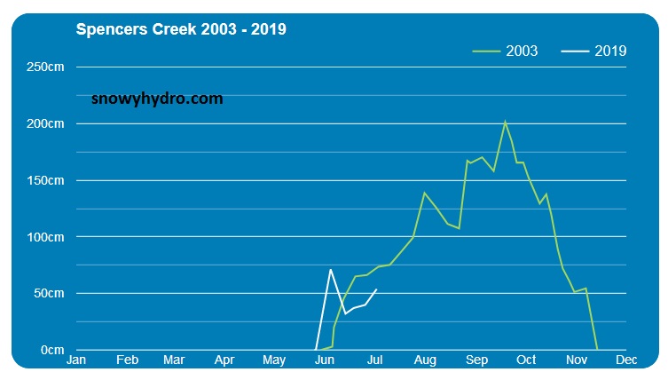
The spencer creek depth chart showing that nicely. If we have a metre of snow this next few weeks that spencer creek graph will even look more bizarre.
I haven't seen that on the time series before?
Re: Vic: Fronts and troughs 9 - 16 July
Posted: Tue Jul 09, 2019 2:38 pm
by StratoBendigo
crikey wrote: ↑Tue Jul 09, 2019 2:25 pm
Can l 'like' all those posts. !
The 100mm forecast exciting 'Didjman' Especially for the alps. There has been a boom and bust season there this year.
The spencer creek depth chart showing that nicely. If we have a metre of snow this next few weeks that spencer creek graph will even look more bizarre.
I haven't seen that on the time series before?
There have been other years with a good start, a lull until mid-July, and then good snow after that. i.e. 2003.
Anyway, I'm looking forward to some polar modified air
Re: Vic: Fronts and troughs 9 - 16 July
Posted: Tue Jul 09, 2019 4:12 pm
by Australis(Shell3155)
Torential downpour here this afternoon..
Re: Vic: Fronts and troughs 9 - 16 July
Posted: Tue Jul 09, 2019 4:46 pm
by crikey
StratoBendigo wrote: ↑Tue Jul 09, 2019 2:38 pm
crikey wrote: ↑Tue Jul 09, 2019 2:25 pm
Can l 'like' all those posts. !
The 100mm forecast exciting 'Didjman' Especially for the alps. There has been a boom and bust season there this year.
The spencer creek depth chart showing that nicely. If we have a metre of snow this next few weeks that spencer creek graph will even look more bizarre.
I haven't seen that on the time series before?
There have been other years with a good start, a lull until mid-July, and then good snow after that. i.e. 2003.
Anyway, I'm looking forward to some polar modified air
OK. I stand. corrected.Too early for comparisons. 'the night is yet young'
https://www.snowyhydro.com.au/our-energ ... alculator/
Re: Vic: Fronts and troughs 9 - 16 July
Posted: Tue Jul 09, 2019 5:54 pm
by hillybilly
Surprised to score 4mm in FC today. Showers were heavy and had a spring storm feel to them. MTD nearly up to 20mm so looking decidedly better than a couple of days back.
EC wiggled backwards on rain totals, but looks colder for the weekend. Is getting close to the numbers that usually see snow in the Dandenongs (perhaps a degree too warm ATM). Would like to see a bit more NW/SW variation in the sequence, as the current models do tend to be quite westerly which tends to give the best falls to the ranges and immediate coastal strip.
Re: Vic: Fronts and troughs 9 - 16 July
Posted: Tue Jul 09, 2019 11:41 pm
by Sean
Finally something a little exciting. It's felt like spring for over a week, especially when that sun was out.
Re: Vic: Fronts and troughs 9 - 16 July
Posted: Wed Jul 10, 2019 8:06 am
by Tassiedave
Tas rainfall since 9 am yesterday: Mt Read 35mm, Henty Canal 26mm, Waratah 16mm, Mt Barrow 13mm, Nunamara 11mm, Low Head 10mm, Launceston 6.8mm, Hobart 0mm
Re: Vic: Fronts and troughs 9 - 16 July
Posted: Wed Jul 10, 2019 11:40 am
by Didjman
Satpic looks impressive!!
Re: Vic: Fronts and troughs 9 - 16 July
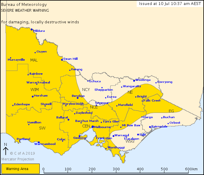
Posted: Wed Jul 10, 2019 11:59 am
by wolfcat
Updated Warning now includes Central
Re: Vic: Fronts and troughs 9 - 16 July
Posted: Wed Jul 10, 2019 4:25 pm
by Jake Smethurst
Warning well and truly warranted! Winds began picking up here this morning, but beginning to see sustained speeds 40-50km/h and gusts above 65 km/h. Few tree branches down around the place and even at work a few that we thought could become problematic (thankfully not).
Fairly blowy out at the airport as usual. Airport operations down to one runway which is resulting in delays as one would expect.
The showers in the southwest have seen some okay falls thus far, up to 13mm at Cape Nelson and and 12mm at Portland Airport.
Re: Vic: Fronts and troughs 9 - 16 July
Posted: Wed Jul 10, 2019 5:11 pm
by flyfisher
Don't often see a warm front mentioned in the forecast - I saw it on the BOM map so went looking at the Tasmanian summary...
Weather Situation
Strong and gusty northerly winds over Tasmania will shift westerly overnight as a cold front currently near the west crosses the state. Winds will ease briefly behind this front then freshen Thursday night as a warm front crosses the state, closely followed by a cold front early on Friday. A cooler westerly flow in the front's wake will then shift very cold southerly behind another cold front early Saturday. Yet another strong cold front is then expected on Sunday, as a deep low passing to the south brings a very strong southwesterly flow to the state.
Re: Vic: Fronts and troughs 9 - 16 July
Posted: Wed Jul 10, 2019 5:15 pm
by Didjman
There are some dark saturated bases on the SC going past here. Surprisingly the drive nth from Tulla wasn't as bad as expected (with gusts to 70klms).
Re: Vic: Fronts and troughs 9 - 16 July
Posted: Wed Jul 10, 2019 6:59 pm
by Didjman
At midnight, baro here was 1019.64. Now it is 1006.43. Not a bad drop!
Re: Vic: Fronts and troughs 9 - 16 July
Posted: Wed Jul 10, 2019 7:07 pm
by Adam38
The wind has hit with a bang here!! Very strong.