Another complex easterly system showing up with a long wave trough moving into the southeast for the start of the work week, with a deepening surface trough which eventually forms a close low east of Tasmania. System looks very wet for the western third of Tasmania, pretty decent for the centre and east. VIC looks more hit miss, but could be decent showers and even a rumble, more in the south. Starting to look like this system will not fully clear out the moisture, so might well have showers and storms reappear before Christmas.
Currently the combo of positive SAM and a weak monsoon is playing in our favour so we are getting upper troughs, and plenty of low level moisture.

Welcome New Members! We want to hear from you. Register, stop lurking and start posting!
Another trough in the easterlies forming a low: December 18-20
-
hillybilly

- Site Admin/Moderator
- Reactions:
- Posts: 4999
- Joined: Thu Nov 26, 2009 7:26 am
- Location: Howden Tasmania, 25m above sea level
- Contact:
- Gordon
- Supercell
- Reactions:
- Posts: 2895
- Joined: Thu Jun 17, 2010 10:01 am
- Location: Near Gordon, Vic. 620 m asl
Re: Another trough in the easterlies forming a low: December 18-20
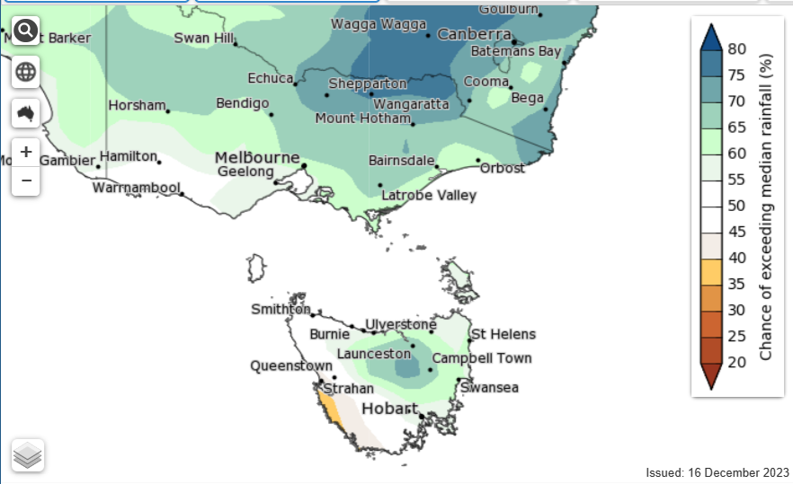
Latest climate update suggests above average rainfall for the Christmas period (map is for 21-27/12):
- Dane
- Supercell
- Reactions:
- Posts: 1661
- Joined: Thu Nov 26, 2009 9:51 am
- Location: Sebastopol 420m ASL
- Contact:
Re: Another trough in the easterlies forming a low: December 18-20
BOM not really excited by this system going for a total of 0 to 4mm up and including the 24th of December in Ballarat
0 to 5mm for Melbourne for The same dates.
0 to 5mm for Melbourne for The same dates.
-
hillybilly
- Site Admin/Moderator
- Reactions:
- Posts: 4999
- Joined: Thu Nov 26, 2009 7:26 am
- Location: Howden Tasmania, 25m above sea level
- Contact:
Re: Another trough in the easterlies forming a low: December 18-20
This system has been downgrading with each model run  Looks like 10mm here now, when some of the earlier runs has more than 50mm.
System peaks over southwest Tasmania then northeast Tasmania and Bass Strait. Theres the rainband today on the upper trough then a secondary low develop for later tomorrow.
Christmas Day looks a bit interesting. Some suggestions of a strong cold outbreak down here with a low forming. EC has had it cold enough for snow on the mountain. More marginal for VIC. We had a bit of graupel on the mountain on Saturday when I hiked across the top, but didn’t see any proper snow.
Btw crazy crazy system up in North Queensland. So many records broken. Bit hard to compare flood peaks since the landscape has changed and there are some new dams, but certainly an extraordinary event. Quite possible broken the highest 12 hour rainfall total for any time of year for any place in Queensland. Damage bill is going to be very bad. Flood insurance is getting very expensive or impossible to get, so be so much impact on people
 Looks like 10mm here now, when some of the earlier runs has more than 50mm.
System peaks over southwest Tasmania then northeast Tasmania and Bass Strait. Theres the rainband today on the upper trough then a secondary low develop for later tomorrow.
Christmas Day looks a bit interesting. Some suggestions of a strong cold outbreak down here with a low forming. EC has had it cold enough for snow on the mountain. More marginal for VIC. We had a bit of graupel on the mountain on Saturday when I hiked across the top, but didn’t see any proper snow.
Btw crazy crazy system up in North Queensland. So many records broken. Bit hard to compare flood peaks since the landscape has changed and there are some new dams, but certainly an extraordinary event. Quite possible broken the highest 12 hour rainfall total for any time of year for any place in Queensland. Damage bill is going to be very bad. Flood insurance is getting very expensive or impossible to get, so be so much impact on people
- Gordon
- Supercell
- Reactions:
- Posts: 2895
- Joined: Thu Jun 17, 2010 10:01 am
- Location: Near Gordon, Vic. 620 m asl
Re: Another trough in the easterlies forming a low: December 18-20
Cooler and damper here than I expected: full cloud and even a few spots of rain, although not enough to trouble the scorer so far.
-
hillybilly
- Site Admin/Moderator
- Reactions:
- Posts: 4999
- Joined: Thu Nov 26, 2009 7:26 am
- Location: Howden Tasmania, 25m above sea level
- Contact:
Re: Another trough in the easterlies forming a low: December 18-20
Murky calm and damp day here. Looked like mid winter, though mild with 20C. The system is stalling as a cold pool southwest of Tasmania moves up. Rainband over VIC should thicken overnight while heavy showers and perhaps the odd rumble will develop over TAS. It’s cold enough down here for flurries on the peaks again 
Christmas Day looks horrible with rain and wind. Guess will wait to see if the current runs stick.
Christmas Day looks horrible with rain and wind. Guess will wait to see if the current runs stick.
-
hillybilly
- Site Admin/Moderator
- Reactions:
- Posts: 4999
- Joined: Thu Nov 26, 2009 7:26 am
- Location: Howden Tasmania, 25m above sea level
- Contact:
Re: Another trough in the easterlies forming a low: December 18-20
Bit underwhelming overnight. 2mm here, and totals pretty similar for much of VIC and TAS. Cold pool moving up for today with showers, which will be heavy in eastern TAS.
Progs wigggling for Christmas.
Progs wigggling for Christmas.
- Gordon
- Supercell
- Reactions:
- Posts: 2895
- Joined: Thu Jun 17, 2010 10:01 am
- Location: Near Gordon, Vic. 620 m asl
Re: Another trough in the easterlies forming a low: December 18-20
Handy little addition here with 6mm to 9am, and still a few showers to come. Passed 50mm mtd; December just keeps on giving!
Cool too - just 11C currently. Christmas progs looking okay for another top-up... or perhaps not for anyone with a Mallacoota holiday planned!
Cool too - just 11C currently. Christmas progs looking okay for another top-up... or perhaps not for anyone with a Mallacoota holiday planned!
- snowfall
- Supercell
- Reactions:
- Posts: 1290
- Joined: Mon Mar 20, 2017 7:39 pm
- Location: Gisborne South (349m asl)
Re: Another trough in the easterlies forming a low: December 18-20
Yeah a bit of model divergence on rainfall totals and the placement of the trough for the Christmas weekend. Will need to see some more runs to get a better picture. In the meantime, we can safely say it won't be a hot, or even warm, Christmas this year.
Raining here currently. 6.6mm so far from showers and drizzle overnight and this morning. Feeling cold too... only 11.5c.
Raining here currently. 6.6mm so far from showers and drizzle overnight and this morning. Feeling cold too... only 11.5c.
- Tassiedave
- Supercell
- Reactions:
- Posts: 1101
- Joined: Thu Nov 11, 2010 11:09 am
- Location: Grindelwald Tasmania
Re: Another trough in the easterlies forming a low: December 18-20
GFS goes for some wet weather in the next week
- Screen Shot 2023-12-19 at 4.11.41 pm.png (581.96 KiB) Viewed 1181 times
Re: Another trough in the easterlies forming a low: December 18-20
15mm in SALE to 1930hrs 19/12, if this is dryer period wonder what wet is like??
-
hillybilly
- Site Admin/Moderator
- Reactions:
- Posts: 4999
- Joined: Thu Nov 26, 2009 7:26 am
- Location: Howden Tasmania, 25m above sea level
- Contact:
Re: Another trough in the easterlies forming a low: December 18-20
Huge system for Hobart’s eastern shore and TAS east of Hobart city more generally with some spots showing near a months worth of rain this arvo. Dud on the western shore, with just a mm here.
That type of divergence is really unusual here. Just bad luck.
Progs jumping around for Christmas but overall look wet. The persistent positive SAM owing to the record late break down in the ozone whole and polar vortex is having a stark impact on our weather atm.
That type of divergence is really unusual here. Just bad luck.
Progs jumping around for Christmas but overall look wet. The persistent positive SAM owing to the record late break down in the ozone whole and polar vortex is having a stark impact on our weather atm.
-
Australis(Shell3155)

- Supercell
- Reactions:
- Posts: 3147
- Joined: Mon Nov 30, 2009 8:05 pm
- Location: FTG
- Contact:
Re: Another trough in the easterlies forming a low: December 18-20
Damp
.
.
- Attachments
-
- IMG_1726.jpeg (262.9 KiB) Viewed 1083 times

Re: Another trough in the easterlies forming a low: December 18-20
We got 5.75mm on Tuesday from this lot.