That is quite true Anthony, the key is definitely the upper troughs and colder air pools being flung up from the Southern Ocean. Looking at the models, next Thursday will be our first real test with strong NW winds and high heat, but our saving grace could be more humid NW winds and areas of rain and thunderstorms extending in a baroclinc cloudband (NW cloudband) out of the TC.
Anyhow looking like a cool week until then with a few showery days.
Locally 20mm tomorrow through the Melbourne area and C VIC.

Welcome New Members! We want to hear from you. Register, stop lurking and start posting!
Looking towards substantial rainfall for SE Australia
-
Karl Lijnders

- Tornadic Supercell
- Reactions:
- Posts: 5771
- Joined: Sun Nov 22, 2009 11:17 pm
- Location: Knoxfield, Victoria
Re: Looking for the next Substantial rainfall for Victoria/SE OZ
Former Owner - The Australian Weather Forum. Email me anytime - weatherman1000@hotmail.com
- adon
- Cumulonumbus Calvas
- Reactions:
- Posts: 681
- Joined: Wed Dec 09, 2009 12:50 pm
- Location: Birchip NW Vic
Re: Looking for the next Substantial rainfall for Victoria/SE OZ
Hi all well finally pulled my finger out and moved over to this forum! Amazing to think that our wettest spell of the year is just when it is doing the most damage to crops and looks like this may continue with that potential cyclone up north. the whole district is green now and looks more like spring than December. Anyway harvest in the area is a long way through but is only crawling along now due to moisture in the soil not letting grain dry out so quickly. Also getting to the stage now that access to paddock and the ground conditions are slowing things up to. No damage just yet but the chance is always there after every rain and the risk goes up as we go along.
Also summer weeds are just booming along now so there is much to be done up here for farmers already busy. However there is a silver lining to all of this. The amount of rain we have had, if conserved can make a huge difference to next year. Also the follow up rains have meant that the grain shot after the first rain now is growing like mad and is not wasted for sheep feed had we not had those follow ups. There is always a silver lining to rain up here but having to step back and see it when you are so busy is the trick.
For me I am finished what ever harvesting I had to do harvest wise(was terrible again) so hoping that we get another big heap of rain. We seem to not be able to get the moisture over winter so bring it on now I reckon!
- Jake Smethurst
- Supercell
- Reactions:
- Posts: 3583
- Joined: Mon Nov 23, 2009 8:49 pm
- Location: Cheltenham
Re: Looking for the next Substantial rainfall for Victoria/SE OZ
Welcome to the forum Adon. Glad your here mate 
Speaking long-term, EC and GFS continue to have a tropical cyclone off the northwest coast of the country next week. Lets just hope a moisture injection occurs and gets shifted to the SE of the country and hooks into a trough or frontal system. EC quite persistent at a fairly strong system next Thursday across the state, beginning in the west of the state early in the day. Timing of the front is still a bit tricky, personally I would like the front to move into the west of the state later Wednesday for storm chances, or later Thursday for the same reason. Wednesday is a very hot day at this stage with temps in the high 30's likely and into the 40's at some places. Depending on the timing of the front Thursday could be another scorcher, just have to watch the models and cloud signatures from the northwest.
Speaking long-term, EC and GFS continue to have a tropical cyclone off the northwest coast of the country next week. Lets just hope a moisture injection occurs and gets shifted to the SE of the country and hooks into a trough or frontal system. EC quite persistent at a fairly strong system next Thursday across the state, beginning in the west of the state early in the day. Timing of the front is still a bit tricky, personally I would like the front to move into the west of the state later Wednesday for storm chances, or later Thursday for the same reason. Wednesday is a very hot day at this stage with temps in the high 30's likely and into the 40's at some places. Depending on the timing of the front Thursday could be another scorcher, just have to watch the models and cloud signatures from the northwest.
Jake - Senior AWF Forecaster
Feel free to send me a private message if you have any questions.
Feel free to send me a private message if you have any questions.
- I_Love_Storms
- Supercell
- Reactions:
- Posts: 2812
- Joined: Wed Dec 02, 2009 2:01 pm
- Location: Hawthorn
Re: Looking for the next Substantial rainfall for Victoria/SE OZ
I'm trying to work out what next Thursday will do, considering the front moves in late, as this looks like the next possible severe weather day.
Firstly, I am guessing with strong winds, the likelihood of very humid air would be pretty low for starters. Is this right?
At this stage Thursday doesn't look like perfect storm conditions (ie what we see on the really bad fire days).
I would say that the worst case 'likely' scenario (20%ish this far out) for Thursday would be temperatures in Melbourne just touching 40, with a tad of cloud about. Otherwise, if it does come in late, my prediction is the system will be moving a bit slower and we can probably expect something a bit more messy and with moderate winds, lower temps, higher humidity (more likely for some cracker storms ).
).
At this stage I would think a remote chance for a 'perfect storm' type event, which would involve a block and another Tropical low forming off the North Eastern coast as well. If this happens so early into summer I would be amazed, but temps would get very high maybe even above Karl's 41 forecast.
Hmm anyway those are my thoughts at this time, please let me know how you feel and if you agree/disagree. I would love to see an analysis from some of the forecasters that have more knowledge about these things!!!
Firstly, I am guessing with strong winds, the likelihood of very humid air would be pretty low for starters. Is this right?
At this stage Thursday doesn't look like perfect storm conditions (ie what we see on the really bad fire days).
I would say that the worst case 'likely' scenario (20%ish this far out) for Thursday would be temperatures in Melbourne just touching 40, with a tad of cloud about. Otherwise, if it does come in late, my prediction is the system will be moving a bit slower and we can probably expect something a bit more messy and with moderate winds, lower temps, higher humidity (more likely for some cracker storms
At this stage I would think a remote chance for a 'perfect storm' type event, which would involve a block and another Tropical low forming off the North Eastern coast as well. If this happens so early into summer I would be amazed, but temps would get very high maybe even above Karl's 41 forecast.
Hmm anyway those are my thoughts at this time, please let me know how you feel and if you agree/disagree. I would love to see an analysis from some of the forecasters that have more knowledge about these things!!!
- droughtbreaker
- Supercell
- Reactions:
- Posts: 2844
- Joined: Wed Nov 25, 2009 7:50 pm
- Location: Mount Macedon, VIC, 520m asl
Re: Looking for the next Substantial rainfall for Victoria/SE OZ
Models are keeping things mobile down here with no sign of a Tasman block. At this stage the change is through by midday on Thursday and the hottest air hangs around the west of the state. GFS is progging some cloud all of Wednesday and thickening Wednesday night. EC has 15mm of rain for my place next Thursday and 16mm for Melbourne with what is likely to be a thundery band tending to rain. There should be a stack of middle level moisture advected down from the NW of AUS. At this stage I would say temperatures in the high 30s on Wednesday in Melbourne and then mid 30s on Thursday before the change. After that we seem to have another large mass of cold air coming through (although moving through very quickly as a high ridges in behind) with 850T of -1C not far behind the change. Could get very interesting with that sort of thermal gradient.
After that it does look very interesting for a warm, humid and thundery period as GFS at this stage has a trough in the vicinity and reasonably cool upper levels left over from the cold pool of the previous day and it would be very humid with all the activity going on in the tropics and getting dragged down here. This could evolve into a major event so that needs to be watched too, It is way off in fantasy land though, beyond 10 days so it is all just speculation at this stage.
After that it does look very interesting for a warm, humid and thundery period as GFS at this stage has a trough in the vicinity and reasonably cool upper levels left over from the cold pool of the previous day and it would be very humid with all the activity going on in the tropics and getting dragged down here. This could evolve into a major event so that needs to be watched too, It is way off in fantasy land though, beyond 10 days so it is all just speculation at this stage.
- I_Love_Storms
- Supercell
- Reactions:
- Posts: 2812
- Joined: Wed Dec 02, 2009 2:01 pm
- Location: Hawthorn
Re: Looking for the next Substantial rainfall for Victoria/SE OZ
Ah that is still good to hear, sounds like we might have some very interesting weather happening around this time next week!
- droughtbreaker
- Supercell
- Reactions:
- Posts: 2844
- Joined: Wed Nov 25, 2009 7:50 pm
- Location: Mount Macedon, VIC, 520m asl
Re: Looking for the next Substantial rainfall for Victoria/SE OZ
Yeah, it will be all over the place. Lucky for us that the severe heat will be just one day and not a whole week or more like we seem to get these days. Wednesday will be a TFB day so hopefully the arsonists don't get stirred into action on that day. Should rate in the 'severe' range IMO with FFDI between 50 and 60 mostly. Just my guess anyway.
- I_Love_Storms
- Supercell
- Reactions:
- Posts: 2812
- Joined: Wed Dec 02, 2009 2:01 pm
- Location: Hawthorn
Re: Looking for the next Substantial rainfall for Victoria/SE OZ
Yeah will probably be a pretty bad fire day in some parts, although I would guess a lot of the ranges are fairly green at the moment...well compared to Feb anyway!
- Jake Smethurst
- Supercell
- Reactions:
- Posts: 3583
- Joined: Mon Nov 23, 2009 8:49 pm
- Location: Cheltenham
Re: Looking for the next Substantial rainfall for Victoria/SE OZ
Wednesday is most likely to be a TFB day. I think a few areas are going to see the 'Extreme' category come up. Regarding the frontal system, it seems as if it will reach western Victoria late Wednesday or overnight, pushing through central parts Thursday morning, eastern areas Thursday afternoon. Thats how I read EC atm, not sure on GFS, but will check that later. 00z updates from now on will give us a clearer picture on whats going to happen. Timing of the change is a bit tricky at the moment. Expect near 40 degrees across a lot of the state on Wednesday.
Jake - Senior AWF Forecaster
Feel free to send me a private message if you have any questions.
Feel free to send me a private message if you have any questions.
- norfolk
- Supercell
- Reactions:
- Posts: 2024
- Joined: Thu Nov 26, 2009 7:03 pm
- Location: Caroline Springs, western Melbourne
- Contact:
Re: Looking for the next Substantial rainfall for Victoria/SE OZ
If I am reading GFS correctly, change will be through central victoria just before lunch time, so any heat will be overnight and early morning. I expect Gippsland, places on the east coast and most of NSW to have a danger day on Thursday rather than the rest of us.
-
Karl Lijnders
- Tornadic Supercell
- Reactions:
- Posts: 5771
- Joined: Sun Nov 22, 2009 11:17 pm
- Location: Knoxfield, Victoria
Re: Looking for the next Substantial rainfall for Victoria/SE OZ
Yeah I think we will discuss this further in the Fire weather thread, looks to be a very risky few days for VIC coming up.
Beyond that is significant rainfall. EC has ~65mm here for the system next week. Certainly worth watching.
Beyond that is significant rainfall. EC has ~65mm here for the system next week. Certainly worth watching.
Former Owner - The Australian Weather Forum. Email me anytime - weatherman1000@hotmail.com
Re: Looking for the next Substantial rainfall for Victoria/SE OZ
I am finding every run of EC very fascinating for next week even GFS is showing strong signs of the same thing which is Cyclone Lawrence crossing the coast the next 48 hours before heading West again into open water reintensifying and possibly becoming a Cat 3 or 4 system before ever so slowly tracking SE next week towards inland WA then inland SA.
What I find fascinating is the fact for many runs EC has shown the cyclone/tropical low not to lose so much intensity as it moves inland & by mid week next week still looks like a cat 1 system! And it is well well inland, I am also finding fascinating how slow it will move well if this is the case expect large portions of inland WA and inland Central Australia and inland SA to cop an absolute deluge and widespread inland flooding. The way the models have this cyclone going and tracking reminds me similar to the big drought breaker cyclone of March 1983 which did a similar thing moved the same path but that time to Northern NSW before heading South towards Victoria as cut off low developed.. Parts of the Otways had 400mm with that system and Melbourne city had 100mm (more in some of the suburbs) and curious enough that was coming off a Summer of the Strong 82 El Nino. Next week is looking bit similar no cut off yet but keep an eye on that front it has cold air whether a cut off develops or not there should still be a healthy rainband develop with it IFF the cyclone/tropical low can get induced to the Long wave trough. Stay tuned guys.
What I find fascinating is the fact for many runs EC has shown the cyclone/tropical low not to lose so much intensity as it moves inland & by mid week next week still looks like a cat 1 system! And it is well well inland, I am also finding fascinating how slow it will move well if this is the case expect large portions of inland WA and inland Central Australia and inland SA to cop an absolute deluge and widespread inland flooding. The way the models have this cyclone going and tracking reminds me similar to the big drought breaker cyclone of March 1983 which did a similar thing moved the same path but that time to Northern NSW before heading South towards Victoria as cut off low developed.. Parts of the Otways had 400mm with that system and Melbourne city had 100mm (more in some of the suburbs) and curious enough that was coming off a Summer of the Strong 82 El Nino. Next week is looking bit similar no cut off yet but keep an eye on that front it has cold air whether a cut off develops or not there should still be a healthy rainband develop with it IFF the cyclone/tropical low can get induced to the Long wave trough. Stay tuned guys.
- I_Love_Storms
- Supercell
- Reactions:
- Posts: 2812
- Joined: Wed Dec 02, 2009 2:01 pm
- Location: Hawthorn
Re: Looking for the next Substantial rainfall for Victoria/SE OZ
I was in the Alice back in about April 2000 where the was widespread flooding and shops were under water through the main street. Was stranded in our caravan park for a couple of days.
That event was due to a Cat 4 off the North coast of WA that moved in land and it rained for 5 days non-stop in Alice Springs whilst I was on my holiday. It was great! I remember looking at the sat image even back then and watching the tropical depression move towards Alice Springs and it was still rotating when it reached the town and we had pretty strong winds.
Maybe if the path could be a bit better this system could edge its way down here! Or at least feed a trough.
-
Karl Lijnders
- Tornadic Supercell
- Reactions:
- Posts: 5771
- Joined: Sun Nov 22, 2009 11:17 pm
- Location: Knoxfield, Victoria
Re: Looking for the next Substantial rainfall for Victoria/SE OZ
So this thread is a little dry and considering we have had so much rainfall - we need to keep looking!!! Can never have too much.
TC Laurence is a wild card system. This one could produce 2-3 more rain events for us. The longer it lives and meanders out off the NW coast, it will stream moisture down. What we need to happen is for the system to feed moisture in a blocking trough that is cradled by a High pressure system in our region. This would block the entire westerly belt, cause deep convection locally here with days of showers and storms.
Then we want a sharp trough and LWT to drag this sucker down into our neck of the woods. This would deliver 50mm statewide no problem.
The issue is getting the mechanisms in place to do this. It will take some luck and some crossing of fingers. But this has the potential to be massive. EC has backed off but most of the others have some rainfall (US having 20-50mm) mid week. Looks like a chance it could be convective but we will wait and see.
Former Owner - The Australian Weather Forum. Email me anytime - weatherman1000@hotmail.com
-
Blackee

- Site Admin/Moderator
- Reactions:
- Posts: 3859
- Joined: Tue Nov 24, 2009 8:57 pm
- Location: Elwood and Mansfield 370m
Re: Looking towards substantial rainfall for SE Australia
EC had the night off last night regarding next weeks possible rain event. This morning it is back on with solid falls for Christmas Eve.
GFS is off it, pushing all activity through central NSW. TC Laurence is expected to head back out to sea over the next 2 days so things will continually change. Just need something from well south to come thru the bight and link up!
Interesting times!!
GFS is off it, pushing all activity through central NSW. TC Laurence is expected to head back out to sea over the next 2 days so things will continually change. Just need something from well south to come thru the bight and link up!
Interesting times!!
Mansfield 370m and Elwood
- adon
- Cumulonumbus Calvas
- Reactions:
- Posts: 681
- Joined: Wed Dec 09, 2009 12:50 pm
- Location: Birchip NW Vic
Re: Looking towards substantial rainfall for SE Australia
Yeah this could do anything if the cyclone goes off the coast again. Really just depends on the position of the cyclone and if it makes landfall again. Not looking like a really big change to link to it so maybe that will let us down a bit. Maybe if we get some troughy weather we could have some decent storms around but really it is just a bit too far out to tell.
-
Karl Lijnders
- Tornadic Supercell
- Reactions:
- Posts: 5771
- Joined: Sun Nov 22, 2009 11:17 pm
- Location: Knoxfield, Victoria
Re: Looking towards substantial rainfall for SE Australia
It may look far fetched but this is the more realistic isobaric and rainfall pattern I can see coming in the next week. Granted it could be a tad insane rainfall wise, but even half looks reasonable as a risk. If it holds tonight then there is a credible risk of this coming off post Boxing Day.
For reference point later...
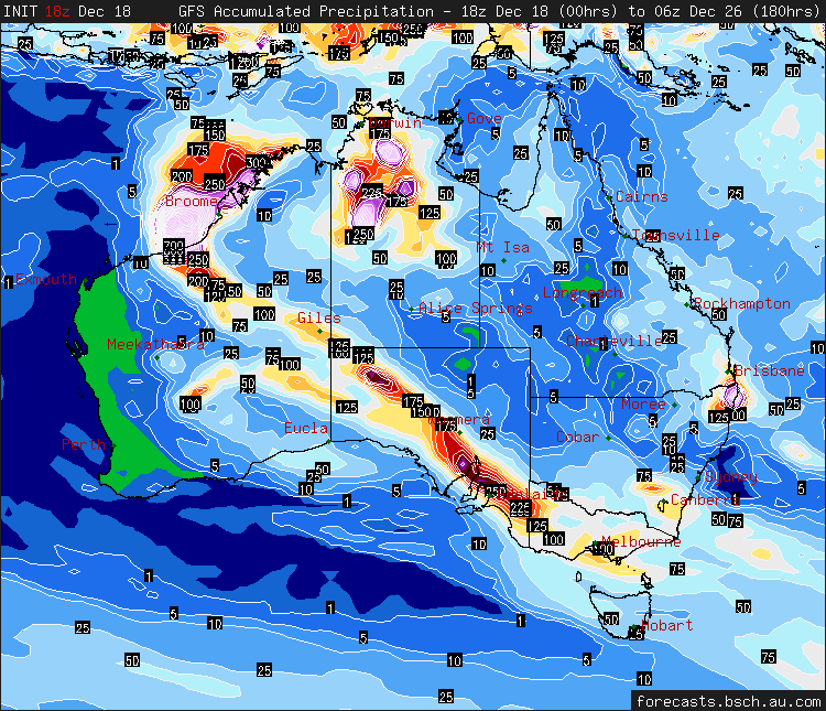
For reference point later...
Former Owner - The Australian Weather Forum. Email me anytime - weatherman1000@hotmail.com
-
Blackee
- Site Admin/Moderator
- Reactions:
- Posts: 3859
- Joined: Tue Nov 24, 2009 8:57 pm
- Location: Elwood and Mansfield 370m
Re: Looking towards substantial rainfall for SE Australia
A much more realistic 18z GFS this morning. Hopefully that is the bottom of their cycle, with any change going forward improves the rainfall totals.
Not overly excited about the chance of storms this week. Looks more likely after Christmas Day and before New Years.
Not overly excited about the chance of storms this week. Looks more likely after Christmas Day and before New Years.
Mansfield 370m and Elwood
-
Anthony Violi

- Supercell
- Reactions:
- Posts: 2652
- Joined: Mon Nov 23, 2009 9:03 pm
- Location: Lilydale
- Contact:
Re: Looking towards substantial rainfall for SE Australia
This system wont be it, but the next system between Boxing Day and the New year has massive potential if you look at extended EC...obviously a long way out but the signs are there for a lot of cold air and if that is the case we have moisture to burn over the continent. Only problem i see is that the Low would be developed too early, but if we see a LWT of that intensity it could be fireworks early new year.
http://www.therealworldweatherforum.com" onclick="window.open(this.href);return false;
avweatherforecasts.com
avweatherforecasts.com
-
Karl Lijnders
- Tornadic Supercell
- Reactions:
- Posts: 5771
- Joined: Sun Nov 22, 2009 11:17 pm
- Location: Knoxfield, Victoria
Re: Looking towards substantial rainfall for SE Australia
I sense a lot of bias from two corners within this communities, those for US and those for EC. And in times like these you get some totally opposite progs which makes things just so confusing and difficult. Looking over the coming week we are going to see this system beyond Thursday become the focal point.
I guess we can pen in 10-30mm over this week across the state. It is what happens beyond that we have to watch for.
No model will give a clear indication of what is going to happen, at this time there is so much divergence that no model run is more credible than another. On track record you can call EC over everything but even that is not a smart thing to do.
For us to get maximum rainfall here in the SE, the TC needs to cross further SW towards Pardoo to Karratha. I think that has a 20% chance of happening and could make things very interesting. The US run above is extreme but not without chance if this scenario were to pan out. We would also need a significant slow moving LWT and low pressure system to bomb in the region.
The latest US run is much more plausible with a stagnant sharp trough lifting moisture on the back of the Christmas weekend. This has a fair chance of happening with EC indicating over the last few days a bit of an easterly dip. We need to cradle a trough in the region and see all that moisture from TC Laurence lifted to cause scattered showers and thunderstorms for a few days. This could see rainfall of 50mm for many areas following the first fall this week.
Overall the outlook is super promising with tonnes of residual moisture. And then EC has a significant LWT developing over SW AUS towards the end of the run and with some luck could be here by NYE with some significant natural fireworks!!!
Former Owner - The Australian Weather Forum. Email me anytime - weatherman1000@hotmail.com