Just thought i'd open a chase thread for those interested in the event approaching in the next couple of days for areas of Victoria.
We could see a fairly solid outbreak of storms with a stalling trough on Tuesday and Wednesday, and then with a strong front to arrive Friday.
Your thoughts?

Welcome New Members! We want to hear from you. Register, stop lurking and start posting!
VIC Storms - 14th-17th October.

Re: VIC Storms - 14th-17th October.
Not overly excited by this one. Looks like southern and western areas will do best on Tuesday, before the focus shifts to the east on Wednesday. Happily be proven wrong tho. Definitely not planning a big chase day or anything tho, but if something makes its way here and I'm able to get out I'll go have a look.
Re: VIC Storms - 14th-17th October.
Latest GFS is disappointing for tomorrow unless your in the south west. Wednesday looks better for inland areas, although maybe a tad too far east for my liking. But, still looks like there will be some good storms around the state, so I'll sit back and see how it pans out.
-
Blackee

- Site Admin/Moderator
- Reactions:
- Posts: 3859
- Joined: Tue Nov 24, 2009 8:57 pm
- Location: Elwood and Mansfield 370m
Re: VIC Storms - 14th-17th October.
Wednesday is the pick of the days if some clear air avails inself.
Would be focusing around Northern Country VIC (Echuca) and east to Shepparton/Benalla.
Would be focusing around Northern Country VIC (Echuca) and east to Shepparton/Benalla.
Mansfield 370m and Elwood
- Hamlan
- Storm Chaser
- Reactions:
- Posts: 449
- Joined: Tue Dec 22, 2009 11:05 pm
- Location: Northern suburbs
Re: VIC Storms - 14th-17th October.
I've been watching this reasonably closely too as work will be taking me to C and NC Vic on Wed and Thurs mornings and chasing may be a chance for me in the afternoons.
Wed is certainly looking nice for the areas Sniper has suggested and at this stage I will be looking to go north from Kilmore to Nagambie or Euroa areas and reassess from there. CAPE is good and I notice shear is up too!
Thursday is a possibly a big play in southern NSW in the 'usual' areas north of Tocumwal to Wagga so keep an eye on that too.
-
Blackee
- Site Admin/Moderator
- Reactions:
- Posts: 3859
- Joined: Tue Nov 24, 2009 8:57 pm
- Location: Elwood and Mansfield 370m
Re: VIC Storms - 14th-17th October.
Based on the available data, I'd be heading to the following locations for some storm action:
Tuesday: South and south west of Ararat or south of Echuca (Elmore or Rochester)
Wednesday: Echuca
Thursday: Nathalia then to Echuca
Friday: Coastal Vic (cold air storms in association with the cold front/cold pool
Tuesday: South and south west of Ararat or south of Echuca (Elmore or Rochester)
Wednesday: Echuca
Thursday: Nathalia then to Echuca
Friday: Coastal Vic (cold air storms in association with the cold front/cold pool
Mansfield 370m and Elwood
- Jake Smethurst
- Supercell
- Reactions:
- Posts: 3583
- Joined: Mon Nov 23, 2009 8:49 pm
- Location: Cheltenham
Re: VIC Storms - 14th-17th October.
Heres my thoughts for tomorrow!!
Tuesday
The low pressure trough is set to advance into western Victoria during Tuesday but be relatively slow moving and even stall. Increases in moisture content, cold and unstable uppers, and warm surface temperatures, should see scattered showers and isolated thunderstorms develop, particularly during the afternoon over the western districts. GFS is highlighting the Western district with the strongest instability, LI values down to -3, but generally -1 to -2 values stretching across most western districts and even into the Northern Country; CAPE looking quite good as well up to 1000 over parts the Western district and values of up to 700-800 stretching across the Wimmera and western parts of the Northern Country forecast districts. The limiting factor of thunderstorm development on Tuesday will be increased cloud cover, so we will have to wait and see on that. Apart from that factor, they look good to develop across the districts mentioned above and there is the likleyhood for severe activity too, particularly in the way of flash flooding and damaging winds, but large hailstones are also possible. Movement of thunderstorms will be towards the southeast if they develop ...........
See my own storm charts in the link below on my signature!
Jake - Senior AWF Forecaster
Feel free to send me a private message if you have any questions.
Feel free to send me a private message if you have any questions.
-
Blackee
- Site Admin/Moderator
- Reactions:
- Posts: 3859
- Joined: Tue Nov 24, 2009 8:57 pm
- Location: Elwood and Mansfield 370m
Re: VIC Storms - 14th-17th October.
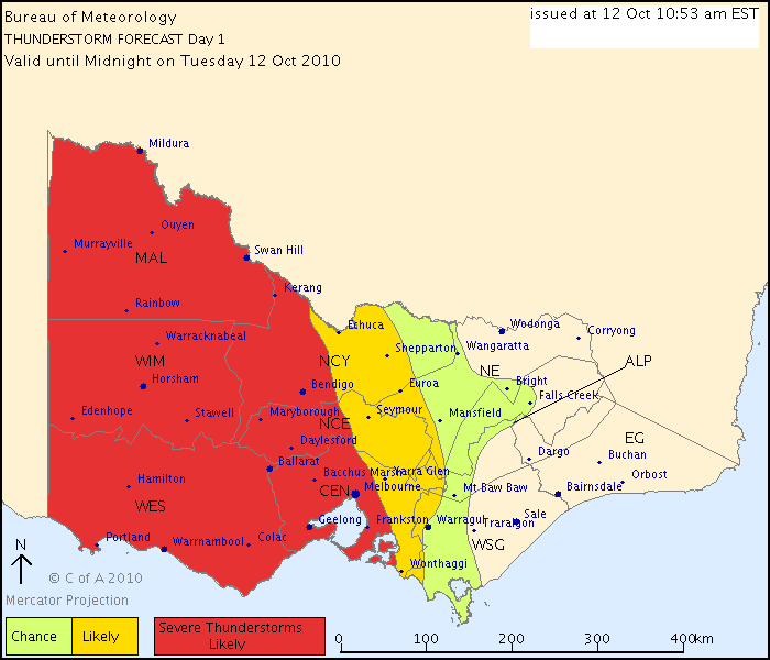
THUNDERSTORM FORECAST
Issued at 10:53 am Tuesday, 12 October 2010,
Valid until midnight on Tuesday, 12 October 2010.
A warm, humid and unstable airmass with a low pressure trough in the far
southwest moving to a position near Mildura to Melbourne at around midnight. Any
thunderstorm activity should be near the trough and flash flooding is likely
while large hail and strong winds are possible.
Mansfield 370m and Elwood
-
Blackee
- Site Admin/Moderator
- Reactions:
- Posts: 3859
- Joined: Tue Nov 24, 2009 8:57 pm
- Location: Elwood and Mansfield 370m
Re: VIC Storms - 14th-17th October.
A plot of 24/16 (current conditions at Geelong Ap) throws out the following:
CAPE: 1140 j/kg
LI: -3.97c
LCL: 898mb
CIN: 17 j/kg
CAPE: 1140 j/kg
LI: -3.97c
LCL: 898mb
CIN: 17 j/kg
Mansfield 370m and Elwood
-
Karl Lijnders

- Tornadic Supercell
- Reactions:
- Posts: 5771
- Joined: Sun Nov 22, 2009 11:17 pm
- Location: Knoxfield, Victoria
Re: VIC Storms - 14th-17th October.
John Allen and perhaps Brad are out in the Bendigo region on the NE side of the multicell coming towards Melbourne.
They have witnessed three seperate wall clouds, currently analyzing a very intense precip core adjacent and nearby a mesocyclone developing.
Not bad for a marginal day.
They have witnessed three seperate wall clouds, currently analyzing a very intense precip core adjacent and nearby a mesocyclone developing.
Not bad for a marginal day.
Former Owner - The Australian Weather Forum. Email me anytime - weatherman1000@hotmail.com
- Hamlan
- Storm Chaser
- Reactions:
- Posts: 449
- Joined: Tue Dec 22, 2009 11:05 pm
- Location: Northern suburbs
Re: VIC Storms - 14th-17th October.
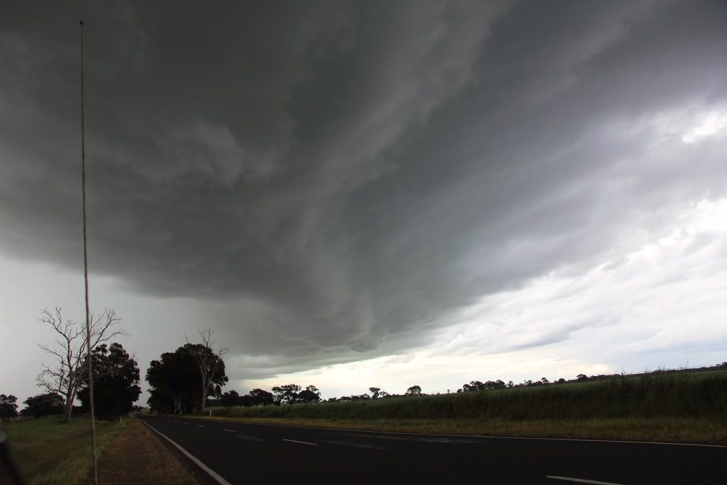
Hi all, yes Karl I was there too! We just experienced one of, if not the best Aussie chase we have been on - certainly a rewarding one. And the structure  mind blowing at times, in fact many times. There may well have been a tornado or tornadoes on this storm. Our pics will be very interesting. No confirmed touchdowns at this stage. Regardless, a phenomenal long-lived supercell.
Wow, and on what was initially a marginal day! We just spent over 4 hours on the one cycling supercell with so many SERIOUS wall clouds and structure to die for and we got up close and personal!
We got onto this cell mid arvo near Maldon after ditching 2 otherwise impressive wall clouds (both complete with inflow tails and rapid scud rotation and upmotion) to it's south then had an amazing chase through some tough country and we were still chasing it as it cycled another wall cloud at Broadford on the Hume! We had to core punch several times to flank and outflank it due to roads and geography and got decent hail to 5cm (including a few dents oops) while in the RFD on one occasion. Was amazing to watch this thing cycle and produce wall cloud after wall cloud after wall cloud - it was a machine.
- rikjpool
- Storm Chaser
- Reactions:
- Posts: 989
- Joined: Thu Nov 26, 2009 1:46 pm
- Location: Home: North Bendigo-just behind Lake Weeroona, Vic. Work: 1.5Km SE from Bendigo AWS
Re: VIC Storms - 14th-17th October.
Cant wait to see the pics guys. 
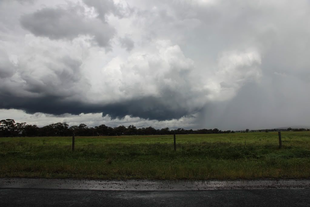
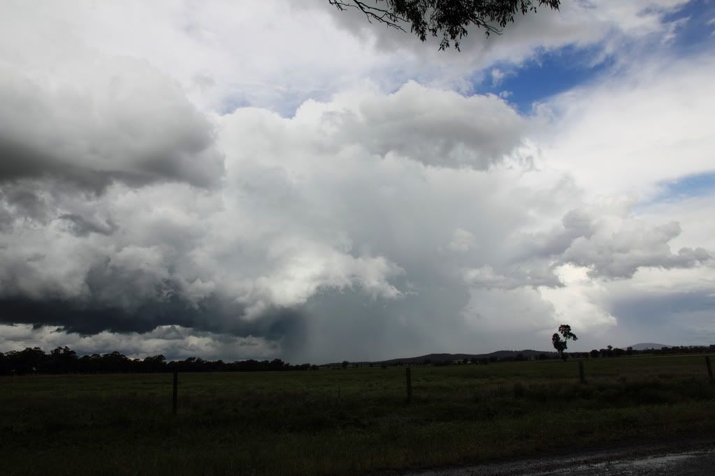
Heres a quick little report from a 10min chase I managed to squeeze in after work before mums birthday, would be good to see if i managed to snag a wallcloud off of the same storm. Was on One Tree Hill looking due S-SSE\
A couple of pictures I did manage to get yesterday after work. Cant wait to see John and Brads. Keep an eye out for the in the Storm Chasing Thread.
This first one is actually the tail end of the massive line from a couple of nights ago, taken from One Tree Hill as it went through Dayleford.
The anvil was being lit up in the perfect line's pointing straight towards the storm cell.

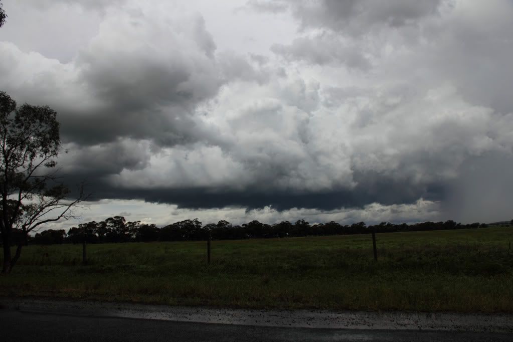
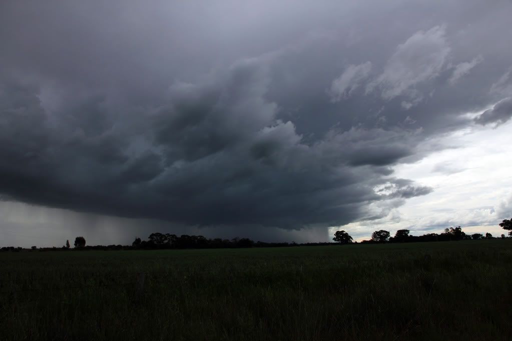
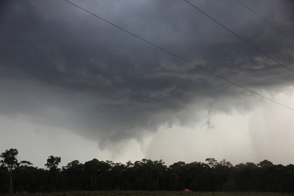
Now for yesterday. This first picture was, i think, the storm that Brad and John were on, but taken from a good 35km away at 200mm. The Scud was litterally being scraped off of the ground, leading me to believe there was a funnel there for a bit, but after a good 1min looking through the glass, no rotation was noted in this pick. Time signature around 529pm

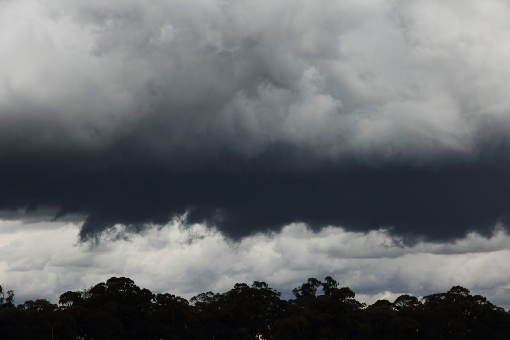
And this is i'm fairly sure one of the many wall clouds that this storm produced. It stayed like this for a good 7-9min, leading me to think it wasnt just scud, but something more. Time Sugnature on this one to compare for John and Brad would be around the 538pm mark

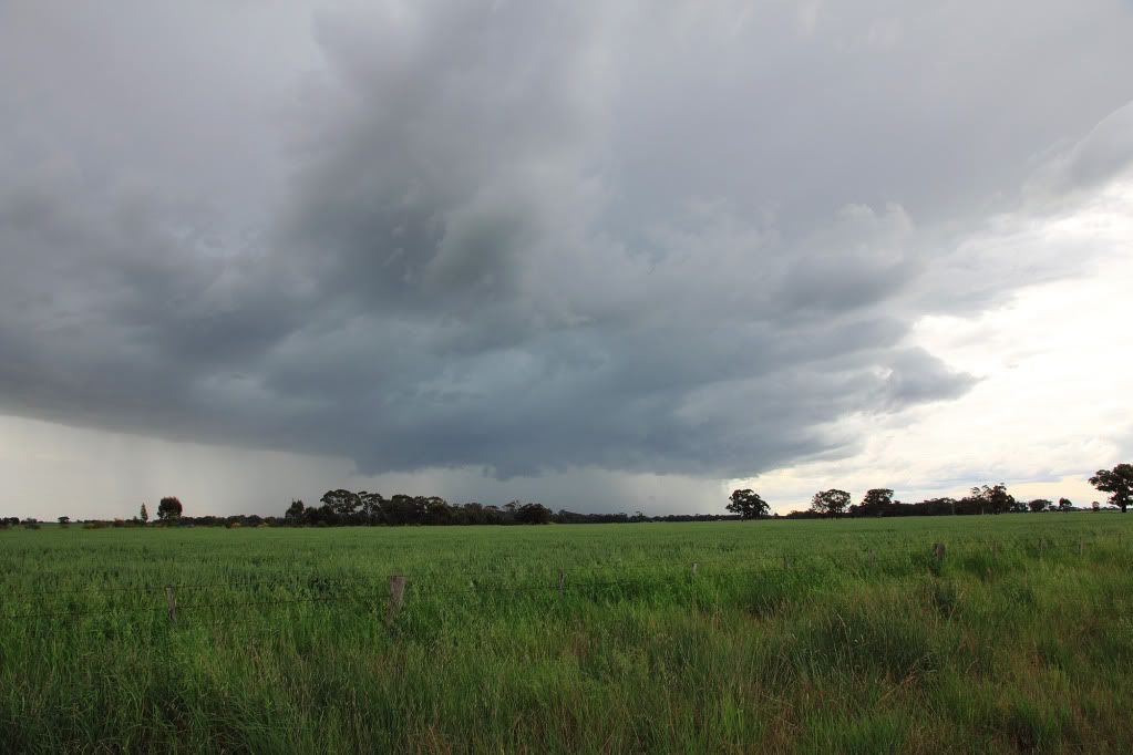
This was what I could make out through the haze and over the other side of Big Hill (kangaroo Flat) that would have been the initiall line with nice gust front that collided with the cell that J&B were onto. Contrasted heavily to make it out.

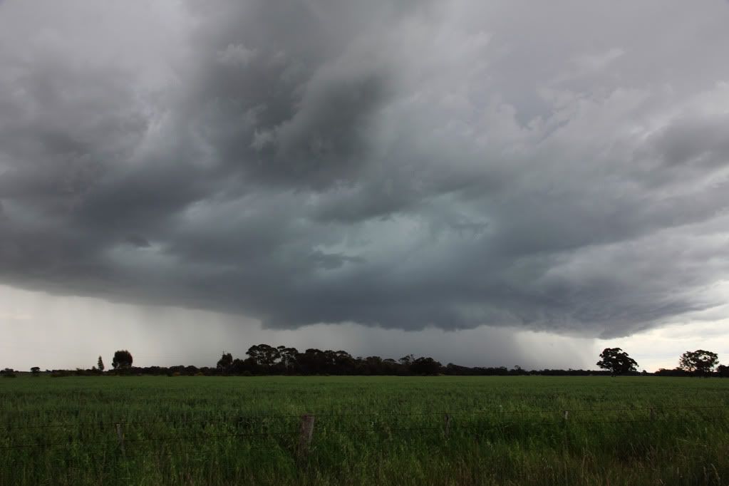
And finally a picture of the red cell as it was starting to Bow out over NorthWest Bendigo, that turned into a Left mover NW of Bendigo. Quite sure this is the same storm at a later stage that Meso has pics of. Sorry about the quality, stupid me forgot to put the focus back on auto on the lens, and on the LCD it looked in focus, But you get the idea.

Heres a quick little report from a 10min chase I managed to squeeze in after work before mums birthday, would be good to see if i managed to snag a wallcloud off of the same storm. Was on One Tree Hill looking due S-SSE\
A couple of pictures I did manage to get yesterday after work. Cant wait to see John and Brads. Keep an eye out for the in the Storm Chasing Thread.
This first one is actually the tail end of the massive line from a couple of nights ago, taken from One Tree Hill as it went through Dayleford.
The anvil was being lit up in the perfect line's pointing straight towards the storm cell.
Now for yesterday. This first picture was, i think, the storm that Brad and John were on, but taken from a good 35km away at 200mm. The Scud was litterally being scraped off of the ground, leading me to believe there was a funnel there for a bit, but after a good 1min looking through the glass, no rotation was noted in this pick. Time signature around 529pm
And this is i'm fairly sure one of the many wall clouds that this storm produced. It stayed like this for a good 7-9min, leading me to think it wasnt just scud, but something more. Time Sugnature on this one to compare for John and Brad would be around the 538pm mark
This was what I could make out through the haze and over the other side of Big Hill (kangaroo Flat) that would have been the initiall line with nice gust front that collided with the cell that J&B were onto. Contrasted heavily to make it out.
And finally a picture of the red cell as it was starting to Bow out over NorthWest Bendigo, that turned into a Left mover NW of Bendigo. Quite sure this is the same storm at a later stage that Meso has pics of. Sorry about the quality, stupid me forgot to put the focus back on auto on the lens, and on the LCD it looked in focus, But you get the idea.
I live in a world where I dont see to believe, but I believe to see...
-
AUSSKY

- Storm Chaser
- Reactions:
- Posts: 538
- Joined: Wed Nov 25, 2009 11:59 pm
- Location: Trentham (700m ASL)
- Contact:
Re: VIC Storms - 14th-17th October.
Hi all.....Got a report from Julian Hollis at Castlemaine of a long lived funnel moving east/southeast north of the town between 1715 and 1745 Tuesday 12/10/10, frequent lightning and rotating wall cloud, there was a good Doppler signiture between 1730 and 1830hrs before the storm was over-run by a squall line....Clyve H
Australian Sky & Weather (AUSSKY)
Victoria - The State of Drizzle & Occasional Tornadoes
(1999 -2016)
Victoria - The State of Drizzle & Occasional Tornadoes
(1999 -2016)
Re: VIC Storms - 14th-17th October.
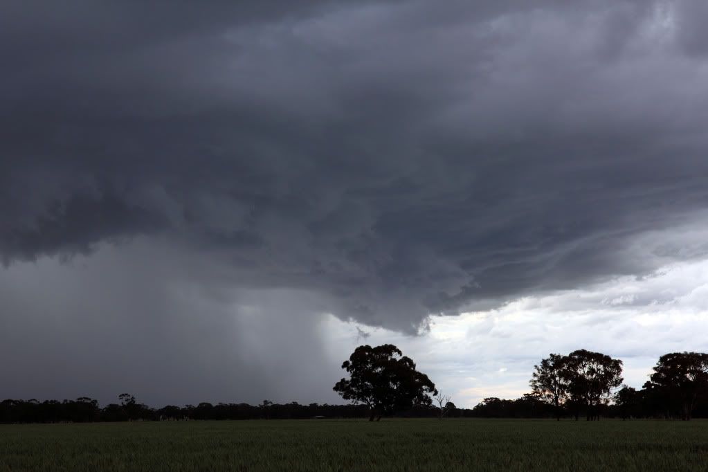
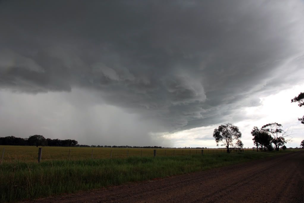
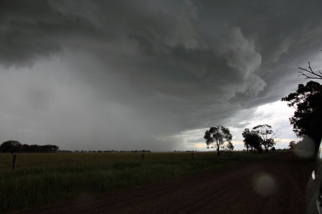
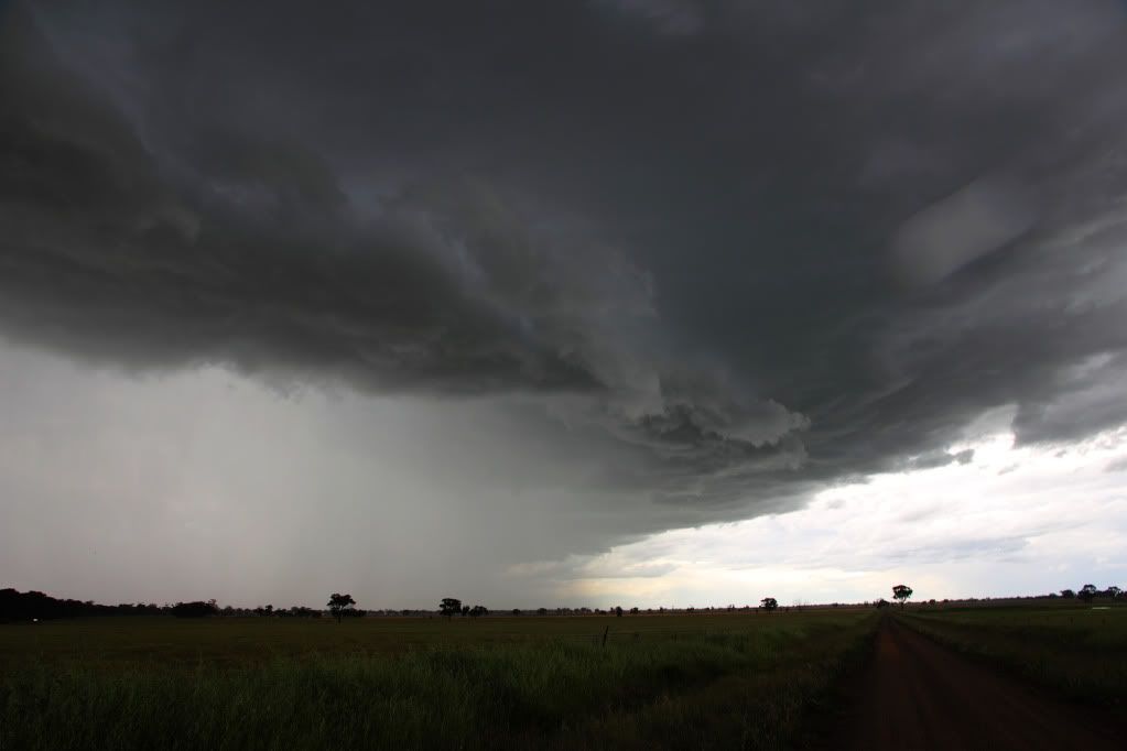
Hi All
Michael King from Canberra here. Chased yesterday Shelbourne to Redesdale (3.00 to 5.30 pm) behind and beside beautiful cell, which was almost text book, updraft at back of the storm, at least to Mt Alexander. Storm was very slow moving, especially in early stages. I am a mostly a 'Dolly Parton' (9 to 5) chaser so signed off at Redesdale and in any case that storm was about to be overtaken by trough line.
Here are some photos.


-
Blackee
- Site Admin/Moderator
- Reactions:
- Posts: 3859
- Joined: Tue Nov 24, 2009 8:57 pm
- Location: Elwood and Mansfield 370m
Re: VIC Storms - 14th-17th October.
Michael,
Firstly welcome aboard and thankyou for your contribution.
You were certainly rewarded for your efforts yesterday!!
We look forward to your next chapter....
Firstly welcome aboard and thankyou for your contribution.
You were certainly rewarded for your efforts yesterday!!
We look forward to your next chapter....
Mansfield 370m and Elwood
-
AUSSKY
- Storm Chaser
- Reactions:
- Posts: 538
- Joined: Wed Nov 25, 2009 11:59 pm
- Location: Trentham (700m ASL)
- Contact:
Re: VIC Storms - 14th-17th October.
Michael,
thanks for sharing your photos!!! It's great to be able to stormchase from my desk - goes some way to mitigating the frustration of not being able to be out there amongst it.
Look forward to seeing John's photos of the storm on the other side of Mt Alexander to complete the storm's journey....
Jane
thanks for sharing your photos!!! It's great to be able to stormchase from my desk - goes some way to mitigating the frustration of not being able to be out there amongst it.
Look forward to seeing John's photos of the storm on the other side of Mt Alexander to complete the storm's journey....
Jane
Australian Sky & Weather (AUSSKY)
Victoria - The State of Drizzle & Occasional Tornadoes
(1999 -2016)
Victoria - The State of Drizzle & Occasional Tornadoes
(1999 -2016)
Re: VIC Storms - 14th-17th October.
Thanks for kind words Sniper, John and Jane. John, I was in blue Mazda 6 - glad you had a top chase. The Mt Alexander photo doesn't do the structure justice, unfortunately and the rear end vista heading from Maldon to the Calder was also notable. I did go past Mt Alexander but couldn't get a sealed north south road while I drove east towards Redesdale. Must admit I was getting a bit blase (sp?) at that point. I did venture south down the Metcalfe road (last photo) but was worried about getting stuck on an unsealed road in adverse conditions. The ground hugging scud yesterday was something I haven't seen too often. Thank you Victoria!
Re: VIC Storms - 14th-17th October.
Great photos Micheal and welcome to the forum! There certainly was some great cells around yesterday for those who ventured out. I think I remember Karl saying they wouldn't be too photogenic early on in the day, well I think you were proven wrong Karl! 
Here's what I managed to see.
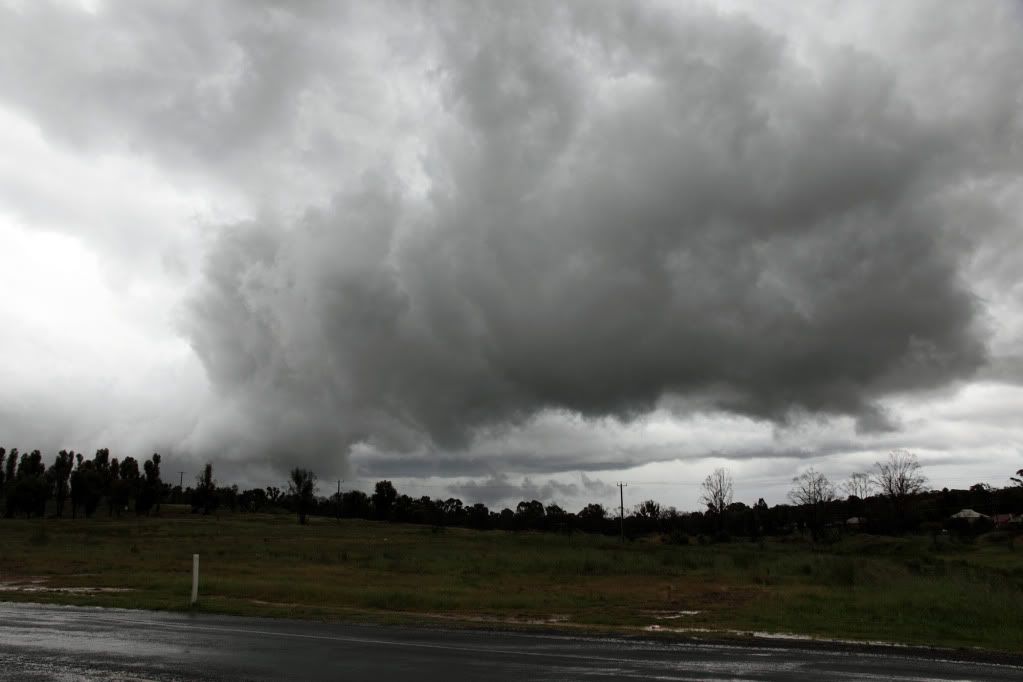
First cell I caught was near Maryborough, had a massive rain/hail curtain on it and I didn't follow the cell too long. You can see a tinge of green in the first photo so I suspect their may have been some hail in there somewhere. As you can see from the photos it was really dumping!
After taking a few photos of the Maryborough cell, I quickly checked the radar and decided to head towards a cell coming down past Birchip. After driving for 10 mins or so I realised the GPS was taking me through St Arnaud way, which is a terrible area for chasing with all the trees. So, I thought better of it and turned around and headed back towards Bendigo, basically with the attitude of "Whatever happens, happens, if I see something, great, otherwise, oh well..." I think I should take this attitude more often as I spotted a nice cell as I was coming through Bridgewater heading SE to Bendigo.
Managed to stay in front of it from Bridgewater to Marong, whilst periodically stopping to take a few shots...
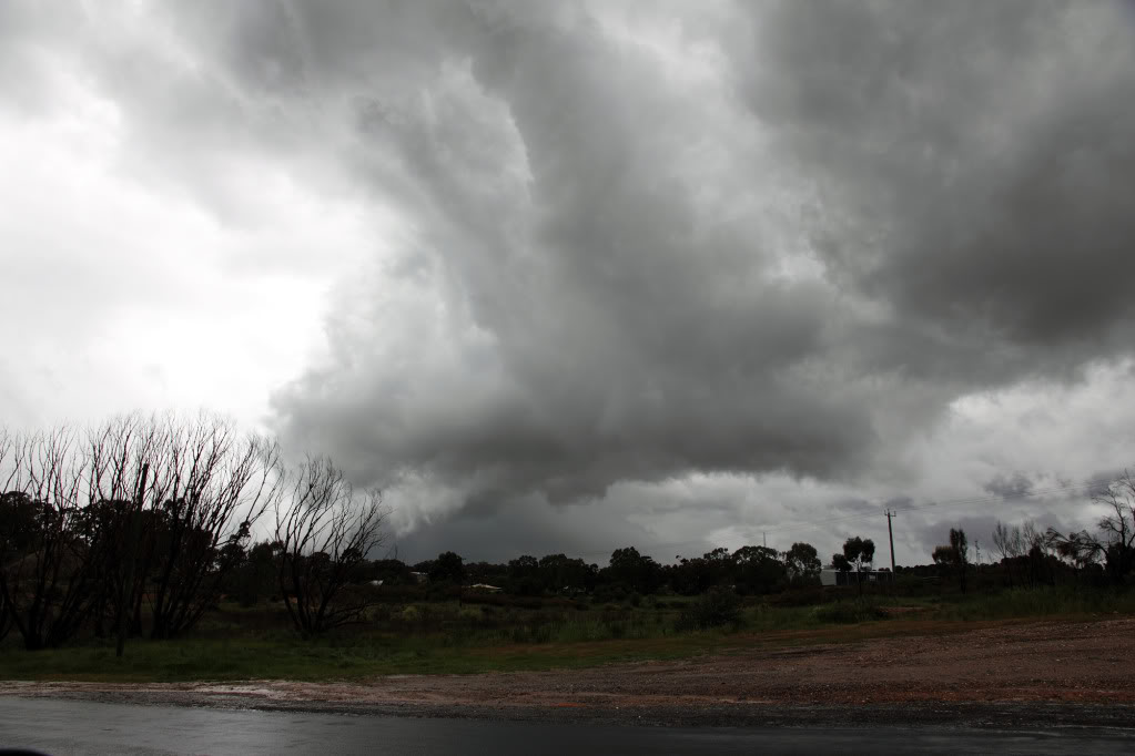
Somewhere near Marong after darting around trying to get a better view I was smashed by the core and basically had to drive 40-50km/h back to Eaglehawk due to whiteout conditions and strong winds sending branches all over the road.
Emerged from the core between Eaglehawk and Golden Square in Bendigo and managed to get another view on it before following it to my front door step...
Some nice low scud getting sucked in to the storm in this first shot...
Gave up on it after that and went and had some dinner. All in all a most enjoyable chase, with no long trip home afterwards, which was a bonus
Here's what I managed to see.
First cell I caught was near Maryborough, had a massive rain/hail curtain on it and I didn't follow the cell too long. You can see a tinge of green in the first photo so I suspect their may have been some hail in there somewhere. As you can see from the photos it was really dumping!
After taking a few photos of the Maryborough cell, I quickly checked the radar and decided to head towards a cell coming down past Birchip. After driving for 10 mins or so I realised the GPS was taking me through St Arnaud way, which is a terrible area for chasing with all the trees. So, I thought better of it and turned around and headed back towards Bendigo, basically with the attitude of "Whatever happens, happens, if I see something, great, otherwise, oh well..." I think I should take this attitude more often as I spotted a nice cell as I was coming through Bridgewater heading SE to Bendigo.
Managed to stay in front of it from Bridgewater to Marong, whilst periodically stopping to take a few shots...
Somewhere near Marong after darting around trying to get a better view I was smashed by the core and basically had to drive 40-50km/h back to Eaglehawk due to whiteout conditions and strong winds sending branches all over the road.
Emerged from the core between Eaglehawk and Golden Square in Bendigo and managed to get another view on it before following it to my front door step...
Some nice low scud getting sucked in to the storm in this first shot...
Gave up on it after that and went and had some dinner. All in all a most enjoyable chase, with no long trip home afterwards, which was a bonus
- Hamlan
- Storm Chaser
- Reactions:
- Posts: 449
- Joined: Tue Dec 22, 2009 11:05 pm
- Location: Northern suburbs
Re: VIC Storms - 14th-17th October.
Awesome! someone else got out on the storm too! what a show it was, I still cant get over it. We certainly were close to you Michael and also went through Redesdale (to get fuel!). Hope to have some pics up tonight. For structure and contrast, I think they could be amongst my best Aussie storm shots yet having looked at them late last night and include some very close calls with respect to tornado calls but not confident of confirming any yet.
Brad
Oh, and mods I think we need a change to the thread title to include the 12th Oct! thanks
Brad
Oh, and mods I think we need a change to the thread title to include the 12th Oct! thanks
-
AUSSKY
- Storm Chaser
- Reactions:
- Posts: 538
- Joined: Wed Nov 25, 2009 11:59 pm
- Location: Trentham (700m ASL)
- Contact:
Re: VIC Storms - 14th-17th October.
Meso,
great shots!!!!! What a fabulous day you guys have had.
Thanks for sharing your images.
Jane
great shots!!!!! What a fabulous day you guys have had.
Thanks for sharing your images.
Jane
Australian Sky & Weather (AUSSKY)
Victoria - The State of Drizzle & Occasional Tornadoes
(1999 -2016)
Victoria - The State of Drizzle & Occasional Tornadoes
(1999 -2016)