
Dunno if John is doing a forecast thread this week, so thought I would get something going and hopefully get some input on the storm chances for Thursday as it begins to draw closer (feel free to rename the thread).
Anyway, Stormcast is looking better and better with each run. Instability seems to peak up SW of Hay along the border and in to Victoria between probably Echuca and Bendigo and eastern parts of the Mallee. CAPE up to 900 j/kg and LI's down to -4 gives me reason to believe severe storms are on the cards. Heating looks ok north of the border and around the Mallee too, with temps in the low 20's. Shear doesn't look too impressive to me, but hopefully John or someone else can elaborate on that.
On current forecasts I will definitely be out chasing, as the bulk of the action looks to be nice and close to home.

Welcome New Members! We want to hear from you. Register, stop lurking and start posting!
Possible storms - 9/9/2010
Re: Possible storms - 9/9/2010
Good reading as usual, John. Funny you should be worried about it retreating north or west as that is exactly what the 06z has done with it. I think I will just keep quiet and try not look at it again til Wednesday in case I jinx it. 
- Hamlan
- Storm Chaser
- Reactions:
- Posts: 449
- Joined: Tue Dec 22, 2009 11:05 pm
- Location: Northern suburbs
Re: Possible storms - 9/9/2010
I am watching this possible event on Thursday closely as I will be in Barham NSW (just over the border from Kerang and west of Denilliquin) for work in the morning! I will be chasing after I have completed my work 
In the absence of Meso (cos he's not watching till Wednesday hehe ), I was looking at the recent 12z run for 2pm and 5pm Thursday (and considering yesterdays runs) and now the new 18z run has come out and there's a nice consistent pattern in the runs of -3 and -4 LI's and CAPE around 7-800 in the area of Kerang with low bases below 900mb on the cards again by the looks of the soundings!
In the absence of Meso (cos he's not watching till Wednesday hehe
Re: Possible storms - 9/9/2010
Well, I've been keeping on eye on the stormcast (couldn't help myself), but I really don't know what to make of it. Instability is going up and down with each run, moving east, then west, then back again. The latest run is really hard to get a gauge on, looks like a slight downgrade for the late afternoon, yet a minor upgrade for the 2pm output.
Anyway, I'm at a bit of a lost for where to target tomorrow, somewhere NW looks good for early afternoon, after that I have no idea what is going to happen.
Anyway, I'm at a bit of a lost for where to target tomorrow, somewhere NW looks good for early afternoon, after that I have no idea what is going to happen.
- Harley34
- Cumulonumbus Calvas
- Reactions:
- Posts: 580
- Joined: Sat Mar 06, 2010 1:08 pm
- Location: Ringwood East, Melbourne
Re: Possible storms - 9/9/2010
Would just like to know, can anyone please explain the difference between high-based thunderstorms and low-based thunderstorms, and what causes the difference?
- Lily
- Supercell
- Reactions:
- Posts: 4014
- Joined: Wed Nov 25, 2009 10:29 pm
- Location: Rowville/Lysterfield
Re: Possible storms - 9/9/2010
Here's the link to the Vicroads Flood Traffic updates: http://mobiletraffic.vicroads.vic.gov.au/floodalerts" onclick="window.open(this.href);return false;
Have fun
Have fun
- Hamlan
- Storm Chaser
- Reactions:
- Posts: 449
- Joined: Tue Dec 22, 2009 11:05 pm
- Location: Northern suburbs
Re: Possible storms - 9/9/2010
Storms have broken out along the coastal fringe and are discrete splitting supercells. A large HP cell is moving along the coastline, while numerous left and right moving SCs exist on a line from Warnambool to Horsham. These storms have the significant potential to produce strong winds and large hail, and are displaying divergent motion. Whether they continue to persist as discrete storms remains in question, as the shear environment is not absolutely optimal in the south region for continual SC development. Brad and I are heading for St Arnaud atm to intercept the trough as it comes through, and storms will likely fire along this line as the insolation peaks with the SW passage. We can currently seeing strong convection in the distance to the west but are somewhat limited by the closure of some west rds. Goodluck if you get out.
- Hamlan
- Storm Chaser
- Reactions:
- Posts: 449
- Joined: Tue Dec 22, 2009 11:05 pm
- Location: Northern suburbs
Re: Possible storms - 9/9/2010
Strong cell near St Arnaud, looks to have base features and is organised. We are approaching it and it looks very impressive.
Re: Possible storms - 9/9/2010
Nice guys great coverage, keep us updated!
- Lily
- Supercell
- Reactions:
- Posts: 4014
- Joined: Wed Nov 25, 2009 10:29 pm
- Location: Rowville/Lysterfield
Re: Possible storms - 9/9/2010
Hey Fu  Glad to here you got onto it, guys, was wondering where you were when we saw it go black!
-
stratospear

- Supercell
- Reactions:
- Posts: 1261
- Joined: Sat Dec 19, 2009 9:38 am
- Location: Usually Bendigo
Re: Possible storms - 9/9/2010
Thunder and now quite heavy rain here.
-
Karl Lijnders

- Tornadic Supercell
- Reactions:
- Posts: 5771
- Joined: Sun Nov 22, 2009 11:17 pm
- Location: Knoxfield, Victoria
Re: Possible storms - 9/9/2010
Yeah these clumps could be pulsey and dump some heavy rain and intense lightning at times the quickly die off. Still the activity is building weekly and we seem to be getting weekly events ahead of the warmer weather.
Looking very encouraging.
Looking very encouraging.
Former Owner - The Australian Weather Forum. Email me anytime - weatherman1000@hotmail.com
Re: Possible storms - 9/9/2010
I was on this cell too, thought I saw a wall cloud as well, but can't be sure. Man, the area sucks to chase in, way too many trees and hardly anywhere to get a good view! Still, a nice looking storm once I could find a spot to take it in, lightning was quite infrequent which was a shame.Towering Updraft wrote:Apologies for not continuing on the coverage folks. Got a little busy there with Video and camera plus navigating....we got a well structured supercell...bit of a tail end charlie, we punched the storm 3 times and got in really close...excellent rotation and a well organised wall cloud...we only wish we had been on it sooner given what we saw from a distance. Still some large hail, impressive RFD...and even a bit of mammatus for variety. The trees in the area made it hard, and radar really didnt do what we were seeing justice. Very happy with the results though. Brad might find time to post some photos while I am on a weekend away with the missus.
- Hamlan
- Storm Chaser
- Reactions:
- Posts: 449
- Joined: Tue Dec 22, 2009 11:05 pm
- Location: Northern suburbs
Re: Possible storms - 9/9/2010
Couldnt help myself, had to post
Sitting near Maldon watching the cells dying with some sporadic lightning complete with stars!
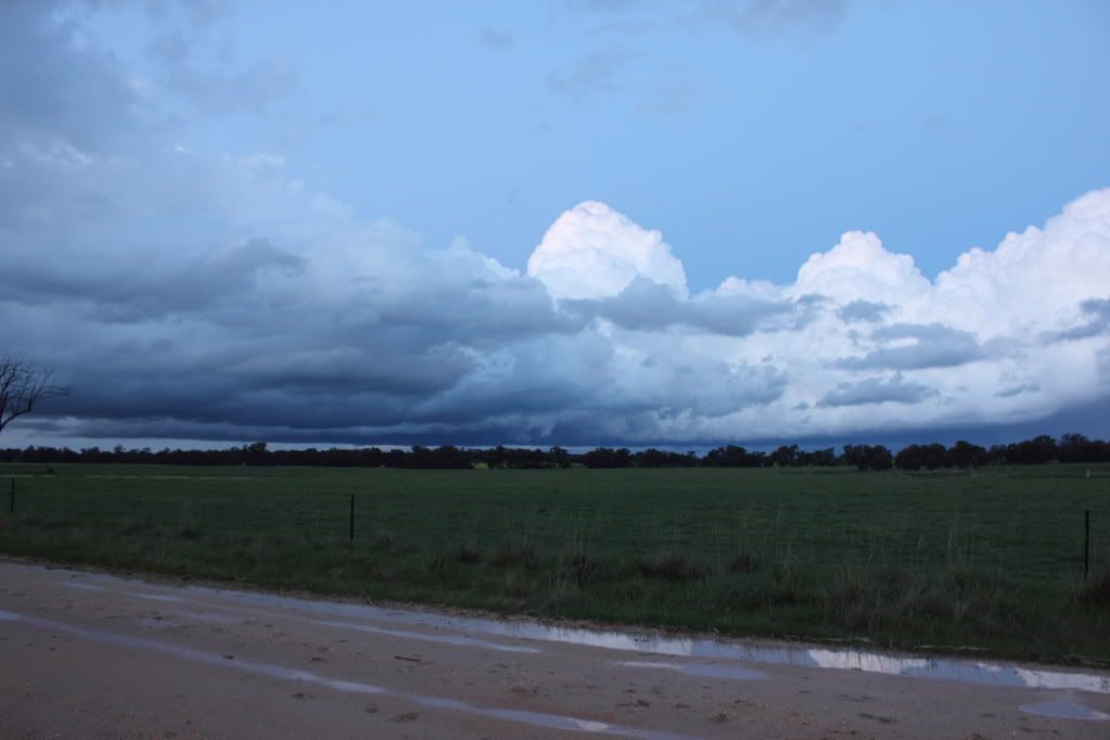
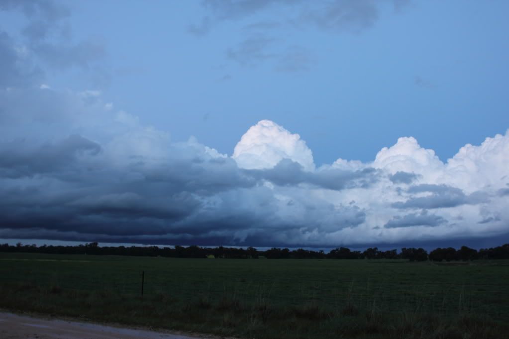
What a chase this was. Is without a doubt one of the most satisfying and best Aussie chase outcomes i've experienced and all on a day where the models had flip flopped so much and our expectations at 4pm were not too high, although we expected storms in the region and the tell tale signs were good with instability evident and good surface heating. Pity radar did not and will not do this storm justice. Lucky the pics and video will!
When we saw the structure of this cell including an extremely low and strong wall cloud a fair way to our west it was hard not to go beserk! Then after a concentrated effort to get close, we did! To say we were a bee's proverbial from a tornado today with the low base and strong persistent rotation is not exaggerating, and we were under the wall cloud north west of St Arnaud!
I will focus on getting home now, meanwhile John is having a roast dinner at his inlaws, sheesh.
Brad
Sitting near Maldon watching the cells dying with some sporadic lightning complete with stars!
What a chase this was. Is without a doubt one of the most satisfying and best Aussie chase outcomes i've experienced and all on a day where the models had flip flopped so much and our expectations at 4pm were not too high, although we expected storms in the region and the tell tale signs were good with instability evident and good surface heating. Pity radar did not and will not do this storm justice. Lucky the pics and video will!
When we saw the structure of this cell including an extremely low and strong wall cloud a fair way to our west it was hard not to go beserk! Then after a concentrated effort to get close, we did! To say we were a bee's proverbial from a tornado today with the low base and strong persistent rotation is not exaggerating, and we were under the wall cloud north west of St Arnaud!
I will focus on getting home now, meanwhile John is having a roast dinner at his inlaws, sheesh.
Brad
- rikjpool
- Storm Chaser
- Reactions:
- Posts: 989
- Joined: Thu Nov 26, 2009 1:46 pm
- Location: Home: North Bendigo-just behind Lake Weeroona, Vic. Work: 1.5Km SE from Bendigo AWS
Re: Possible storms - 9/9/2010
Can you check the Dopplar signatures at yarrawonga from tonight between 7:30pm and 8:30pm... Strong Meso on the cell south of Deni? and possible one near Numurkah as well?
I live in a world where I dont see to believe, but I believe to see...
Re: Possible storms - 9/9/2010
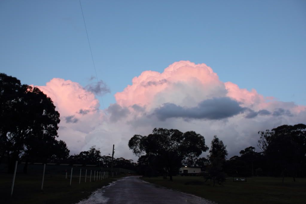
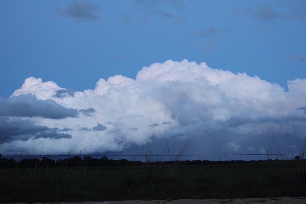
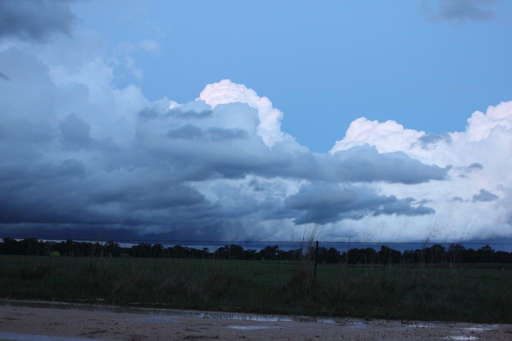
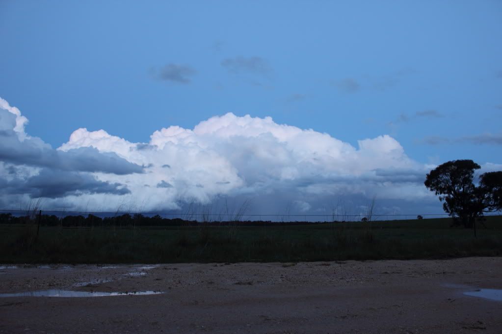
Few pics from the St Arnaud storm, the towers on this thing were beautiful!
View from the golf club...
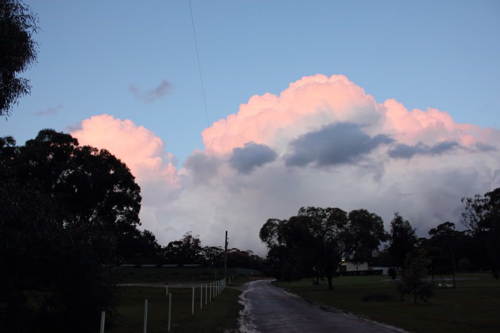
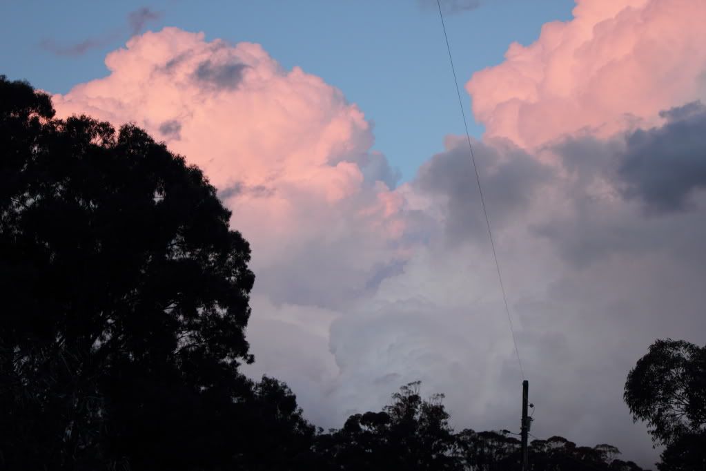
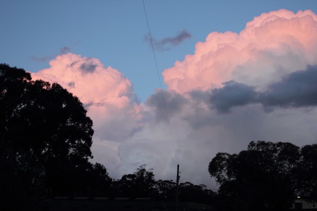
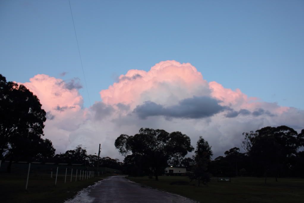
And from a paddock, just outside the town...
View from the golf club...
And from a paddock, just outside the town...
-
Rivergirl

- Memorial
- Reactions:
- Posts: 3674
- Joined: Sun Nov 22, 2009 6:04 pm
- Location: Ferny Creek VIC
- Contact:
Re: Possible storms - 9/9/2010
Fantastic photos!
- Hamlan
- Storm Chaser
- Reactions:
- Posts: 449
- Joined: Tue Dec 22, 2009 11:05 pm
- Location: Northern suburbs
Re: Possible storms - 9/9/2010
I just had a look at radar here: http://radar.strikeone.net.au/ and there are two things I note:rikjpool wrote:Can you check the Dopplar signatures at yarrawonga from tonight between 7:30pm and 8:30pm... Strong Meso on the cell south of Deni? and possible one near Numurkah as well?
1. The beast of a storm John and I were on (and under!) barely even reflects on any Vic radars so the old radar black hole exists in all its glory but we did know that this arvo - when you see the pics you'll see it's an idictment on the BOM to have such a lack of coverage in an area that gets its fair share of severe weather and this arvo was no exception.
2. The NSW storm Rikki mentioned appears to split dramatically with a slight left mover and a serious right mover that explodes south of Deniliquin and then again over the Vic border near Numurkah - Wow!
Nice shots Meso - you werent far from us. We saw some of that nice sunset too. I think at the time of your shots we were racing east to try and core punch for a 3rd time. Not the tallest storm but gee wiz, the structure and the fact it nearly produced a strong long lived wall cloud and almost tornado goes to show yet again in Vic you dont always need the highest storm parameter values (LI's and CAPE) to come together to get severe action.
Re: Possible storms - 9/9/2010
Couple of clips from the St Arnaud storm yesterday...
" onclick="window.open(this.href);return false;
" onclick="window.open(this.href);return false;
They're in HD too if you can be bothered clicking the thing on the bottom right of the video player.
" onclick="window.open(this.href);return false;
" onclick="window.open(this.href);return false;
They're in HD too if you can be bothered clicking the thing on the bottom right of the video player.